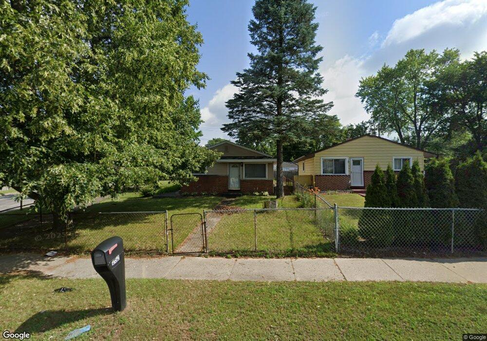
232 W Kennett Rd Pontiac, MI 48340
Estimated Value: $126,000 - $172,000
3
Beds
1
Bath
870
Sq Ft
$170/Sq Ft
Est. Value
About This Home
This home is located at 232 W Kennett Rd, Pontiac, MI 48340 and is currently estimated at $148,179, approximately $170 per square foot. 232 W Kennett Rd is a home located in Oakland County with nearby schools including Alcott School, Pontiac Middle School, and Pontiac High School.
Ownership History
Date
Name
Owned For
Owner Type
Purchase Details
Closed on
Oct 27, 2000
Sold by
Wyrick Scott E
Bought by
Anderson R
Current Estimated Value
Purchase Details
Closed on
Aug 24, 1998
Sold by
Bankston Brett A
Bought by
Wyrick Scott
Purchase Details
Closed on
May 22, 1997
Sold by
Norwest Mortgage Inc
Bought by
Veterans Affairs Admin Of
Purchase Details
Closed on
Dec 21, 1994
Sold by
Juanita J Garcia Est
Bought by
Klein James A
Home Financials for this Owner
Home Financials are based on the most recent Mortgage that was taken out on this home.
Original Mortgage
$46,400
Interest Rate
9.24%
Create a Home Valuation Report for This Property
The Home Valuation Report is an in-depth analysis detailing your home's value as well as a comparison with similar homes in the area
Home Values in the Area
Average Home Value in this Area
Purchase History
| Date | Buyer | Sale Price | Title Company |
|---|---|---|---|
| Anderson R | $105,000 | -- | |
| Wyrick Scott | $89,000 | -- | |
| Veterans Affairs Admin Of | -- | -- | |
| Klein James A | $45,500 | -- |
Source: Public Records
Mortgage History
| Date | Status | Borrower | Loan Amount |
|---|---|---|---|
| Previous Owner | Klein James A | $46,400 | |
| Closed | Anderson R | -- |
Source: Public Records
Tax History Compared to Growth
Tax History
| Year | Tax Paid | Tax Assessment Tax Assessment Total Assessment is a certain percentage of the fair market value that is determined by local assessors to be the total taxable value of land and additions on the property. | Land | Improvement |
|---|---|---|---|---|
| 2024 | $825 | $48,320 | $0 | $0 |
| 2023 | $787 | $43,170 | $0 | $0 |
| 2022 | $827 | $38,660 | $0 | $0 |
| 2021 | $803 | $33,520 | $0 | $0 |
| 2020 | $715 | $29,540 | $0 | $0 |
| 2019 | $777 | $25,660 | $0 | $0 |
| 2018 | $744 | $24,050 | $0 | $0 |
| 2017 | $707 | $23,010 | $0 | $0 |
| 2016 | $733 | $20,230 | $0 | $0 |
| 2015 | -- | $19,720 | $0 | $0 |
| 2014 | -- | $18,830 | $0 | $0 |
| 2011 | -- | $23,260 | $0 | $0 |
Source: Public Records
Map
Nearby Homes
- 998 Dewey St
- 255 W Rutgers Ave
- 119 W Kennett Rd
- 201 Parkdale Ave
- 1017 Cherrylawn Dr
- 240 W Fairmount Ave
- 137 Dresden Ave
- 109 W Kennett Rd
- 207 W Strathmore Ave
- 134 W Fairmount Ave
- 117 W Strathmore Ave
- 1153 Stanley Ave
- 1123 Cherrylawn Dr
- 33 W Beverly Ave
- 112 W Strathmore Ave
- 32 N Merrimac St
- 18 E 18 E Rutgers Ave
- 709 Kinney Rd
- 841 Orlando Ave
- 0000 Blaine Ave
- 228 W Kennett Rd
- 984 Fairview Ave
- 244 W Kennett Rd
- 988 Fairview Ave
- 979 Dewey St
- 216 W Kennett Rd
- 983 Dewey St
- 992 Fairview Ave
- 987 Dewey St
- 227 W Kennett Rd
- 248 W Kennett Rd
- 989 Fairview Ave
- 991 Dewey St
- 996 Fairview Ave
- 243 W Kennett Rd
- 252 W Kennett Rd
- 995 Dewey St
- 1000 Fairview Ave
- 993 Fairview Ave
- 999 Dewey St