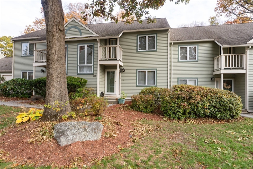
232 Weatherstone Dr Worcester, MA 01604
Broadmeadow Brook NeighborhoodEstimated payment $2,652/month
Highlights
- Medical Services
- Property is near public transit
- Soaking Tub
- In Ground Pool
- Balcony
- Park
About This Home
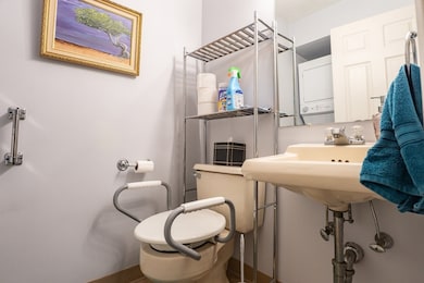
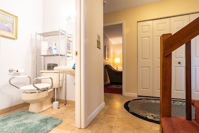
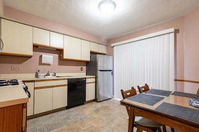
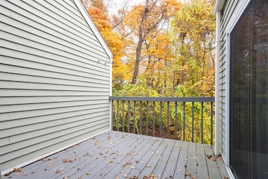
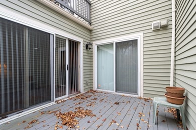
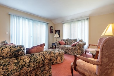
Welcome to Weatherstone at Blithewood! This spacious condo offers comfort, convenience, and great potential. A welcoming foyer opens to a bright living and dining area with sliders to a private deck overlooking wooded views. The kitchen provides ample workspace, with in-unit laundry and a half bath nearby. Upstairs are two generous bedrooms and two full baths, including a comfortable primary suite. The unfinished walkout basement offers excellent storage. While the unit has not been recently updated, it provides a solid foundation for your personal touch. Enjoy central AC, forced heat, garage access, and use of the association pool. Significant community improvements are scheduled for 2025–2026 new roofs, siding, composite decks, sidewalks, and private road paving making the entire development feel refreshed and nearly new. Low-maintenance living in a sought-after location don’t miss this rare opportunity at Weatherstone!
Townhouse Details
Home Type
- Townhome
Est. Annual Taxes
- $4,056
Year Built
- Built in 1988
HOA Fees
- $469 Monthly HOA Fees
Parking
- 1 Car Garage
Home Design
- Entry on the 1st floor
Interior Spaces
- 1,446 Sq Ft Home
- 3-Story Property
- Ceiling Fan
- Entrance Foyer
- Basement
Kitchen
- Stove
- Range
- Microwave
- Dishwasher
Flooring
- Wall to Wall Carpet
- Laminate
Bedrooms and Bathrooms
- 2 Bedrooms
- Primary bedroom located on second floor
- Soaking Tub
- Separate Shower
Laundry
- Laundry on main level
- Dryer
- Washer
Outdoor Features
- In Ground Pool
- Balcony
Location
- Property is near public transit
- Property is near schools
Utilities
- Forced Air Heating and Cooling System
- Heating System Uses Natural Gas
Listing and Financial Details
- Assessor Parcel Number 1793152
Community Details
Overview
- Association fees include water, sewer, insurance, maintenance structure, road maintenance, ground maintenance, snow removal, trash
- 106 Units
- Near Conservation Area
Amenities
- Medical Services
- Shops
Recreation
- Community Pool
- Park
Pet Policy
- Pets Allowed
Map
Home Values in the Area
Average Home Value in this Area
Tax History
| Year | Tax Paid | Tax Assessment Tax Assessment Total Assessment is a certain percentage of the fair market value that is determined by local assessors to be the total taxable value of land and additions on the property. | Land | Improvement |
|---|---|---|---|---|
| 2025 | $4,056 | $307,500 | $0 | $307,500 |
| 2024 | $4,080 | $296,700 | $0 | $296,700 |
| 2023 | $3,691 | $257,400 | $0 | $257,400 |
| 2022 | $3,463 | $227,700 | $0 | $227,700 |
| 2021 | $3,782 | $232,300 | $0 | $232,300 |
| 2020 | $3,521 | $207,100 | $0 | $207,100 |
| 2019 | $3,989 | $221,600 | $0 | $221,600 |
| 2018 | $3,829 | $202,500 | $0 | $202,500 |
| 2017 | $3,804 | $197,900 | $0 | $197,900 |
| 2016 | $3,871 | $187,800 | $0 | $187,800 |
| 2015 | $3,769 | $187,800 | $0 | $187,800 |
| 2014 | $3,636 | $186,100 | $0 | $186,100 |
Property History
| Date | Event | Price | List to Sale | Price per Sq Ft |
|---|---|---|---|---|
| 11/15/2025 11/15/25 | Pending | -- | -- | -- |
| 10/29/2025 10/29/25 | For Sale | $350,000 | -- | $242 / Sq Ft |
Purchase History
| Date | Type | Sale Price | Title Company |
|---|---|---|---|
| Quit Claim Deed | -- | None Available | |
| Quit Claim Deed | -- | None Available | |
| Deed | $130,000 | -- | |
| Deed | $130,000 | -- |
Mortgage History
| Date | Status | Loan Amount | Loan Type |
|---|---|---|---|
| Previous Owner | $70,900 | No Value Available | |
| Previous Owner | $120,000 | No Value Available |
Source: MLS Property Information Network (MLS PIN)
MLS Number: 73449068
APN: WORC-000034-000031-000232
Disclaimer: Certain information contained herein is derived from information provided by parties other than Homes.com. All information provided is deemed reliable, but is not guaranteed to be accurate and should be independently verified.
![]() The property listing data and information, or the Images, set forth herein were provided to MLS Property Information Network, Inc. from third party sources, including sellers, lessors and public records, and were compiled by MLS Property Information Network, Inc. The property listing data and information, and the Images, are for the personal, non-commercial use of consumers having a good faith interest in purchasing or leasing listed properties of the type displayed to them and may not be used for any purpose other than to identify prospective properties which such consumers may have a good faith interest in purchasing or leasing. MLS Property Information Network, Inc. and its subscribers disclaim any and all representations and warranties as to the accuracy of the property listing data and information, or as to the accuracy of any of the Images, set forth herein.
The property listing data and information, or the Images, set forth herein were provided to MLS Property Information Network, Inc. from third party sources, including sellers, lessors and public records, and were compiled by MLS Property Information Network, Inc. The property listing data and information, and the Images, are for the personal, non-commercial use of consumers having a good faith interest in purchasing or leasing listed properties of the type displayed to them and may not be used for any purpose other than to identify prospective properties which such consumers may have a good faith interest in purchasing or leasing. MLS Property Information Network, Inc. and its subscribers disclaim any and all representations and warranties as to the accuracy of the property listing data and information, or as to the accuracy of any of the Images, set forth herein.
- 11 Margin St
- 1203 Grafton St Unit 38
- 3 Stidsen Way
- 1195 Grafton St Unit 3
- 1201 Grafton St Unit 73
- 1199 Grafton St Unit 93
- 31 Crane St
- 27 A-B Grafton St
- 330 Sunderland Rd Unit 78
- 330 Sunderland Rd Unit 87
- 340 Sunderland Rd Unit 23
- 7 Atlas St
- 270 Sunderland Rd Unit 37
- 270 Sunderland Rd Unit 77
- 270 Sunderland Rd Unit 67
- 11 Maplewood Rd
- 330 Millbury Ave
- 12 Irene Ct
- 11 Westview Ave
- 1 Pineland Ave
