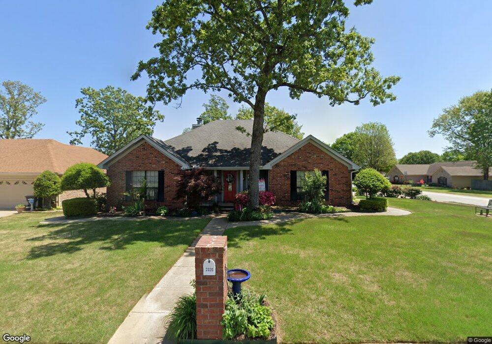
2320 Bearskin Dr Sherwood, AR 72120
Estimated Value: $234,000 - $255,000
--
Bed
2
Baths
1,538
Sq Ft
$162/Sq Ft
Est. Value
About This Home
This home is located at 2320 Bearskin Dr, Sherwood, AR 72120 and is currently estimated at $248,450, approximately $161 per square foot. 2320 Bearskin Dr is a home located in Pulaski County with nearby schools including Clinton Elementary School, Sylvan Hills Middle School, and Sylvan Hills High School.
Ownership History
Date
Name
Owned For
Owner Type
Purchase Details
Closed on
Jan 25, 2010
Sold by
Brooks Debra K
Bought by
Devitt Patrick Todd and Devitt Kymberly Vyctorya
Current Estimated Value
Purchase Details
Closed on
Jun 19, 1998
Sold by
Dewoody Robert M and Dewoody Michelle R
Bought by
Brooks Debra K
Home Financials for this Owner
Home Financials are based on the most recent Mortgage that was taken out on this home.
Original Mortgage
$90,400
Interest Rate
6.61%
Mortgage Type
Purchase Money Mortgage
Purchase Details
Closed on
Mar 27, 1997
Sold by
Dewoody Doyle and Dewoody Barbara J
Bought by
Dewoody Robert M and Dewoody Michelle R
Home Financials for this Owner
Home Financials are based on the most recent Mortgage that was taken out on this home.
Original Mortgage
$24,000
Interest Rate
7.47%
Mortgage Type
Purchase Money Mortgage
Create a Home Valuation Report for This Property
The Home Valuation Report is an in-depth analysis detailing your home's value as well as a comparison with similar homes in the area
Home Values in the Area
Average Home Value in this Area
Purchase History
| Date | Buyer | Sale Price | Title Company |
|---|---|---|---|
| Devitt Patrick Todd | $145,000 | Lenders Title Company | |
| Brooks Debra K | $121,000 | Beach Abstract & Guaranty Co | |
| Dewoody Robert M | -- | -- |
Source: Public Records
Mortgage History
| Date | Status | Borrower | Loan Amount |
|---|---|---|---|
| Previous Owner | Brooks Debra K | $90,400 | |
| Previous Owner | Dewoody Robert M | $24,000 |
Source: Public Records
Tax History Compared to Growth
Tax History
| Year | Tax Paid | Tax Assessment Tax Assessment Total Assessment is a certain percentage of the fair market value that is determined by local assessors to be the total taxable value of land and additions on the property. | Land | Improvement |
|---|---|---|---|---|
| 2025 | $2,103 | $40,372 | $5,800 | $34,572 |
| 2024 | $2,064 | $40,372 | $5,800 | $34,572 |
| 2023 | $2,064 | $40,372 | $5,800 | $34,572 |
| 2022 | $2,102 | $40,372 | $5,800 | $34,572 |
| 2021 | $1,877 | $33,020 | $6,030 | $26,990 |
| 2020 | $1,870 | $33,020 | $6,030 | $26,990 |
| 2019 | $1,870 | $33,020 | $6,030 | $26,990 |
| 2018 | $1,870 | $33,020 | $6,030 | $26,990 |
| 2017 | $1,870 | $33,020 | $6,030 | $26,990 |
| 2016 | $1,911 | $33,800 | $5,200 | $28,600 |
| 2015 | $1,717 | $33,800 | $5,200 | $28,600 |
| 2014 | $1,717 | $32,549 | $5,200 | $27,349 |
Source: Public Records
Map
Nearby Homes
- 2226 Bearskin Dr
- 201 Bearskin Dr
- 2216 Sage Meadows Cir
- 106 Winona Dr
- 7001 Park Meadows Dr
- 2125 Gap Creek Dr
- 7000 Park Meadows Dr
- 6901 Gap Point Cir
- 6813 Gap Point Cir
- 7416 Glenn Hills Dr
- 606 Bay View Ct
- 7112 E Ridge Dr
- 796 Lake Tree Ln
- 2125 Glenn Arbor Ct
- 112 Sugar Maple Dr
- 68 Shoshoni Dr
- 2708 Chert Cove
- 8340 Sapphire Cove
- 6608 Southshore Ln
- 616 Feldspar Dr
- 2314 Bearskin Dr
- 5180 Willow Glen Cir
- 5168 Willow Glen Cir
- 2404 Bearskin Dr
- 2308 Bearskin Dr
- 2321 Bearskin Dr
- 2315 Bearskin Dr
- 4145 Willow Glen Cir
- 5156 Willow Glen Cir
- 2405 Bearskin Dr
- 2410 Bearskin Dr
- 2302 Bearskin Dr
- 2309 Bearskin Dr
- 7104 Briar Glen Cove
- 4133 Willow Glen Cir
- 5085 Willow Glen Cir
- 5144 Willow Glen Cir
- 4084 Willow Glen Cir
- 2411 Bearskin Dr
- 0 Wildberry Cove