C
Seller's Agent in 2016
Cindy G Martins
Re/Max Of Albany
Estimated Value: $250,885 - $340,000
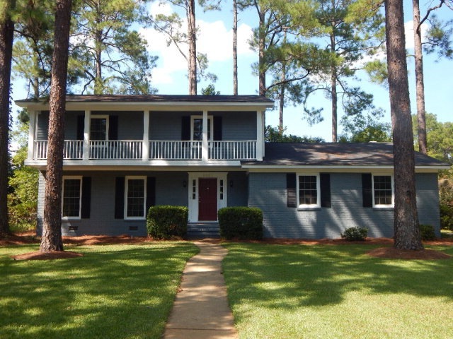
Charm, Character & Space combine in this great Lake Park home! 4 Bedroom, 2.5 Bathroom within walking distance to Lake Park School! Updated kitchen & bathrooms! Wood flooring throughout the foyer, kitchen, dining room, family room & master bedroom - Gorgeous kitchen featuring granite counters, pretty cabinets, stainless appliances, bar seating, breakfast area and a pantry - Dining room w/easy kitchen access - Family room has custom built-ins, fireplace & triple windows that overlook the lush, private backyard - Spacious formal living room - Master bedroom w/private bath & walk-in closet - Bedrooms 2, 3 & 4 are good size with nice closet space - Plantation blinds throughout - Extend the living outdoors on the open deck and stone patio - Sprinkler system front & back - Wired workshop w/new roof & water access - Alarm system - Crawl space humidity system - Double pane windows - garage w/storage - Termite bond - Seller has this one move in ready! 2321 Pheasant should be your new address!
Last Agent to Sell the Property
Cindy G Martins
Re/Max Of Albany Brokerage Phone: 2294341600 Listed on: 09/23/2016
Last Buyer's Agent
Janice Wester
Coldwell Banker Walden & Kirkland
| Date | Buyer | Sale Price | Title Company |
|---|---|---|---|
| Wells Patrick G | $189,900 | -- | |
| Nix Robert Evan | $167,500 | -- | |
| Culpepper Culpepper M | $95,000 | -- |
| Date | Status | Borrower | Loan Amount |
|---|---|---|---|
| Open | Wells Patrick G | $189,900 | |
| Previous Owner | Nix Robert Evan | $134,000 |
| Date | Event | Price | List to Sale | Price per Sq Ft |
|---|---|---|---|---|
| 11/02/2016 11/02/16 | Sold | $189,900 | -- | $84 / Sq Ft |
| 09/23/2016 09/23/16 | Pending | -- | -- | -- |
| Year | Tax Paid | Tax Assessment Tax Assessment Total Assessment is a certain percentage of the fair market value that is determined by local assessors to be the total taxable value of land and additions on the property. | Land | Improvement |
|---|---|---|---|---|
| 2024 | $2,937 | $63,564 | $12,400 | $51,164 |
| 2023 | $2,030 | $63,564 | $12,400 | $51,164 |
| 2022 | $2,879 | $63,564 | $12,400 | $51,164 |
| 2021 | $2,669 | $63,564 | $12,400 | $51,164 |
| 2020 | $2,675 | $63,564 | $12,400 | $51,164 |
| 2019 | $2,685 | $63,564 | $12,400 | $51,164 |
| 2018 | $2,697 | $63,564 | $12,400 | $51,164 |
| 2017 | $2,594 | $63,564 | $12,400 | $51,164 |
| 2016 | $2,514 | $63,564 | $12,400 | $51,164 |
| 2015 | $2,521 | $63,564 | $12,400 | $51,164 |
| 2014 | $2,633 | $65,124 | $13,960 | $51,164 |
C
Seller's Agent in 2016
Cindy G Martins
Re/Max Of Albany
J
Buyer's Agent in 2016
Janice Wester
Coldwell Banker Walden & Kirkland
Source: Albany Board of REALTORS®
MLS Number: 137047
APN: 0000P-00009-012