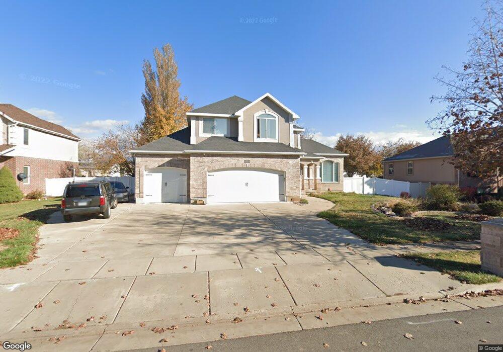
2323 S 550 W Syracuse, UT 84075
Estimated Value: $691,000 - $781,000
4
Beds
4
Baths
4,287
Sq Ft
$171/Sq Ft
Est. Value
About This Home
This home is located at 2323 S 550 W, Syracuse, UT 84075 and is currently estimated at $734,880, approximately $171 per square foot. 2323 S 550 W is a home located in Davis County with nearby schools including Bluff Ridge Elementary, Legacy Junior High School, and Clearfield High School.
Ownership History
Date
Name
Owned For
Owner Type
Purchase Details
Closed on
Aug 3, 2020
Sold by
Black Alan and Black Bianca
Bought by
Black Bianca
Current Estimated Value
Home Financials for this Owner
Home Financials are based on the most recent Mortgage that was taken out on this home.
Original Mortgage
$519,123
Outstanding Balance
$460,324
Interest Rate
3.1%
Mortgage Type
FHA
Estimated Equity
$274,556
Purchase Details
Closed on
Oct 8, 2013
Sold by
Strasser John T and Strasser Catherine A
Bought by
Hadley Trent and Hadley Amy
Home Financials for this Owner
Home Financials are based on the most recent Mortgage that was taken out on this home.
Original Mortgage
$296,910
Interest Rate
4.49%
Mortgage Type
New Conventional
Purchase Details
Closed on
May 12, 2009
Sold by
Strasser John T and Strasser Catherine A
Bought by
Strasser John T and Strasser Catherine A
Home Financials for this Owner
Home Financials are based on the most recent Mortgage that was taken out on this home.
Original Mortgage
$300,000
Interest Rate
4.71%
Mortgage Type
New Conventional
Purchase Details
Closed on
Jul 26, 2006
Sold by
The Non & Barbara Family Trust and Merrill Non M
Bought by
Strasser John T and Jennings Catherine A
Home Financials for this Owner
Home Financials are based on the most recent Mortgage that was taken out on this home.
Original Mortgage
$51,750
Interest Rate
6.76%
Mortgage Type
Stand Alone Second
Purchase Details
Closed on
Sep 14, 2004
Sold by
Merrill Non M and Merrill Barbara H
Bought by
Merrill Non M and Merrill Barbara H
Home Financials for this Owner
Home Financials are based on the most recent Mortgage that was taken out on this home.
Original Mortgage
$235,552
Interest Rate
5.25%
Mortgage Type
New Conventional
Purchase Details
Closed on
May 22, 2003
Sold by
Merrill Non M and Merrill Barbara H
Bought by
Merrill Non M and Merrill Barbara H
Purchase Details
Closed on
Jan 6, 2003
Sold by
Merrill Non M and Merrill Barbara H
Bought by
Merrill Non M and Merrill Barbara H
Home Financials for this Owner
Home Financials are based on the most recent Mortgage that was taken out on this home.
Original Mortgage
$247,200
Interest Rate
5.51%
Purchase Details
Closed on
Apr 10, 2001
Sold by
Merrill Non M and Merrill Barbara H
Bought by
Merrill Non M and Merrill Barbara H
Home Financials for this Owner
Home Financials are based on the most recent Mortgage that was taken out on this home.
Original Mortgage
$244,000
Interest Rate
6.57%
Purchase Details
Closed on
Aug 8, 2000
Sold by
Merrill Non M and Merrill Barbara H
Bought by
Merrill Non M and Merrill Barbara H
Home Financials for this Owner
Home Financials are based on the most recent Mortgage that was taken out on this home.
Original Mortgage
$20,950
Interest Rate
7.94%
Mortgage Type
Stand Alone Second
Purchase Details
Closed on
Dec 29, 1999
Sold by
Merrill Non M and Merrill Barbara H
Bought by
Merrill Non M and Merrill Barbara H
Home Financials for this Owner
Home Financials are based on the most recent Mortgage that was taken out on this home.
Original Mortgage
$242,700
Interest Rate
7.68%
Purchase Details
Closed on
Sep 22, 1998
Sold by
Tbe Investments Llc
Bought by
Build Tech Inc
Create a Home Valuation Report for This Property
The Home Valuation Report is an in-depth analysis detailing your home's value as well as a comparison with similar homes in the area
Home Values in the Area
Average Home Value in this Area
Purchase History
| Date | Buyer | Sale Price | Title Company |
|---|---|---|---|
| Black Bianca | -- | Us Title Company Of | |
| Black Alan | -- | Keystone Title Ins | |
| Hadley Trent | -- | Hickman Land Title Co | |
| Strasser John T | -- | Security Title Of Davis Cnty | |
| Strasser John T | -- | Bonneville Superior Title Co | |
| Merrill Non M | -- | Pinnacle Title | |
| Merrill Non M | -- | Pinnacle Title | |
| Merrill Non M | -- | First American Title Co | |
| Merrill Non M | -- | First American Title Co | |
| Merrill Non M | -- | First American Title Co | |
| Merrill Non M | -- | Bonneville Title Company Inc | |
| Merrill Non M | -- | Bonneville Title Company Inc | |
| Merrill Non M | -- | Mountain View Title & Escrow | |
| Merrill Non M | -- | Mountain View Title & Escrow | |
| Merrill Non M | -- | Mountain West Title & Escrow | |
| Merrill Non M | -- | Mountain View Title & Escrow | |
| Build Tech Inc | -- | Bonneville Title Company Inc |
Source: Public Records
Mortgage History
| Date | Status | Borrower | Loan Amount |
|---|---|---|---|
| Open | Black Alan | $519,123 | |
| Previous Owner | Hadley Trent | $296,910 | |
| Previous Owner | Strasser John T | $300,000 | |
| Previous Owner | Strasser John T | $51,750 | |
| Previous Owner | Strasser John T | $276,000 | |
| Previous Owner | Merrill Non M | $235,552 | |
| Previous Owner | Merrill Non M | $247,200 | |
| Previous Owner | Merrill Non M | $244,000 | |
| Previous Owner | Merrill Non M | $20,950 | |
| Previous Owner | Merrill Non M | $242,700 |
Source: Public Records
Tax History Compared to Growth
Tax History
| Year | Tax Paid | Tax Assessment Tax Assessment Total Assessment is a certain percentage of the fair market value that is determined by local assessors to be the total taxable value of land and additions on the property. | Land | Improvement |
|---|---|---|---|---|
| 2025 | $3,705 | $357,500 | $127,953 | $229,547 |
| 2024 | $3,533 | $343,200 | $108,737 | $234,463 |
| 2023 | $3,588 | $635,000 | $151,343 | $483,657 |
| 2022 | $3,866 | $375,100 | $86,715 | $288,385 |
| 2021 | $3,369 | $506,000 | $128,479 | $377,521 |
| 2020 | $2,874 | $418,000 | $110,452 | $307,548 |
| 2019 | $2,793 | $401,000 | $109,759 | $291,241 |
| 2018 | $2,814 | $401,000 | $105,034 | $295,966 |
| 2016 | $2,439 | $182,270 | $40,248 | $142,022 |
| 2015 | $2,482 | $176,660 | $40,248 | $136,412 |
| 2014 | $2,412 | $174,920 | $40,248 | $134,672 |
| 2013 | -- | $156,000 | $38,213 | $117,787 |
Source: Public Records
Map
Nearby Homes