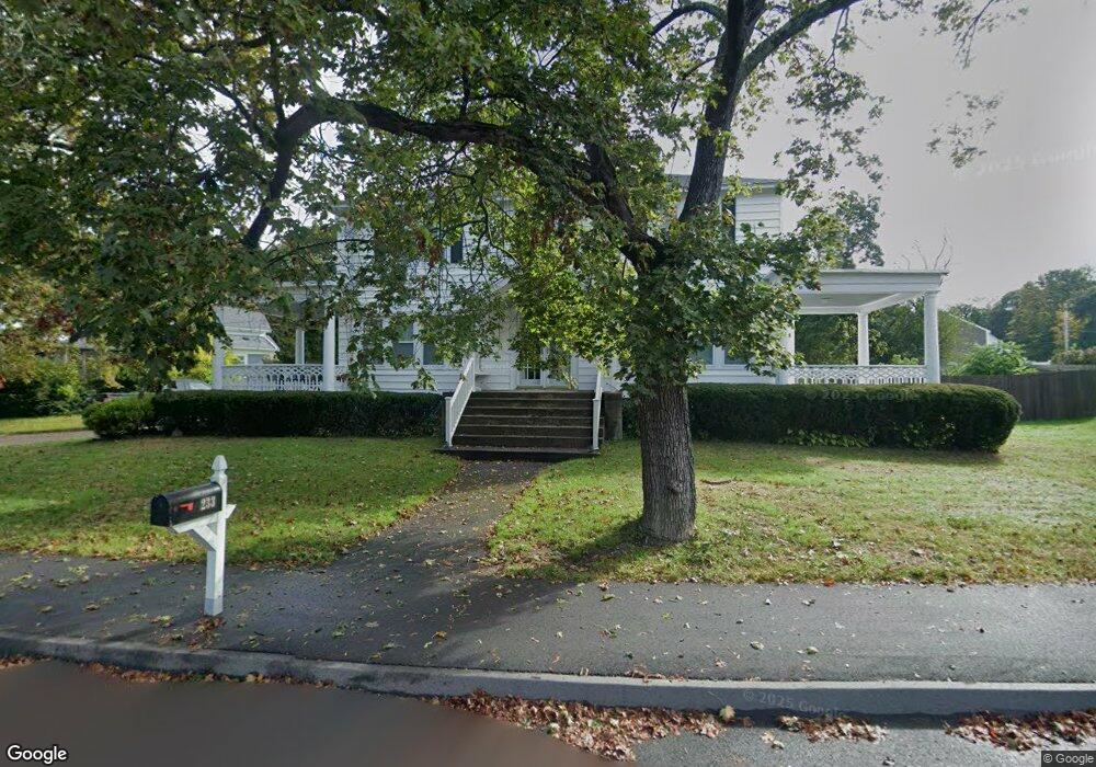
233 Andrews St North Dighton, MA 02764
Estimated Value: $521,386 - $581,000
3
Beds
2
Baths
2,102
Sq Ft
$265/Sq Ft
Est. Value
About This Home
This home is located at 233 Andrews St, North Dighton, MA 02764 and is currently estimated at $556,097, approximately $264 per square foot. 233 Andrews St is a home located in Bristol County with nearby schools including Dighton-Rehoboth Regional High School and Our Lady of Lourdes School.
Ownership History
Date
Name
Owned For
Owner Type
Purchase Details
Closed on
Oct 30, 2017
Sold by
Noble Michele L and Pearce Dabit T
Bought by
Pearce David T and Pearce Michele L
Current Estimated Value
Home Financials for this Owner
Home Financials are based on the most recent Mortgage that was taken out on this home.
Original Mortgage
$181,000
Outstanding Balance
$97,213
Interest Rate
3.78%
Mortgage Type
New Conventional
Estimated Equity
$458,884
Purchase Details
Closed on
Mar 3, 2006
Sold by
Bowen Milton E and Smith Maureen
Bought by
Pearce David T and Noble Michele L
Home Financials for this Owner
Home Financials are based on the most recent Mortgage that was taken out on this home.
Original Mortgage
$220,000
Interest Rate
6.16%
Mortgage Type
Purchase Money Mortgage
Create a Home Valuation Report for This Property
The Home Valuation Report is an in-depth analysis detailing your home's value as well as a comparison with similar homes in the area
Home Values in the Area
Average Home Value in this Area
Purchase History
| Date | Buyer | Sale Price | Title Company |
|---|---|---|---|
| Pearce David T | -- | -- | |
| Pearce David T | $275,000 | -- | |
| Pearce David T | -- | -- | |
| Pearce David T | $275,000 | -- |
Source: Public Records
Mortgage History
| Date | Status | Borrower | Loan Amount |
|---|---|---|---|
| Open | Pearce David T | $181,000 | |
| Closed | Pearce David T | $181,000 | |
| Previous Owner | Pearce David T | $214,000 | |
| Previous Owner | Pearce David T | $220,000 |
Source: Public Records
Tax History Compared to Growth
Tax History
| Year | Tax Paid | Tax Assessment Tax Assessment Total Assessment is a certain percentage of the fair market value that is determined by local assessors to be the total taxable value of land and additions on the property. | Land | Improvement |
|---|---|---|---|---|
| 2025 | $5,315 | $423,200 | $116,000 | $307,200 |
| 2024 | $5,257 | $384,300 | $116,000 | $268,300 |
| 2023 | $4,970 | $356,500 | $116,000 | $240,500 |
| 2022 | $4,753 | $332,600 | $112,500 | $220,100 |
| 2021 | $4,502 | $303,600 | $101,900 | $201,700 |
| 2020 | $4,464 | $298,000 | $113,900 | $184,100 |
| 2019 | $4,152 | $277,000 | $113,900 | $163,100 |
| 2018 | $3,271 | $258,700 | $96,600 | $162,100 |
| 2017 | $3,674 | $245,900 | $112,400 | $133,500 |
| 2016 | $3,657 | $240,100 | $115,800 | $124,300 |
| 2015 | $3,491 | $235,900 | $119,200 | $116,700 |
| 2014 | $3,492 | $229,300 | $119,200 | $110,100 |
Source: Public Records
Map
Nearby Homes
- 0 Andrews St
- 238 Andrews St
- 698 School St Unit 698
- 221 Summer St
- 0 Summer St
- 233-R Summer St
- 876 Autumn St
- 343 Forest St
- 810 Tremont St
- 441 Forest St
- 1472 Somerset Ave
- 1026 Tremont St
- 322 Dighton Ave
- 15 Shetland Rd
- 154 Appaloosa Way
- 969 Somerset Ave
- 410 Warner Blvd Unit A
- 58 Lawton St
- 38 Cranesbill Rd
- 4 A Lawton St Unit A