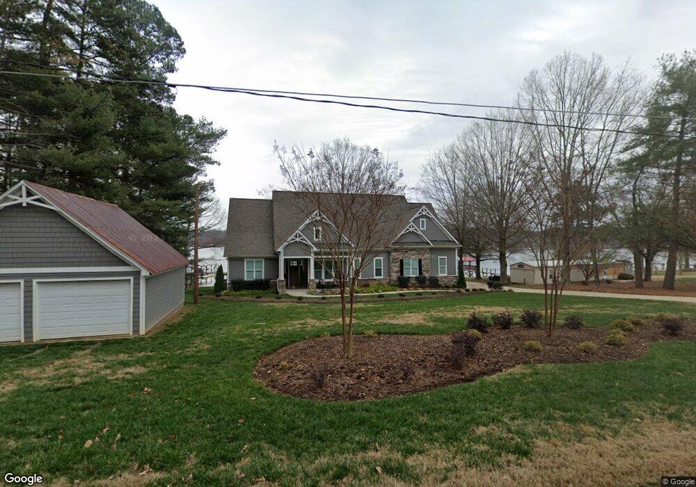
233 Apache Rd Troutman, NC 28166
Estimated Value: $1,006,000 - $1,338,000
3
Beds
2
Baths
1,352
Sq Ft
$875/Sq Ft
Est. Value
About This Home
This home is located at 233 Apache Rd, Troutman, NC 28166 and is currently estimated at $1,182,467, approximately $874 per square foot. 233 Apache Rd is a home located in Iredell County with nearby schools including Troutman Elementary School, Troutman Middle School, and South Iredell High School.
Ownership History
Date
Name
Owned For
Owner Type
Purchase Details
Closed on
May 18, 2017
Sold by
Wilkinson Donald R and Wilkinson Barbara C
Bought by
Heer Robert M and Heer Regina
Current Estimated Value
Home Financials for this Owner
Home Financials are based on the most recent Mortgage that was taken out on this home.
Original Mortgage
$382,500
Outstanding Balance
$316,571
Interest Rate
4.1%
Mortgage Type
New Conventional
Estimated Equity
$865,896
Purchase Details
Closed on
May 1, 1993
Purchase Details
Closed on
Jun 1, 1978
Purchase Details
Closed on
Jun 1, 1976
Create a Home Valuation Report for This Property
The Home Valuation Report is an in-depth analysis detailing your home's value as well as a comparison with similar homes in the area
Home Values in the Area
Average Home Value in this Area
Purchase History
| Date | Buyer | Sale Price | Title Company |
|---|---|---|---|
| Heer Robert M | $425,000 | None Available | |
| -- | $152,500 | -- | |
| -- | $35,000 | -- | |
| -- | $7,500 | -- |
Source: Public Records
Mortgage History
| Date | Status | Borrower | Loan Amount |
|---|---|---|---|
| Open | Heer Robert M | $382,500 |
Source: Public Records
Tax History
| Year | Tax Paid | Tax Assessment Tax Assessment Total Assessment is a certain percentage of the fair market value that is determined by local assessors to be the total taxable value of land and additions on the property. | Land | Improvement |
|---|---|---|---|---|
| 2025 | $6,295 | $1,039,120 | $450,000 | $589,120 |
| 2024 | $6,295 | $1,039,120 | $450,000 | $589,120 |
| 2023 | $6,295 | $1,039,120 | $450,000 | $589,120 |
| 2022 | $4,834 | $748,890 | $300,000 | $448,890 |
| 2021 | $4,755 | $748,890 | $300,000 | $448,890 |
| 2020 | $4,581 | $721,040 | $300,000 | $421,040 |
| 2019 | $2,113 | $341,440 | $300,000 | $41,440 |
| 2018 | $2,106 | $343,830 | $300,000 | $43,830 |
| 2017 | $2,106 | $343,830 | $300,000 | $43,830 |
| 2016 | $2,106 | $343,830 | $300,000 | $43,830 |
| 2015 | $2,106 | $343,830 | $300,000 | $43,830 |
| 2014 | $2,010 | $355,920 | $300,000 | $55,920 |
Source: Public Records
Map
Nearby Homes
- 232 Apache Rd
- 236 Apache Rd
- 307 Stillwater Rd
- 172 Tennessee Cir
- 106 Dayvault Cut Rd
- 406 Morrison Farm Rd
- 170 Silver Falls Dr
- 106 Anchor Ln
- L4 Marietta Rd
- 110 Captains Way
- 000 Spring Oaks Dr
- 512 Stillwater Rd
- 152 Fox Hunt Dr
- 152 Fox Hunt Dr Unit 5
- 107 Kenway Loop
- 175 Abington Ln
- 433 Lockhard Cir
- 110 Emmaline Ct
- 124 Bentley Ct Unit 6
- 570 Morrison Farm Rd
- 239 Apache Rd
- 223 Apache Rd
- 249 Apache Rd
- 255 Apache Rd
- 250 Apache Rd
- 124 Dawn Ln
- Lot #13 Apache Rd Unit 13
- 252 Apache Rd
- 263 Apache Rd
- 258 Apache Rd
- 132 Dawn Ln
- 1011 Twin Coves Ct Unit 1011
- 200 Apache Rd
- 09 Twin Coves Ct Unit 9
- 09 Twin Coves Ct
- 136 Dawn Ln
- 147 Lively Ln
- 0 Crown Ct
- 10 Twin Coves Ct Unit 10
- 10 Twin Coves Ct
Your Personal Tour Guide
Ask me questions while you tour the home.