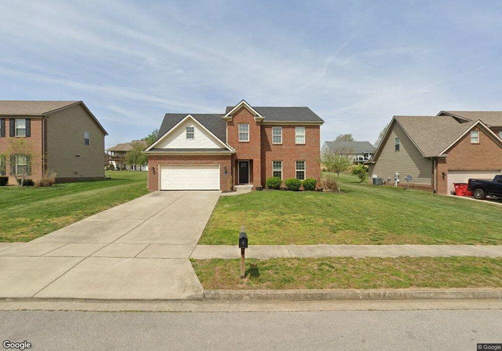
233 Curtis-Ford Trace Nicholasville, KY 40356
South Nicholasville NeighborhoodEstimated Value: $336,366 - $397,000
4
Beds
3
Baths
2,252
Sq Ft
$161/Sq Ft
Est. Value
About This Home
This home is located at 233 Curtis-Ford Trace, Nicholasville, KY 40356 and is currently estimated at $361,592, approximately $160 per square foot. 233 Curtis-Ford Trace is a home located in Jessamine County with nearby schools including Warner Elementary School, East Jessamine Middle School, and East Jessamine High School.
Ownership History
Date
Name
Owned For
Owner Type
Purchase Details
Closed on
Aug 3, 2022
Sold by
Marlinrob Inc
Bought by
Schroeder Tyler Joseph and Schroeder Katlyn Elizabeth
Current Estimated Value
Purchase Details
Closed on
Jul 6, 2016
Sold by
Lpw Re Development Llc
Bought by
Marlinrob Inc
Home Financials for this Owner
Home Financials are based on the most recent Mortgage that was taken out on this home.
Original Mortgage
$152,000
Interest Rate
3.66%
Mortgage Type
Credit Line Revolving
Create a Home Valuation Report for This Property
The Home Valuation Report is an in-depth analysis detailing your home's value as well as a comparison with similar homes in the area
Home Values in the Area
Average Home Value in this Area
Purchase History
| Date | Buyer | Sale Price | Title Company |
|---|---|---|---|
| Schroeder Tyler Joseph | $448,600 | Bluegrass Land Title | |
| Schroeder Tyler Joseph | $448,600 | Bluegrass Land Title | |
| Marlinrob Inc | $24,000 | None Available |
Source: Public Records
Mortgage History
| Date | Status | Borrower | Loan Amount |
|---|---|---|---|
| Previous Owner | Marlinrob Inc | $152,000 |
Source: Public Records
Tax History Compared to Growth
Tax History
| Year | Tax Paid | Tax Assessment Tax Assessment Total Assessment is a certain percentage of the fair market value that is determined by local assessors to be the total taxable value of land and additions on the property. | Land | Improvement |
|---|---|---|---|---|
| 2024 | $2,067 | $196,500 | $27,100 | $169,400 |
| 2023 | $2,087 | $196,500 | $27,100 | $169,400 |
| 2022 | $324 | $174,000 | $24,000 | $150,000 |
| 2021 | $324 | $174,000 | $24,000 | $150,000 |
| 2020 | $324 | $174,000 | $24,000 | $150,000 |
| 2019 | $324 | $174,000 | $24,000 | $150,000 |
| 2018 | $361 | $194,000 | $24,000 | $170,000 |
| 2017 | $361 | $194,000 | $24,000 | $170,000 |
| 2016 | $222 | $22,000 | $22,000 | $0 |
| 2015 | $222 | $22,000 | $22,000 | $0 |
| 2014 | $218 | $22,000 | $22,000 | $0 |
Source: Public Records
Map
Nearby Homes
- 441 Friendly Ave
- 445 Friendly Ave
- 453 Friendly Ave
- 506 Friendly Ave
- 505 Friendly Ave
- 109 Clearwater Dr
- 105 Clearwater Dr
- lot 4 Crawford Creek Dr
- 308 Friendly Ave
- 880 Sulphur Well Pike
- 212 Friendly Ave
- 404 Elam Ave
- 400 Elam Ave
- 312 Elam Ave
- 308 Elam Ave
- 304 Elam Ave
- 300 Elam Ave
- 208 Elam Ave
- 408 Elam Ave
- 613 Williams Rd
- 229 Curtis-Ford Trace
- 237 Curtis Ford Trace
- 128 Dawson Pass
- 225 Curtis-Ford Trace
- 132 Dawson Pass
- 241 Curtis-Ford Trace
- 136 Dawson Pass
- 124 Dawson Pass Unit 2
- 112 Merganser Ct Unit 34
- 100 Merganser Ct Unit 31
- 221 Curtis-Ford Trace
- 120 Dawson Pass
- 140 Dawson Pass
- 240 Curtis-Ford Trace
- 248 Curtis Ford Trace
- 244 Curtis-Ford Trace
- 252 Curtis Ford Trace
- 116 Dawson Pass
- 240 Curtis Ford Trace
- 129 Dawson Pass