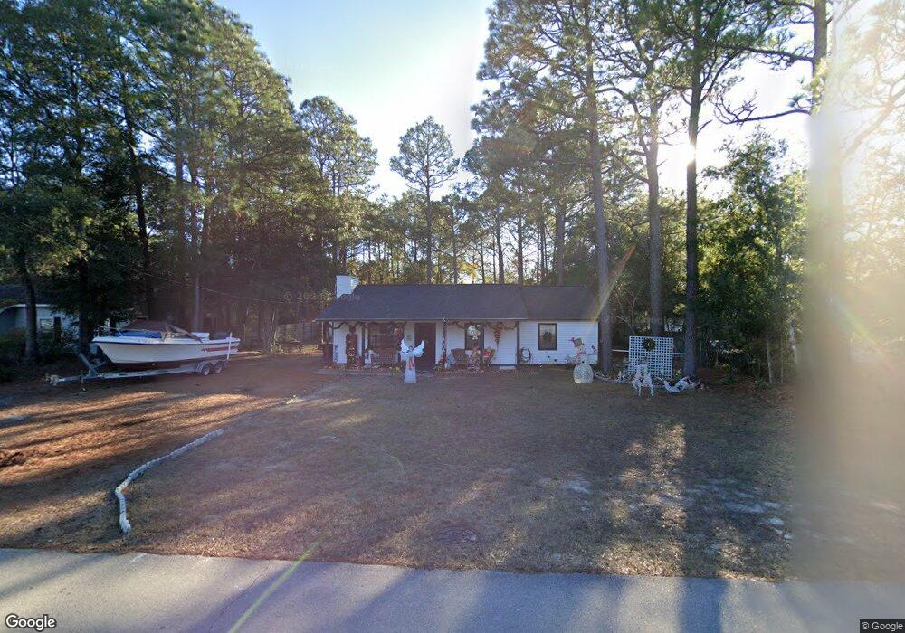
233 E 11th St Unit E Southport, NC 28461
Estimated Value: $342,000 - $374,000
3
Beds
2
Baths
1,128
Sq Ft
$320/Sq Ft
Est. Value
About This Home
This home is located at 233 E 11th St Unit E, Southport, NC 28461 and is currently estimated at $360,670, approximately $319 per square foot. 233 E 11th St Unit E is a home located in Brunswick County with nearby schools including Southport Elementary School, South Brunswick Middle School, and South Brunswick High School.
Ownership History
Date
Name
Owned For
Owner Type
Purchase Details
Closed on
Mar 14, 2019
Sold by
Aversano Gerald P
Bought by
Coleman John Walter and Coleman Kimberly Dawn
Current Estimated Value
Home Financials for this Owner
Home Financials are based on the most recent Mortgage that was taken out on this home.
Original Mortgage
$176,387
Outstanding Balance
$155,074
Interest Rate
4.4%
Mortgage Type
VA
Estimated Equity
$205,596
Purchase Details
Closed on
Jan 13, 2016
Sold by
Gavin Sheila A
Bought by
Aversano Gerald P
Create a Home Valuation Report for This Property
The Home Valuation Report is an in-depth analysis detailing your home's value as well as a comparison with similar homes in the area
Home Values in the Area
Average Home Value in this Area
Purchase History
| Date | Buyer | Sale Price | Title Company |
|---|---|---|---|
| Coleman John Walter | $173,000 | None Available | |
| Aversano Gerald P | -- | None Available |
Source: Public Records
Mortgage History
| Date | Status | Borrower | Loan Amount |
|---|---|---|---|
| Open | Coleman John Walter | $176,387 |
Source: Public Records
Tax History
| Year | Tax Paid | Tax Assessment Tax Assessment Total Assessment is a certain percentage of the fair market value that is determined by local assessors to be the total taxable value of land and additions on the property. | Land | Improvement |
|---|---|---|---|---|
| 2025 | $2,299 | $303,320 | $122,000 | $181,320 |
| 2024 | $22 | $303,320 | $122,000 | $181,320 |
| 2023 | $1,787 | $303,320 | $122,000 | $181,320 |
| 2022 | $1,787 | $172,350 | $75,000 | $97,350 |
| 2021 | $1,552 | $172,350 | $75,000 | $97,350 |
| 2020 | $1,552 | $172,350 | $75,000 | $97,350 |
| 2019 | $1,552 | $75,460 | $75,000 | $460 |
| 2018 | $1,380 | $60,460 | $60,000 | $460 |
| 2017 | $1,368 | $60,460 | $60,000 | $460 |
| 2016 | $1,267 | $60,460 | $60,000 | $460 |
| 2015 | $1,267 | $151,460 | $60,000 | $91,460 |
| 2014 | $1,211 | $152,576 | $65,000 | $87,576 |
Source: Public Records
Map
Nearby Homes
- 811 Memory Ln
- 610 N Fodale Ave
- 110 Highland Park
- 417 E Leonard St
- 1676 N Howe St
- 2031 Oakton Dr
- 2031 Oakton Dr Unit 8
- 139 Stuart Ave
- 2024 Oakton Dr
- 2024 Oakton Dr Unit 15
- 2020 Oakton Dr
- 2020 Oakton Dr Unit 14
- 457 Raven Glen Dr
- 458 Raven Glen Dr
- 415 Raven Glen Dr
- 418 Raven Glen Dr
- 2067 Rosin Dr
- 2067 Rosin Dr Unit 20
- 136 Park Ave
- 1205 N Howe St
- 233 E 11th St
- 231 E 11th St
- 235 E 11th St
- 227 E 11th St
- 616 N Fodale Ave
- 614 N Fodale Ave
- 225 E 11th St
- 225 E 11th St Unit E
- 612 N Fodale Ave
- 232 E 11th St
- 230 E 11th St
- 234 E 11th St
- 228 E 11th St
- 223 E 11th St
- 236 E 11th St
- 0 E 11th St
- 226 E 11th St
- 608 N Fodale Ave
- 224 E 11th St
- 221 E 11thtreet St
Your Personal Tour Guide
Ask me questions while you tour the home.