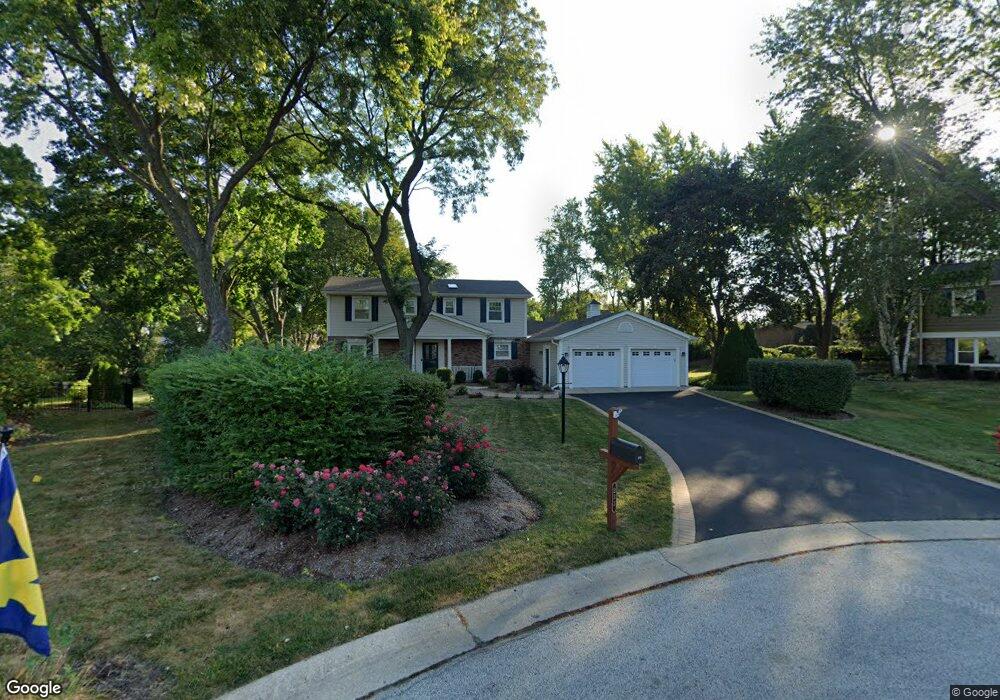
233 Heath Ct Barrington, IL 60010
South Barrington NeighborhoodEstimated Value: $650,000 - $736,000
4
Beds
3
Baths
2,686
Sq Ft
$257/Sq Ft
Est. Value
About This Home
This home is located at 233 Heath Ct, Barrington, IL 60010 and is currently estimated at $690,848, approximately $257 per square foot. 233 Heath Ct is a home located in Cook County with nearby schools including Arnett C. Lines Elementary School, Barrington Middle School Station Campus, and Barrington High School.
Ownership History
Date
Name
Owned For
Owner Type
Purchase Details
Closed on
Oct 20, 2014
Sold by
Ciganek Anthony J
Bought by
Ciganek Anthony J and Anthony J Ciganek 2014 Trust
Current Estimated Value
Purchase Details
Closed on
Dec 3, 1993
Sold by
Rot William J and Rot Marilee R
Bought by
Ciganek Anthony J and Ciganek Kathleen M
Home Financials for this Owner
Home Financials are based on the most recent Mortgage that was taken out on this home.
Original Mortgage
$160,000
Interest Rate
7.31%
Create a Home Valuation Report for This Property
The Home Valuation Report is an in-depth analysis detailing your home's value as well as a comparison with similar homes in the area
Home Values in the Area
Average Home Value in this Area
Purchase History
| Date | Buyer | Sale Price | Title Company |
|---|---|---|---|
| Ciganek Anthony J | -- | None Available | |
| Ciganek Anthony J | $196,666 | -- |
Source: Public Records
Mortgage History
| Date | Status | Borrower | Loan Amount |
|---|---|---|---|
| Previous Owner | Ciganek Anthony J | $160,000 |
Source: Public Records
Tax History Compared to Growth
Tax History
| Year | Tax Paid | Tax Assessment Tax Assessment Total Assessment is a certain percentage of the fair market value that is determined by local assessors to be the total taxable value of land and additions on the property. | Land | Improvement |
|---|---|---|---|---|
| 2024 | $10,080 | $48,000 | $11,647 | $36,353 |
| 2023 | $9,835 | $48,000 | $11,647 | $36,353 |
| 2022 | $9,835 | $48,000 | $11,647 | $36,353 |
| 2021 | $9,980 | $43,279 | $7,117 | $36,162 |
| 2020 | $9,687 | $43,279 | $7,117 | $36,162 |
| 2019 | $9,495 | $47,929 | $7,117 | $40,812 |
| 2018 | $10,858 | $52,289 | $6,470 | $45,819 |
| 2017 | $10,653 | $52,289 | $6,470 | $45,819 |
| 2016 | $10,325 | $52,289 | $6,470 | $45,819 |
| 2015 | $9,853 | $46,486 | $5,823 | $40,663 |
| 2014 | $9,755 | $46,486 | $5,823 | $40,663 |
| 2013 | $9,331 | $46,486 | $5,823 | $40,663 |
Source: Public Records
Map
Nearby Homes
- 110 Tudor Dr
- 129 Roth Ave
- 185 Cold Spring Rd
- 104 Howe Terrace
- 290 Cold Spring Rd
- 101 Surrey Ln
- 523 N Ela Rd
- 104 Lois Ln
- 1312 Lake Shore Dr N Unit 7
- 169 Crestview Ct
- 1288 The Point St
- 175 Hilltop Ave
- 44 Oak Ridge Ln
- 117 Beverly Rd
- 239 Beverly Rd
- 216 Beverly Rd
- 248 Beverly Rd
- 1010 Oakland Dr
- 158 S Ela Rd
- 23455 W Long Grove Rd
- 223 Heath Ct
- 130 Kings Row
- 232 Heath Ct
- 120 Kings Row
- 234 Bellingham Dr
- 140 Kings Row
- 224 Bellingham Dr
- 213 Heath Ct
- 222 Heath Ct
- 244 Bellingham Dr
- 150 Kings Row
- 214 Bellingham Dr
- 212 Heath Ct Unit 2
- 203 Heath Ct
- 231 Wyngate Dr
- 241 Wyngate Dr
- 271 Balmoral Dr
- 221 Wyngate Dr
- 204 Bellingham Dr Unit 2
- 160 Kings Row