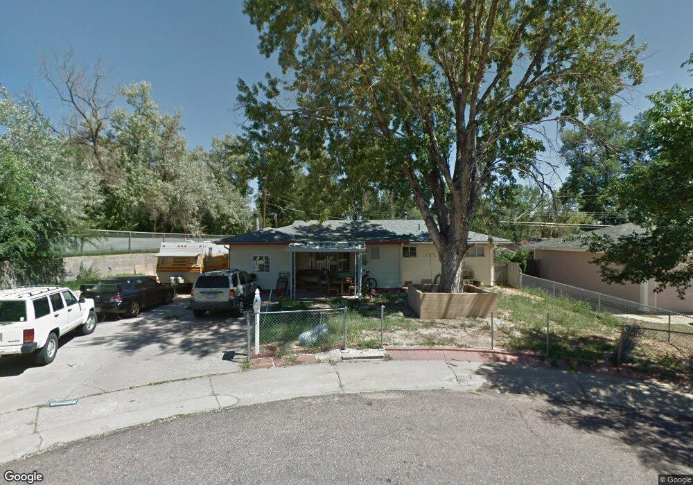
233 Jasper Dr Colorado Springs, CO 80911
Security-Widefield NeighborhoodEstimated Value: $300,970 - $336,000
3
Beds
1
Bath
1,321
Sq Ft
$239/Sq Ft
Est. Value
About This Home
This home is located at 233 Jasper Dr, Colorado Springs, CO 80911 and is currently estimated at $315,743, approximately $239 per square foot. 233 Jasper Dr is a home located in El Paso County with nearby schools including Pinello Elementary School, Sproul Junior High School, and Widefield High School.
Ownership History
Date
Name
Owned For
Owner Type
Purchase Details
Closed on
Nov 5, 2009
Sold by
233 Jasper Llc
Bought by
Nelson Justin D and Nelson Samantha P
Current Estimated Value
Home Financials for this Owner
Home Financials are based on the most recent Mortgage that was taken out on this home.
Original Mortgage
$108,007
Outstanding Balance
$70,632
Interest Rate
5.03%
Mortgage Type
FHA
Estimated Equity
$245,111
Purchase Details
Closed on
Oct 27, 2004
Sold by
Derosa Joseph F
Bought by
233 Jasper Llc
Purchase Details
Closed on
Aug 11, 2004
Sold by
Derosa Joe De
Bought by
233 Jasper Llc
Purchase Details
Closed on
Aug 13, 2003
Sold by
Calhoun Milton W
Bought by
Derosa Joseph F
Purchase Details
Closed on
Aug 30, 2002
Sold by
Derosa Joe
Bought by
233 Jasper Llc
Purchase Details
Closed on
Jun 1, 1998
Sold by
Margaret Padilla
Bought by
Villescas Romie A and Villescas Veronica T
Home Financials for this Owner
Home Financials are based on the most recent Mortgage that was taken out on this home.
Original Mortgage
$91,770
Interest Rate
7.2%
Mortgage Type
FHA
Purchase Details
Closed on
Sep 6, 1996
Sold by
Padilla Joe D
Bought by
Padilla Margaret
Home Financials for this Owner
Home Financials are based on the most recent Mortgage that was taken out on this home.
Original Mortgage
$45,999
Interest Rate
8.24%
Purchase Details
Closed on
Aug 1, 1996
Sold by
Margaret Padilla
Bought by
Padilla Margaret
Home Financials for this Owner
Home Financials are based on the most recent Mortgage that was taken out on this home.
Original Mortgage
$45,999
Interest Rate
8.24%
Purchase Details
Closed on
Nov 15, 1977
Bought by
Nelson Samantha P
Purchase Details
Closed on
Mar 20, 1972
Bought by
Nelson Samantha P
Purchase Details
Closed on
Jul 28, 1965
Bought by
Nelson Samantha P
Purchase Details
Closed on
Oct 25, 1963
Bought by
Nelson Samantha P
Create a Home Valuation Report for This Property
The Home Valuation Report is an in-depth analysis detailing your home's value as well as a comparison with similar homes in the area
Home Values in the Area
Average Home Value in this Area
Purchase History
| Date | Buyer | Sale Price | Title Company |
|---|---|---|---|
| Nelson Justin D | $110,000 | Land Title Guarantee Company | |
| 233 Jasper Llc | -- | -- | |
| 233 Jasper Llc | -- | -- | |
| Derosa Joseph F | $57,500 | -- | |
| Calhoun Milton W | -- | -- | |
| 233 Jasper Llc | -- | -- | |
| Villescas Romie A | $91,500 | Unified Title Co Inc | |
| Padilla Margaret | -- | Stewart Title | |
| Padilla Margaret | -- | -- | |
| Nelson Samantha P | -- | -- | |
| Nelson Samantha P | -- | -- | |
| Nelson Samantha P | -- | -- | |
| Nelson Samantha P | -- | -- |
Source: Public Records
Mortgage History
| Date | Status | Borrower | Loan Amount |
|---|---|---|---|
| Open | Nelson Justin D | $108,007 | |
| Previous Owner | Villescas Romie A | $91,770 | |
| Previous Owner | Padilla Margaret | $45,999 |
Source: Public Records
Tax History Compared to Growth
Tax History
| Year | Tax Paid | Tax Assessment Tax Assessment Total Assessment is a certain percentage of the fair market value that is determined by local assessors to be the total taxable value of land and additions on the property. | Land | Improvement |
|---|---|---|---|---|
| 2025 | $1,388 | $22,490 | -- | -- |
| 2024 | $1,324 | $22,480 | $4,020 | $18,460 |
| 2023 | $1,324 | $22,480 | $4,020 | $18,460 |
| 2022 | $1,032 | $13,830 | $2,780 | $11,050 |
| 2021 | $1,114 | $14,230 | $2,860 | $11,370 |
| 2020 | $790 | $9,810 | $2,500 | $7,310 |
| 2019 | $786 | $9,810 | $2,500 | $7,310 |
| 2018 | $694 | $8,090 | $1,870 | $6,220 |
| 2017 | $702 | $8,090 | $1,870 | $6,220 |
| 2016 | $574 | $8,080 | $1,990 | $6,090 |
| 2015 | $589 | $8,080 | $1,990 | $6,090 |
| 2014 | $555 | $7,650 | $1,790 | $5,860 |
Source: Public Records
Map
Nearby Homes
- 213 Sumac Dr
- 405 Birch Dr
- 324 Davie Dr
- 4790 Hennings Dr
- 217 Steven Dr
- 605 Birch Dr
- 4666 Hennings Dr
- 4658 Hennings Dr
- 105 Larch Dr
- 257 Sherri Dr
- 4634 Cassidy St
- 317 Everett Dr
- 93 Sumac Dr
- 4027 Silver Star Grove
- 96 Davie Dr
- 1604 Rosemont Dr
- 4226 Dooley Way
- 116 Rose Dr
- 4316 Yellow Dock Point
- 4385 Cassidy St