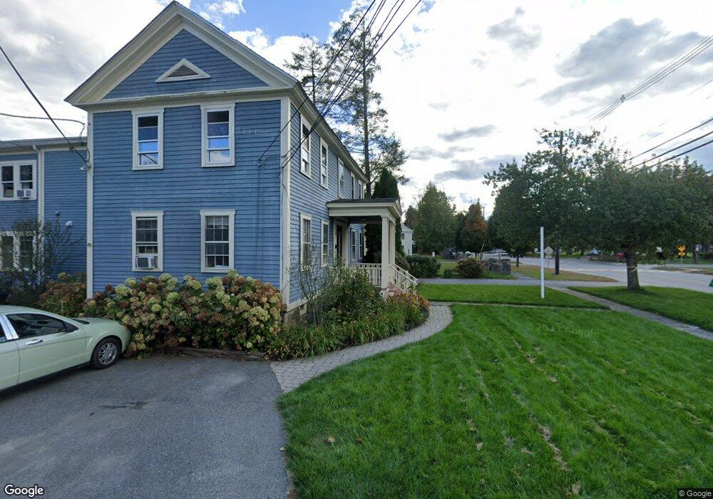
233 Main St Unit 1 1 Lancaster, MA 01523
Estimated Value: $237,816
1
Bed
1
Bath
676
Sq Ft
$352/Sq Ft
Est. Value
About This Home
This home is located at 233 Main St Unit 1 1, Lancaster, MA 01523 and is currently estimated at $237,816, approximately $351 per square foot. 233 Main St Unit 1 1 is a home located in Worcester County with nearby schools including Mary Rowlandson Elementary School, Luther Burbank Middle School, and Nashoba Regional High School.
Ownership History
Date
Name
Owned For
Owner Type
Purchase Details
Closed on
Dec 19, 2007
Sold by
1St Venture T and Forance Michael D
Bought by
Schmitt Carl F and Dillon Thomas M
Current Estimated Value
Home Financials for this Owner
Home Financials are based on the most recent Mortgage that was taken out on this home.
Original Mortgage
$46,000
Outstanding Balance
$29,116
Interest Rate
6.3%
Mortgage Type
Purchase Money Mortgage
Estimated Equity
$208,700
Purchase Details
Closed on
May 15, 1998
Sold by
Murpy Robin M
Bought by
Bowker Richard T and Bowker Susan E
Home Financials for this Owner
Home Financials are based on the most recent Mortgage that was taken out on this home.
Original Mortgage
$45,600
Interest Rate
7.08%
Mortgage Type
Commercial
Create a Home Valuation Report for This Property
The Home Valuation Report is an in-depth analysis detailing your home's value as well as a comparison with similar homes in the area
Home Values in the Area
Average Home Value in this Area
Purchase History
| Date | Buyer | Sale Price | Title Company |
|---|---|---|---|
| Schmitt Carl F | $46,000 | -- | |
| Bowker Richard T | $57,000 | -- | |
| Bowker Richard T | $57,000 | -- |
Source: Public Records
Mortgage History
| Date | Status | Borrower | Loan Amount |
|---|---|---|---|
| Open | Schmitt Carl F | $46,000 | |
| Previous Owner | Bowker Richard T | $45,600 |
Source: Public Records
Tax History Compared to Growth
Tax History
| Year | Tax Paid | Tax Assessment Tax Assessment Total Assessment is a certain percentage of the fair market value that is determined by local assessors to be the total taxable value of land and additions on the property. | Land | Improvement |
|---|---|---|---|---|
| 2025 | $761 | $47,100 | $0 | $47,100 |
| 2024 | $924 | $52,900 | $0 | $52,900 |
| 2023 | $909 | $52,900 | $0 | $52,900 |
| 2022 | $842 | $43,300 | $0 | $43,300 |
| 2021 | $865 | $43,300 | $0 | $43,300 |
| 2020 | $830 | $41,800 | $0 | $41,800 |
| 2019 | $826 | $41,800 | $0 | $41,800 |
| 2018 | $0 | $0 | $0 | $0 |
| 2016 | $770 | $39,400 | $0 | $39,400 |
| 2015 | $739 | $39,400 | $0 | $39,400 |
| 2014 | $677 | $35,800 | $0 | $35,800 |
Source: Public Records
Map
Nearby Homes
- 29 Bennett Ln
- 23 Bennett Ln
- 92 Mill St
- 136 Mill St
- 85 Prescott St
- 132 Kilbourn Rd
- 453 Blue Heron Dr Unit 453
- 0 Parker Rd
- 63 Settlers Path
- 1116 George Hill Rd
- 238 Mill Street Extension
- 201-203 Stone St
- 201 Stone St Unit 203
- 12 Woodruff Rd
- 30 John F. Kennedy Ave
- 22 Forest Ave
- 19 Magnolia Ave
- 920 Ridgefield Cir Unit C
- 921 Ridgefield Cir Unit C
- 405 Ridgefield Cir Unit C
- 17 Kilbourn Rd
- 17 Kilbourn Rd Unit 6
- 15 Kilbourn Rd Unit B
- 15 Kilbourn Rd Unit A
- 15 Kilbourn Rd Unit 4
- 15 Kilbourn Rd Unit 5
- 233 Main St Unit 2R
- 233 Main St Unit 1R
- 233 Main St Unit C1-C2
- 233 Main St Unit 5
- 235 Main St Unit 3
- 235 Main St Unit 2R
- 245 Main St
- 7 Bolton Rd
- 211 Main St Unit 4
- 211 Main St Unit 3
- 41 Kilbourn Rd
- 32 Kilbourn Rd
- 226 Main St Unit 5
- 226 Main St Unit 4