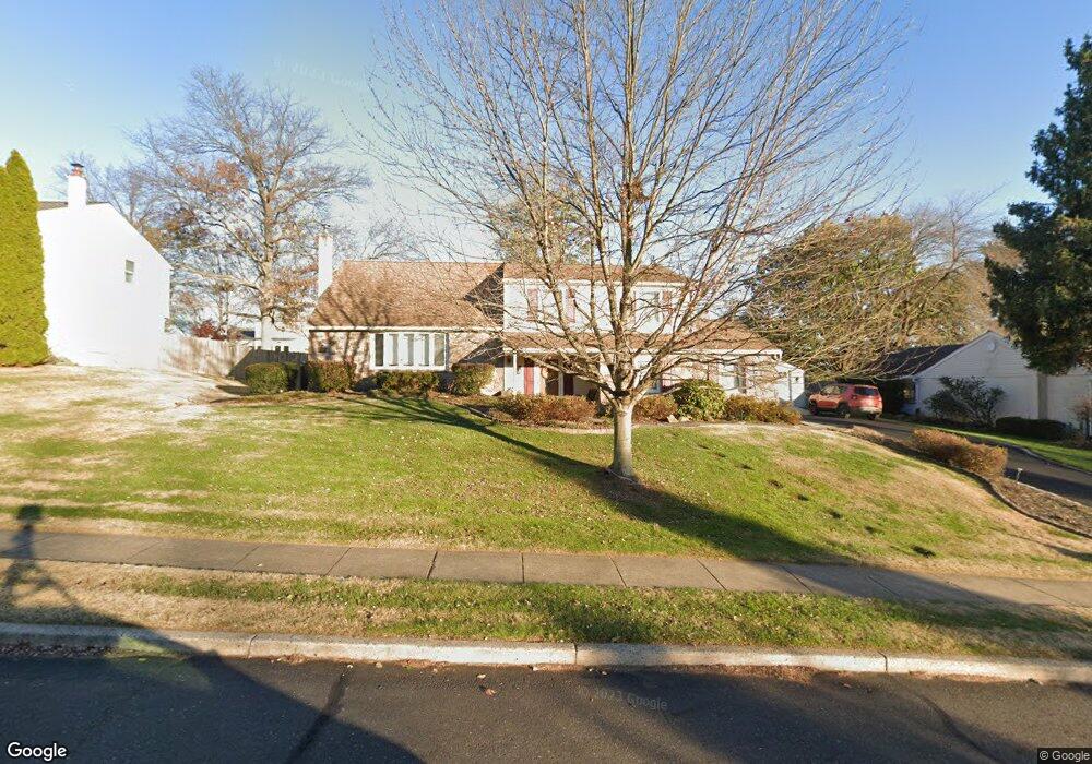
233 N Elm Ave Newtown, PA 18940
Estimated Value: $785,000 - $829,596
3
Beds
3
Baths
1,770
Sq Ft
$453/Sq Ft
Est. Value
About This Home
This home is located at 233 N Elm Ave, Newtown, PA 18940 and is currently estimated at $801,899, approximately $453 per square foot. 233 N Elm Ave is a home located in Bucks County with nearby schools including Goodnoe Elementary School, Newtown Middle School, and Council Rock High School North.
Ownership History
Date
Name
Owned For
Owner Type
Purchase Details
Closed on
Nov 20, 2012
Sold by
Saraullo Catherine E and Dippolito Catherine E
Bought by
Dippolito Kevin T and Dippolito Catherine E
Current Estimated Value
Purchase Details
Closed on
Jul 28, 2003
Sold by
Ulis Albert J and Ulis Carole J
Bought by
Saraullo Catherine E
Home Financials for this Owner
Home Financials are based on the most recent Mortgage that was taken out on this home.
Original Mortgage
$200,000
Outstanding Balance
$88,520
Interest Rate
5.69%
Mortgage Type
Purchase Money Mortgage
Estimated Equity
$713,379
Create a Home Valuation Report for This Property
The Home Valuation Report is an in-depth analysis detailing your home's value as well as a comparison with similar homes in the area
Home Values in the Area
Average Home Value in this Area
Purchase History
| Date | Buyer | Sale Price | Title Company |
|---|---|---|---|
| Dippolito Kevin T | -- | None Available | |
| Saraullo Catherine E | $417,000 | -- |
Source: Public Records
Mortgage History
| Date | Status | Borrower | Loan Amount |
|---|---|---|---|
| Open | Saraullo Catherine E | $200,000 | |
| Closed | Saraullo Catherine E | $99,000 |
Source: Public Records
Tax History Compared to Growth
Tax History
| Year | Tax Paid | Tax Assessment Tax Assessment Total Assessment is a certain percentage of the fair market value that is determined by local assessors to be the total taxable value of land and additions on the property. | Land | Improvement |
|---|---|---|---|---|
| 2025 | $7,225 | $39,510 | $13,280 | $26,230 |
| 2024 | $7,225 | $39,510 | $13,280 | $26,230 |
| 2023 | $6,934 | $39,510 | $13,280 | $26,230 |
| 2022 | $6,934 | $39,510 | $13,280 | $26,230 |
| 2021 | $6,713 | $39,510 | $13,280 | $26,230 |
| 2020 | $6,089 | $36,680 | $13,280 | $23,400 |
| 2019 | $5,935 | $36,680 | $13,280 | $23,400 |
| 2018 | $5,829 | $36,680 | $13,280 | $23,400 |
| 2017 | $5,657 | $36,680 | $13,280 | $23,400 |
| 2016 | $5,657 | $36,680 | $13,280 | $23,400 |
| 2015 | -- | $36,680 | $13,280 | $23,400 |
| 2014 | -- | $36,680 | $13,280 | $23,400 |
Source: Public Records
Map
Nearby Homes
- 101 N Norwood Ave
- 313 Washington Ave
- 144 Yeates Alley
- 215 Rumford Ct
- 206 Paxon Alley Unit 51
- 143 N State St
- 513 Atwood Ct
- 532 Penn St
- 12 Farmington Place
- 113 Penn St
- 3 Farmington Place
- 2 Farmington Place
- 22 Penn St
- 113 Thorton Ln
- 8 Bennington Place
- 226 Court St
- 5 Bolton Cir
- 337 S Lincoln Ave
- 7 Dunham Ln
- 48 Walton Ct