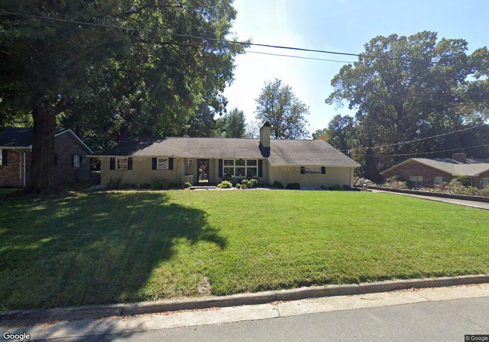
233 Wrenn Ave Mount Airy, NC 27030
Estimated Value: $283,000 - $310,000
3
Beds
3
Baths
2,659
Sq Ft
$112/Sq Ft
Est. Value
About This Home
This home is located at 233 Wrenn Ave, Mount Airy, NC 27030 and is currently estimated at $298,406, approximately $112 per square foot. 233 Wrenn Ave is a home located in Surry County with nearby schools including Bruce H. Tharrington Elementary School, Mount Airy Middle School, and Mount Airy High School.
Ownership History
Date
Name
Owned For
Owner Type
Purchase Details
Closed on
Jun 28, 2013
Sold by
Lowry Scott and Lowry Brooke
Bought by
Johnson Christopher and Johnson Kelly
Current Estimated Value
Home Financials for this Owner
Home Financials are based on the most recent Mortgage that was taken out on this home.
Original Mortgage
$160,000
Outstanding Balance
$114,017
Interest Rate
3.53%
Mortgage Type
New Conventional
Estimated Equity
$184,389
Purchase Details
Closed on
Jun 29, 2007
Sold by
Day Roger T and Day Beth A
Bought by
Lowry Scott F
Home Financials for this Owner
Home Financials are based on the most recent Mortgage that was taken out on this home.
Original Mortgage
$147,250
Interest Rate
6.16%
Mortgage Type
New Conventional
Purchase Details
Closed on
Dec 1, 2004
Purchase Details
Closed on
Oct 1, 2002
Purchase Details
Closed on
Jun 1, 1998
Purchase Details
Closed on
May 1, 1976
Create a Home Valuation Report for This Property
The Home Valuation Report is an in-depth analysis detailing your home's value as well as a comparison with similar homes in the area
Home Values in the Area
Average Home Value in this Area
Purchase History
| Date | Buyer | Sale Price | Title Company |
|---|---|---|---|
| Johnson Christopher | $200,000 | None Available | |
| Lowry Scott F | $155,000 | None Available | |
| -- | $135,000 | -- | |
| -- | -- | -- | |
| -- | $128,000 | -- | |
| -- | -- | -- |
Source: Public Records
Mortgage History
| Date | Status | Borrower | Loan Amount |
|---|---|---|---|
| Open | Johnson Christopher | $160,000 | |
| Previous Owner | Lowry Scott F | $147,250 |
Source: Public Records
Tax History Compared to Growth
Tax History
| Year | Tax Paid | Tax Assessment Tax Assessment Total Assessment is a certain percentage of the fair market value that is determined by local assessors to be the total taxable value of land and additions on the property. | Land | Improvement |
|---|---|---|---|---|
| 2025 | $1,490 | $240,270 | $31,500 | $208,770 |
| 2024 | $1,339 | $195,860 | $31,500 | $164,360 |
| 2023 | $1,317 | $195,860 | $31,500 | $164,360 |
| 2022 | $1,317 | $195,860 | $31,500 | $164,360 |
| 2021 | $1,339 | $195,860 | $31,500 | $164,360 |
| 2020 | $1,294 | $180,520 | $31,500 | $149,020 |
| 2019 | $1,291 | $180,520 | $31,500 | $149,020 |
| 2018 | $1,270 | $180,520 | $0 | $0 |
| 2017 | $1,288 | $180,520 | $0 | $0 |
| 2016 | $1,270 | $180,520 | $0 | $0 |
| 2013 | -- | $156,360 | $0 | $0 |
Source: Public Records
Map
Nearby Homes
- 109 Grace St
- 1709 N Main St Unit A-1
- 1709 N Main St
- 316 Linville Rd
- 344 Linville Rd
- 234 Hylton St
- 0 Woodruff St
- 311 E Lebanon St
- 1694 Woodbury Ln
- 1020 Frank St
- 2029 N Main St
- TBD River Walk Rd
- 1816 Gwyn St
- 921 N South St
- 607 Riverside Dr
- 150 Witt St
- 648 Knollwood Dr
- 1769 Inglebrook Trail
- 643 Willow St
- 712 Greenhill Rd