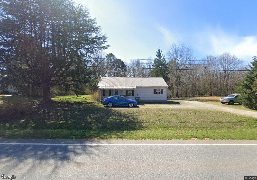
2333 Highway 98 W Danielsville, GA 30633
Estimated Value: $202,842 - $288,000
--
Bed
--
Bath
989
Sq Ft
$249/Sq Ft
Est. Value
About This Home
This home is located at 2333 Highway 98 W, Danielsville, GA 30633 and is currently estimated at $246,461, approximately $249 per square foot. 2333 Highway 98 W is a home with nearby schools including Madison County High School.
Ownership History
Date
Name
Owned For
Owner Type
Purchase Details
Closed on
Apr 7, 2009
Sold by
Dixie Village Inc and Johnson Johnny
Bought by
Dixie Village Inc
Current Estimated Value
Purchase Details
Closed on
Apr 19, 2007
Sold by
Dixie Village Inc
Bought by
Johnson Johnny
Purchase Details
Closed on
May 31, 2006
Sold by
Cronic Patricia
Bought by
Dixie Village Inc
Purchase Details
Closed on
Sep 16, 2005
Sold by
Mcelreath Fred Dwayne
Bought by
Cronic Patricia
Purchase Details
Closed on
Mar 17, 1997
Sold by
Mcelreath Geraldine
Bought by
Strickland Flora Dia
Purchase Details
Closed on
Jan 1, 1988
Bought by
Mcelreath Geraldine
Create a Home Valuation Report for This Property
The Home Valuation Report is an in-depth analysis detailing your home's value as well as a comparison with similar homes in the area
Home Values in the Area
Average Home Value in this Area
Purchase History
| Date | Buyer | Sale Price | Title Company |
|---|---|---|---|
| Dixie Village Inc | -- | -- | |
| Johnson Johnny | $93,750 | -- | |
| Dixie Village Inc | $87,450 | -- | |
| Cronic Patricia | $15,000 | -- | |
| Strickland Flora Dia | -- | -- | |
| Mcelreath Geraldine | -- | -- |
Source: Public Records
Tax History Compared to Growth
Tax History
| Year | Tax Paid | Tax Assessment Tax Assessment Total Assessment is a certain percentage of the fair market value that is determined by local assessors to be the total taxable value of land and additions on the property. | Land | Improvement |
|---|---|---|---|---|
| 2024 | $1,430 | $54,941 | $15,603 | $39,338 |
| 2023 | $1,287 | $49,452 | $13,002 | $36,450 |
| 2022 | $1,131 | $41,011 | $8,939 | $32,072 |
| 2021 | $1,004 | $32,901 | $8,939 | $23,962 |
| 2020 | $971 | $31,601 | $7,639 | $23,962 |
| 2019 | $963 | $30,977 | $7,639 | $23,338 |
| 2018 | $918 | $29,425 | $6,989 | $22,436 |
| 2017 | $837 | $29,080 | $6,501 | $22,579 |
| 2016 | $685 | $23,880 | $5,452 | $18,428 |
| 2015 | $686 | $23,880 | $5,452 | $18,428 |
| 2014 | $697 | $24,114 | $5,550 | $18,564 |
| 2013 | -- | $24,114 | $5,550 | $18,564 |
Source: Public Records
Map
Nearby Homes
- 135 Woodpecker Point
- 135 Woodpecker Pte
- 0 Highway 29 N Unit 10525658
- 0 Brewer Phillips Rd Unit 10462348
- 0 New Haven Church Rd Unit CL334534
- 0 New Haven Church Rd Unit 10566118
- 0 New Haven Church Rd Unit CL334526
- 0 New Haven Church Rd Unit 10566119
- 28 Acres Irvin Kirk Rd
- 155 Mulberry Ln
- 4274 Highway 98 W
- 170 Northridge Dr
- 150 Northridge Dr Unit 3
- 150 Northridge Dr
- 140 Northridge Dr
- 140 Northridge Dr Unit 6
- 112 Northridge Dr Unit 8
- 112 Northridge Dr
- 96 Northridge Dr Unit 10
- 96 Northridge Dr
- 2333 Georgia 98
- 2305 Highway 98 W
- 2277 Highway 98 W
- 2359 Highway 98 W
- Lot 12 the Reserve at Roger's Mill
- Lot 14 the Reserve at Roger's Mill
- Lot 10 the Reserve at Roger's Mill
- Lot 8 the Reserve at Roger's Mill
- Lot 18 the Reserve at Roger's Mill
- Lot 6 the Reserve at Roger's Mill
- Lot 20 the Reserve at Roger's Mill
- Lot 4 the Reserve at Roger's Mill
- Lot 22 the Reserve at Roger's Mill
- 0 the Reserve at Roger's Mill Phase II
- Lot 24 the Reserve at Roger's Mill
- Lot 26 the Reserve at Roger's Mill
- Lot 30 the Reserve at Roger's Mill
- Lot 32 the Reserve at Roger's Mill
- Lot 34 the Reserve at Roger's Mill
- Lot 11 the Reserve at Roger's Mill