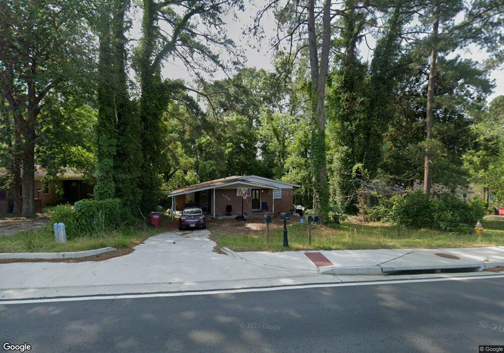
2333 Millerfield Rd Macon, GA 31217
Estimated Value: $79,000 - $117,000
3
Beds
2
Baths
1,215
Sq Ft
$79/Sq Ft
Est. Value
About This Home
This home is located at 2333 Millerfield Rd, Macon, GA 31217 and is currently estimated at $95,901, approximately $78 per square foot. 2333 Millerfield Rd is a home located in Bibb County with nearby schools including Martin Luther King Jr. Elementary School, Appling Middle School, and Northeast High School.
Ownership History
Date
Name
Owned For
Owner Type
Purchase Details
Closed on
Mar 18, 2009
Sold by
Suntrust Bank
Bought by
Bartram Properties Llc
Current Estimated Value
Purchase Details
Closed on
Oct 2, 2007
Sold by
Hill Wanda L
Bought by
Suntrust Bank
Purchase Details
Closed on
Aug 8, 1997
Create a Home Valuation Report for This Property
The Home Valuation Report is an in-depth analysis detailing your home's value as well as a comparison with similar homes in the area
Home Values in the Area
Average Home Value in this Area
Purchase History
| Date | Buyer | Sale Price | Title Company |
|---|---|---|---|
| Bartram Properties Llc | $8,750 | None Available | |
| Suntrust Bank | $38,116 | None Available | |
| -- | $46,000 | -- |
Source: Public Records
Tax History Compared to Growth
Tax History
| Year | Tax Paid | Tax Assessment Tax Assessment Total Assessment is a certain percentage of the fair market value that is determined by local assessors to be the total taxable value of land and additions on the property. | Land | Improvement |
|---|---|---|---|---|
| 2025 | $695 | $28,294 | $2,880 | $25,414 |
| 2024 | $719 | $28,294 | $2,880 | $25,414 |
| 2023 | $719 | $28,294 | $2,880 | $25,414 |
| 2022 | $646 | $18,656 | $1,858 | $16,798 |
| 2021 | $522 | $13,748 | $1,239 | $12,509 |
| 2020 | $456 | $11,754 | $1,032 | $10,722 |
| 2019 | $460 | $11,754 | $1,032 | $10,722 |
| 2018 | $885 | $11,754 | $1,032 | $10,722 |
| 2017 | $440 | $11,754 | $1,032 | $10,722 |
| 2016 | $408 | $11,797 | $1,032 | $10,764 |
| 2015 | $595 | $12,141 | $1,376 | $10,764 |
| 2014 | $722 | $12,829 | $2,064 | $10,764 |
Source: Public Records
Map
Nearby Homes
- 2229 New Clinton Rd
- 2130 New Clinton Rd
- 2146 Melton Ave
- 2066 Melton Ave
- 2370 Recreation Rd
- 1840 Kinder Kare Dr
- 1818 Kinder Kare Dr
- 875 Artic Cir
- 837 Artic Cir
- 2675 Andy Dr
- 875 Artic Place
- 4436 Jeffersonville Rd
- 2720 Jordan Ave
- 860 Morningside Dr
- 2954 Tyler Place
- 2792 Skyline Dr
- 909 Johnson St
- 2458 Tredway Dr
- 2630 Pauladale Dr
- 2371 Kensington Rd
- 2343 Millerfield Rd
- 2325 Millerfield Rd
- 2315 Millerfield Rd
- 2349 Millerfield Rd
- 2312 Danbury Dr
- 2326 Danbury Dr
- 2328 Millerfield Rd
- 2320 Millerfield Rd
- 2357 Millerfield Rd
- 2304 Danbury Dr
- 2332 Danbury Dr
- 2302 Bristol Dr
- 2322 Bristol Dr
- 2361 Millerfield Rd
- 2308 Millerfield Rd
- 2334 Millerfield Rd
- 2340 Danbury Dr
- 2340 Millerfield Rd
- 2348 Bristol Dr
- 2369 Millerfield Rd