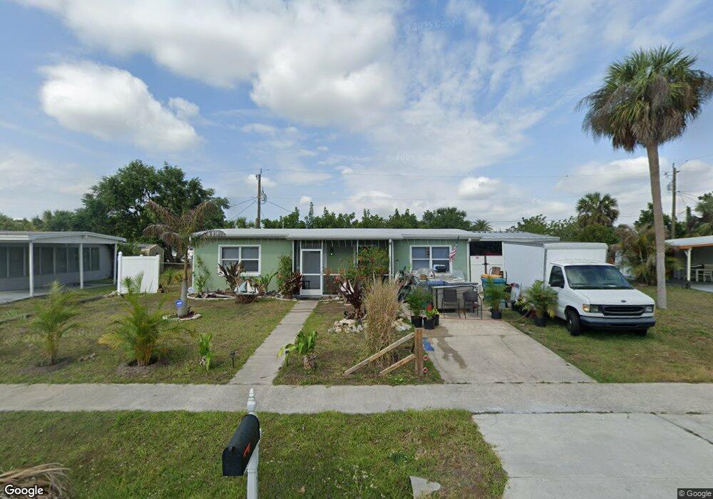
2337 Wiley St Port Charlotte, FL 33952
Estimated Value: $117,000 - $160,000
2
Beds
2
Baths
682
Sq Ft
$215/Sq Ft
Est. Value
About This Home
This home is located at 2337 Wiley St, Port Charlotte, FL 33952 and is currently estimated at $146,629, approximately $214 per square foot. 2337 Wiley St is a home located in Charlotte County with nearby schools including Peace River Elementary School, Port Charlotte Middle School, and Port Charlotte High School.
Ownership History
Date
Name
Owned For
Owner Type
Purchase Details
Closed on
Apr 15, 2025
Sold by
Ehleiter Ellen L and Haaland Family Trust
Bought by
Knutson Rory
Current Estimated Value
Purchase Details
Closed on
Feb 6, 2014
Sold by
Haaland Ellen L and Ehleiter Ellen L
Bought by
Haaland Family Trust
Purchase Details
Closed on
Apr 26, 1999
Sold by
Barron Muriel G
Bought by
Ehleiter Ellen L
Home Financials for this Owner
Home Financials are based on the most recent Mortgage that was taken out on this home.
Original Mortgage
$30,600
Interest Rate
7.06%
Purchase Details
Closed on
Jan 22, 1998
Sold by
Barron Muriel G
Bought by
Barron Muriel G
Purchase Details
Closed on
Dec 30, 1997
Sold by
Barron Muriel G and Wingert Grace F
Bought by
Barron Muriel G
Create a Home Valuation Report for This Property
The Home Valuation Report is an in-depth analysis detailing your home's value as well as a comparison with similar homes in the area
Home Values in the Area
Average Home Value in this Area
Purchase History
| Date | Buyer | Sale Price | Title Company |
|---|---|---|---|
| Knutson Rory | $100 | None Listed On Document | |
| Haaland Family Trust | -- | Attorney | |
| Ehleiter Ellen L | $34,000 | -- | |
| Barron Muriel G | -- | -- | |
| Barron Muriel G | -- | -- |
Source: Public Records
Mortgage History
| Date | Status | Borrower | Loan Amount |
|---|---|---|---|
| Previous Owner | Ehleiter Ellen L | $30,600 |
Source: Public Records
Tax History Compared to Growth
Tax History
| Year | Tax Paid | Tax Assessment Tax Assessment Total Assessment is a certain percentage of the fair market value that is determined by local assessors to be the total taxable value of land and additions on the property. | Land | Improvement |
|---|---|---|---|---|
| 2024 | $1,974 | $123,922 | $18,700 | $105,222 |
| 2023 | $1,974 | $53,651 | $0 | $0 |
| 2022 | $1,852 | $105,204 | $13,600 | $91,604 |
| 2021 | $1,572 | $65,361 | $5,950 | $59,411 |
| 2020 | $1,378 | $46,944 | $4,505 | $42,439 |
| 2019 | $1,277 | $45,706 | $5,015 | $40,691 |
| 2018 | $1,137 | $42,692 | $4,505 | $38,187 |
| 2017 | $1,065 | $35,840 | $3,953 | $31,887 |
| 2016 | $1,006 | $29,531 | $0 | $0 |
| 2015 | $969 | $26,846 | $0 | $0 |
| 2014 | $908 | $24,405 | $0 | $0 |
Source: Public Records
Map
Nearby Homes
- 2321 Dallas St
- 2554 Ambrose Ln
- 21150 Gertrude Ave Unit G3
- 21150 Gertrude Ave Unit 4
- 21150 Gertrude Ave Unit S4
- 21150 Gertrude Ave Unit 1
- 21150 Gertrude Ave Unit O3
- 21150 Gertrude Ave Unit A3
- 2513 Ambrose Ln
- 2433 Ednor St
- 2440 Elkcam Blvd
- 2217 Ednor St
- 21042 Gladis Ave
- 2507 Linton Ln
- 2420 Linton Ln
- 2259 Lee Terrace
- 2267 Lee Terrace
- 2486 Caring Way Unit 14A
- 2486 Caring Way Unit 17A
- 21242 Coulton Ave