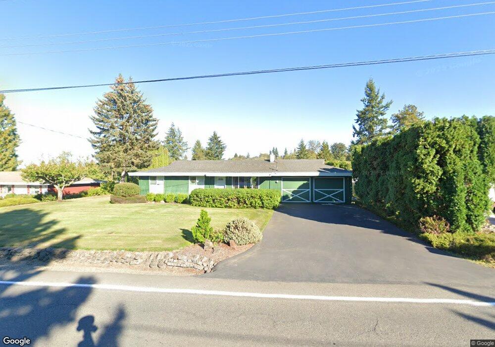
2339 Mitchell Rd SE Port Orchard, WA 98366
East Port Orchard NeighborhoodEstimated Value: $453,000 - $512,000
4
Beds
2
Baths
1,764
Sq Ft
$276/Sq Ft
Est. Value
About This Home
This home is located at 2339 Mitchell Rd SE, Port Orchard, WA 98366 and is currently estimated at $487,415, approximately $276 per square foot. 2339 Mitchell Rd SE is a home located in Kitsap County with nearby schools including East Port Orchard Elementary School, Marcus Whitman Middle School, and South Kitsap High School.
Ownership History
Date
Name
Owned For
Owner Type
Purchase Details
Closed on
Jan 17, 2003
Sold by
Jensen Roger A
Bought by
Jensen Roger A and Jensen Jacquelynn L
Current Estimated Value
Home Financials for this Owner
Home Financials are based on the most recent Mortgage that was taken out on this home.
Original Mortgage
$65,500
Interest Rate
5.96%
Mortgage Type
Purchase Money Mortgage
Create a Home Valuation Report for This Property
The Home Valuation Report is an in-depth analysis detailing your home's value as well as a comparison with similar homes in the area
Home Values in the Area
Average Home Value in this Area
Purchase History
| Date | Buyer | Sale Price | Title Company |
|---|---|---|---|
| Jensen Roger A | -- | Land Title Company |
Source: Public Records
Mortgage History
| Date | Status | Borrower | Loan Amount |
|---|---|---|---|
| Closed | Jensen Roger A | $65,500 |
Source: Public Records
Tax History Compared to Growth
Tax History
| Year | Tax Paid | Tax Assessment Tax Assessment Total Assessment is a certain percentage of the fair market value that is determined by local assessors to be the total taxable value of land and additions on the property. | Land | Improvement |
|---|---|---|---|---|
| 2026 | $3,751 | $464,770 | $77,710 | $387,060 |
| 2025 | $3,751 | $425,680 | $63,750 | $361,930 |
| 2024 | $3,637 | $425,680 | $63,750 | $361,930 |
| 2023 | $3,613 | $425,680 | $63,750 | $361,930 |
| 2022 | $3,539 | $349,420 | $59,540 | $289,880 |
| 2021 | $3,425 | $320,070 | $55,320 | $264,750 |
| 2020 | $3,367 | $305,710 | $52,690 | $253,020 |
| 2019 | $600 | $279,620 | $51,770 | $227,850 |
| 2018 | $2,935 | $225,930 | $51,770 | $174,160 |
| 2017 | $2,506 | $225,930 | $51,770 | $174,160 |
| 2016 | $2,437 | $201,050 | $51,770 | $149,280 |
| 2015 | $2,359 | $197,130 | $51,770 | $145,360 |
| 2014 | -- | $193,200 | $51,770 | $141,430 |
| 2013 | -- | $188,250 | $54,490 | $133,760 |
Source: Public Records
Map
Nearby Homes
- 1350 SE Shelton Ln
- 2673 Harold Dr SE
- 0 Lincoln Ave SE
- 2313 Lincoln Ave SE
- 3132 Harris Rd SE
- 2235 Eisenhower Ave SE
- 2198 SE Galeel Ct
- 1408 West Ave
- 1325 Garrison Ave
- 2360 SE Plymouth Way
- 1234 Garrison Ave
- 2315 SE Kelby Cir
- 410 Kendall St
- 2225 SE Kelby Cir
- 0 Smith St
- 1369 Sherman Ave
- 911 Hull Ave
- 4990 Mile Hill Dr
- 108 Kendall St
- 2949 SE Mile Hill Dr Unit C7
- 2359 Mitchell Rd SE
- 2303 Mitchell Rd SE
- 2379 Mitchell Rd SE
- 2379 Mitchell Ave SE
- 2341 Joslin St SE
- 2271 Mitchell Rd SE
- 2401 Mitchell Rd SE
- 2313 Joslin St SE
- 1827 SE Beck St
- 2362 Mitchell Rd SE
- 1851 SE Beck St
- 2378 Mitchell Rd SE
- 2287 Joslin St SE
- 1801 SE Beck St
- 2247 Mitchell Rd SE
- 2342 Jefferson Ave SE
- 2276 Mitchell Rd SE
- 2314 Jefferson Ave SE
- 2362 Jefferson Ave SE
- 2263 Joslin St SE