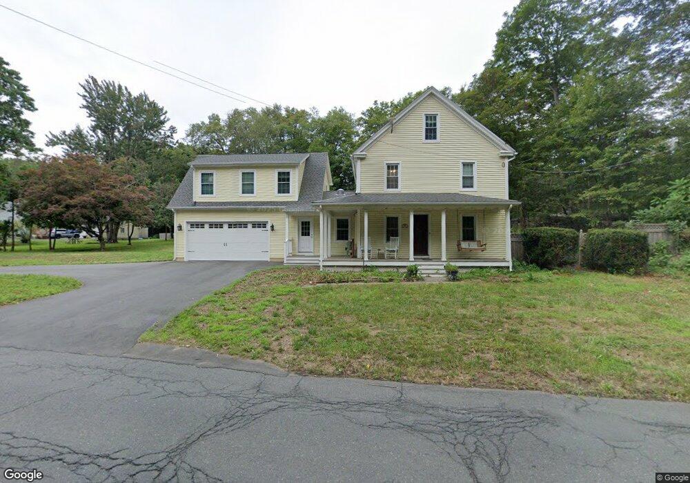
234 Bates Rd Westfield, MA 01085
Estimated Value: $366,000 - $497,000
3
Beds
2
Baths
2,449
Sq Ft
$181/Sq Ft
Est. Value
About This Home
This home is located at 234 Bates Rd, Westfield, MA 01085 and is currently estimated at $443,176, approximately $180 per square foot. 234 Bates Rd is a home located in Hampden County with nearby schools including Westfield High School and Saint Mary High School.
Ownership History
Date
Name
Owned For
Owner Type
Purchase Details
Closed on
Jul 27, 2023
Sold by
Jones Erica L
Bought by
Jones Douglas D
Current Estimated Value
Purchase Details
Closed on
Aug 20, 1999
Sold by
Lurgio Peter M
Bought by
Lurgio Holly E and Jones Douglas D
Home Financials for this Owner
Home Financials are based on the most recent Mortgage that was taken out on this home.
Original Mortgage
$100,000
Interest Rate
7.6%
Mortgage Type
Purchase Money Mortgage
Purchase Details
Closed on
Sep 27, 1996
Sold by
Michaud Ronald N
Bought by
Lurgio Peter M and Lurgio Holly E
Home Financials for this Owner
Home Financials are based on the most recent Mortgage that was taken out on this home.
Original Mortgage
$112,500
Interest Rate
7.83%
Mortgage Type
Purchase Money Mortgage
Create a Home Valuation Report for This Property
The Home Valuation Report is an in-depth analysis detailing your home's value as well as a comparison with similar homes in the area
Home Values in the Area
Average Home Value in this Area
Purchase History
| Date | Buyer | Sale Price | Title Company |
|---|---|---|---|
| Jones Douglas D | -- | None Available | |
| Lurgio Holly E | $138,500 | -- | |
| Lurgio Peter M | $125,000 | -- |
Source: Public Records
Mortgage History
| Date | Status | Borrower | Loan Amount |
|---|---|---|---|
| Previous Owner | Lurgio Peter M | $50,000 | |
| Previous Owner | Lurgio Peter M | $100,000 | |
| Previous Owner | Lurgio Peter M | $112,500 |
Source: Public Records
Tax History Compared to Growth
Tax History
| Year | Tax Paid | Tax Assessment Tax Assessment Total Assessment is a certain percentage of the fair market value that is determined by local assessors to be the total taxable value of land and additions on the property. | Land | Improvement |
|---|---|---|---|---|
| 2025 | $6,139 | $404,400 | $133,900 | $270,500 |
| 2024 | $5,946 | $372,300 | $122,500 | $249,800 |
| 2023 | $5,763 | $339,400 | $116,200 | $223,200 |
| 2022 | $4,310 | $233,100 | $103,800 | $129,300 |
| 2021 | $4,009 | $218,300 | $97,500 | $120,800 |
| 2020 | $4,029 | $209,300 | $97,500 | $111,800 |
| 2019 | $1,634 | $199,200 | $92,800 | $106,400 |
| 2018 | $3,360 | $199,200 | $92,800 | $106,400 |
| 2017 | $3,211 | $197,300 | $94,500 | $102,800 |
| 2016 | $3,836 | $197,300 | $94,500 | $102,800 |
| 2015 | $3,658 | $197,300 | $94,500 | $102,800 |
| 2014 | $2,735 | $197,300 | $94,500 | $102,800 |
Source: Public Records
Map
Nearby Homes
- 66 Stoney Ln
- 1430 Russell Rd Unit 35
- 3 Angelica Dr
- 781 Western Ave
- 36 Patriots Path
- 555 Russell Rd Unit D18
- 549 Russell Rd Unit 6B
- 40 Heritage Ln
- 36 Woodland Way
- 0 Woodland Way
- 508 Granville Rd
- 324 Russell Rd Unit 204
- 52 Simmons Brook Dr
- 291 Pochassic Rd
- 197 Loomis Rg
- 205 Russell Rd
- 53 Yankee Cir
- 0 Fox Hill Dr
- 156 Honey Pot Rd
- 11 Highland Cir
- 233 Bates Rd
- 224 Bates Rd
- 225 Bates Rd
- 1210 Russell Rd
- 12 Northwest Rd
- 00 Northwest Rd
- 0 Northwest Rd
- 18 Northwest Rd
- 220 Bates Rd
- 223 Bates Rd
- 0 N West Rd Unit 71076379
- 0 N West Rd Unit 70612566
- 0 N West Rd Unit 73160363
- 0 N West Rd Unit 70665368
- 0 N West Rd Unit 70665348
- 24 Northwest Rd
- 8 Morningside Dr
- 216 Bates Rd
- 30 Northwest Rd
- 215 Bates Rd