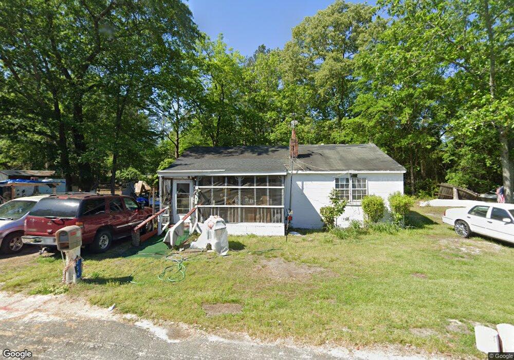
234 Iris St Raeford, NC 28376
Estimated Value: $74,494 - $129,000
Studio
1
Bath
1,120
Sq Ft
$86/Sq Ft
Est. Value
About This Home
This home is located at 234 Iris St, Raeford, NC 28376 and is currently estimated at $95,874, approximately $85 per square foot. 234 Iris St is a home located in Hoke County with nearby schools including Scurlock Elementary School, West Hoke Middle, and Hoke County High.
Ownership History
Date
Name
Owned For
Owner Type
Purchase Details
Closed on
Dec 2, 2016
Sold by
Eloise Upchurch Carter
Bought by
Copeland Norman
Current Estimated Value
Home Financials for this Owner
Home Financials are based on the most recent Mortgage that was taken out on this home.
Original Mortgage
$17,166
Outstanding Balance
$14,061
Interest Rate
4.08%
Estimated Equity
$81,813
Create a Home Valuation Report for This Property
The Home Valuation Report is an in-depth analysis detailing your home's value as well as a comparison with similar homes in the area
Home Values in the Area
Average Home Value in this Area
Purchase History
| Date | Buyer | Sale Price | Title Company |
|---|---|---|---|
| Copeland Norman | -- | -- |
Source: Public Records
Mortgage History
| Date | Status | Borrower | Loan Amount |
|---|---|---|---|
| Open | Copeland Norman | $17,166 | |
| Closed | Copeland Norman | -- |
Source: Public Records
Tax History
| Year | Tax Paid | Tax Assessment Tax Assessment Total Assessment is a certain percentage of the fair market value that is determined by local assessors to be the total taxable value of land and additions on the property. | Land | Improvement |
|---|---|---|---|---|
| 2025 | $678 | $50,370 | $26,400 | $23,970 |
| 2024 | $678 | $50,370 | $26,400 | $23,970 |
| 2023 | $678 | $50,370 | $26,400 | $23,970 |
| 2022 | $670 | $50,370 | $26,400 | $23,970 |
| 2021 | $0 | $32,140 | $11,500 | $20,640 |
| 2020 | $526 | $32,140 | $11,500 | $20,640 |
| 2019 | $526 | $32,140 | $11,500 | $20,640 |
| 2018 | $526 | $32,140 | $11,500 | $20,640 |
| 2017 | $526 | $32,140 | $11,500 | $20,640 |
| 2016 | $521 | $32,140 | $11,500 | $20,640 |
| 2015 | $521 | $32,140 | $11,500 | $20,640 |
| 2014 | $484 | $32,140 | $11,500 | $20,640 |
| 2013 | -- | $29,690 | $9,300 | $20,390 |
Source: Public Records
Map
Nearby Homes
- 241 Oakdale Gin Rd
- 151 Ratley St
- 0 Lot 4 Polaris Ct
- 3 Polaris Ct
- 299 Cape Fear Rd
- 908 E Prospect Ave
- 370 Bulldawg Ln
- 633 Cape Fear Rd
- 259 Roanoke Dr
- 823 E Donaldson Ave
- 125 Lochmere Dr
- 716 Roanoke Dr
- 912 Lewis St
- 298 Turkey Trot Ln
- 134 Edgar Way
- 295 Desert Orchid Cir
- 113 Meherrin Loop
- 240 Meherrin Loop
- 209 E Elwood Ave
- 804 Saunders St
Your Personal Tour Guide
Ask me questions while you tour the home.