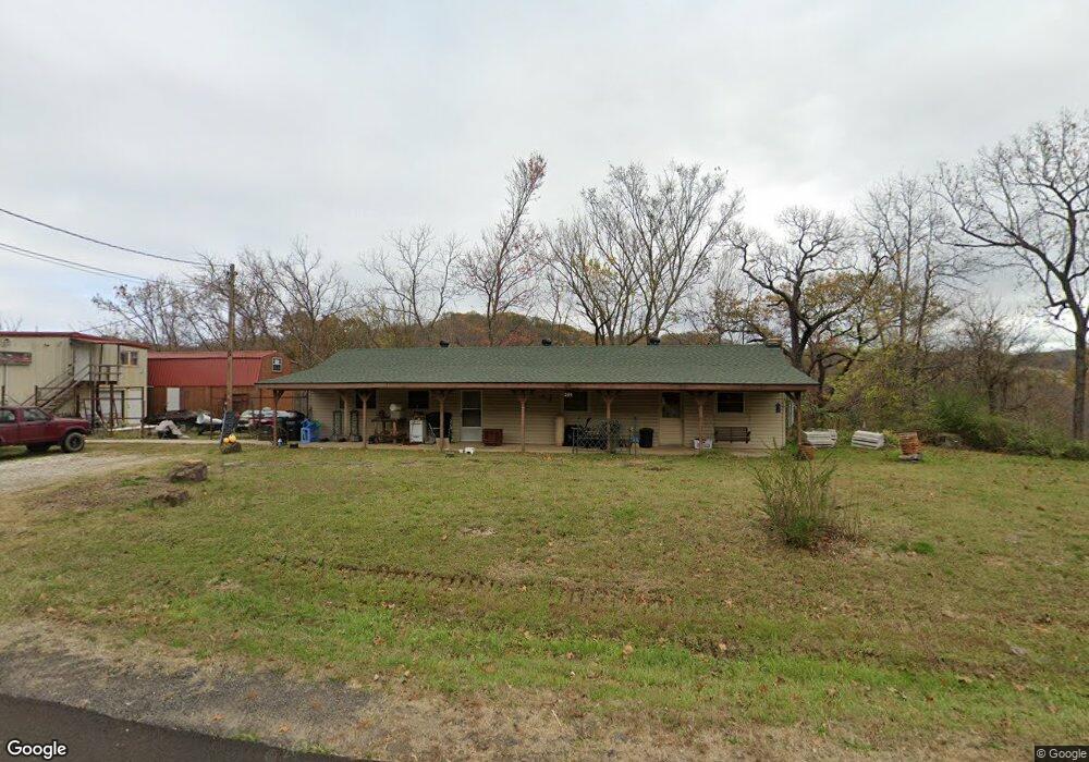
234 S Highway 71 Winslow, AR 72959
Estimated Value: $221,000 - $300,887
--
Bed
2
Baths
2,040
Sq Ft
$126/Sq Ft
Est. Value
About This Home
This home is located at 234 S Highway 71, Winslow, AR 72959 and is currently estimated at $256,972, approximately $125 per square foot. 234 S Highway 71 is a home located in Washington County with nearby schools including Greenland Middle School, Greenland Elementary School, and Greenland High School.
Ownership History
Date
Name
Owned For
Owner Type
Purchase Details
Closed on
Aug 31, 2004
Sold by
Sampson Theodore F and Sampson Dorotha A
Bought by
Barnett Bill A
Current Estimated Value
Home Financials for this Owner
Home Financials are based on the most recent Mortgage that was taken out on this home.
Original Mortgage
$84,110
Outstanding Balance
$41,626
Interest Rate
5.97%
Mortgage Type
VA
Estimated Equity
$215,346
Purchase Details
Closed on
Dec 16, 1985
Bought by
Sampson Theodore F
Purchase Details
Closed on
Jun 11, 1979
Bought by
Gibson Earl and Gibson Betty
Create a Home Valuation Report for This Property
The Home Valuation Report is an in-depth analysis detailing your home's value as well as a comparison with similar homes in the area
Home Values in the Area
Average Home Value in this Area
Purchase History
| Date | Buyer | Sale Price | Title Company |
|---|---|---|---|
| Barnett Bill A | $83,000 | Waco Title Company | |
| Sampson Theodore F | -- | -- | |
| Gibson Earl | -- | -- |
Source: Public Records
Mortgage History
| Date | Status | Borrower | Loan Amount |
|---|---|---|---|
| Open | Barnett Bill A | $84,110 |
Source: Public Records
Tax History Compared to Growth
Tax History
| Year | Tax Paid | Tax Assessment Tax Assessment Total Assessment is a certain percentage of the fair market value that is determined by local assessors to be the total taxable value of land and additions on the property. | Land | Improvement |
|---|---|---|---|---|
| 2025 | $690 | $39,580 | $4,400 | $35,180 |
| 2024 | $734 | $39,580 | $4,400 | $35,180 |
| 2023 | $720 | $39,580 | $4,400 | $35,180 |
| 2022 | $781 | $23,000 | $2,000 | $21,000 |
| 2021 | $711 | $23,000 | $2,000 | $21,000 |
| 2020 | $621 | $23,000 | $2,000 | $21,000 |
| 2019 | $574 | $19,360 | $1,200 | $18,160 |
| 2018 | $599 | $19,360 | $1,200 | $18,160 |
| 2017 | $589 | $19,360 | $1,200 | $18,160 |
| 2016 | $589 | $19,360 | $1,200 | $18,160 |
| 2015 | $589 | $19,360 | $1,200 | $18,160 |
| 2014 | $791 | $23,530 | $800 | $22,730 |
Source: Public Records
Map
Nearby Homes
- 610 Blueberry Hill Rd
- TBD N Devils Den Rd
- 20845 U S 71
- 20805 Pine Dr
- 156 Pinehaven Dr
- 1327 Copperhead Rd
- 21588 S Highway 71
- 18708 S Highway 71
- 22764 Carter Lane Rd
- 10347 Devils Den Rd
- 47 Acres Wc 4275
- TBD Brentwood Mountain Rd
- 15459 Whitehouse Rd
- 21701 Mount Gaylor Point
- 16925 Carpenter Rd
- 16801 S Highway 71
- 16712 S Highway 71
- 17441 Winn Creek Rd
- 16618 S Highway 71
- 32 Chimney Field Rd