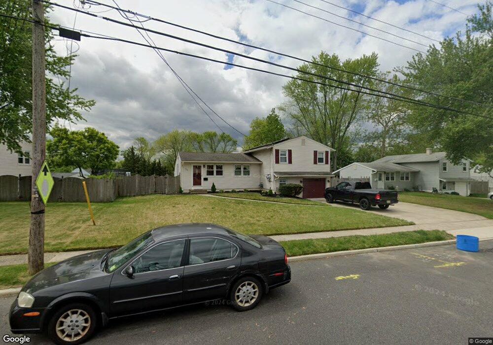
234 Syracuse Ave Wenonah, NJ 08090
Deptford Township NeighborhoodEstimated Value: $284,592 - $386,000
--
Bed
--
Bath
1,510
Sq Ft
$221/Sq Ft
Est. Value
About This Home
This home is located at 234 Syracuse Ave, Wenonah, NJ 08090 and is currently estimated at $333,648, approximately $220 per square foot. 234 Syracuse Ave is a home located in Gloucester County with nearby schools including Deptford Township High School and St Margaret Regional School.
Ownership History
Date
Name
Owned For
Owner Type
Purchase Details
Closed on
Nov 29, 2000
Sold by
Higgins Daniel P and Higgins Teresa A
Bought by
Tighe Bernard J and Tighe Dorothy Ann
Current Estimated Value
Home Financials for this Owner
Home Financials are based on the most recent Mortgage that was taken out on this home.
Original Mortgage
$107,000
Outstanding Balance
$39,601
Interest Rate
7.76%
Estimated Equity
$294,047
Create a Home Valuation Report for This Property
The Home Valuation Report is an in-depth analysis detailing your home's value as well as a comparison with similar homes in the area
Home Values in the Area
Average Home Value in this Area
Purchase History
| Date | Buyer | Sale Price | Title Company |
|---|---|---|---|
| Tighe Bernard J | $125,000 | Freedom Title & Abstract |
Source: Public Records
Mortgage History
| Date | Status | Borrower | Loan Amount |
|---|---|---|---|
| Open | Tighe Bernard J | $107,000 |
Source: Public Records
Tax History Compared to Growth
Tax History
| Year | Tax Paid | Tax Assessment Tax Assessment Total Assessment is a certain percentage of the fair market value that is determined by local assessors to be the total taxable value of land and additions on the property. | Land | Improvement |
|---|---|---|---|---|
| 2025 | $6,578 | $183,500 | $41,700 | $141,800 |
| 2024 | $6,367 | $183,500 | $41,700 | $141,800 |
| 2023 | $6,367 | $183,500 | $41,700 | $141,800 |
| 2022 | $6,322 | $183,500 | $41,700 | $141,800 |
| 2021 | $6,232 | $183,500 | $41,700 | $141,800 |
| 2020 | $6,160 | $183,500 | $41,700 | $141,800 |
| 2019 | $6,043 | $183,500 | $41,700 | $141,800 |
| 2018 | $5,907 | $183,500 | $41,700 | $141,800 |
| 2017 | $5,749 | $183,500 | $41,700 | $141,800 |
| 2016 | $5,632 | $183,500 | $41,700 | $141,800 |
| 2015 | $5,457 | $183,500 | $41,700 | $141,800 |
| 2014 | $5,316 | $183,500 | $41,700 | $141,800 |
Source: Public Records
Map
Nearby Homes
- 100 Buddy Powell Ln
- 7 Manchester Ct
- 114 Buddy Powell Ln
- 313 Ogden Station Rd
- 315 Ogden Station Rd
- 711 Howard Ave
- 916 Georgetown Rd
- 748 Dartmouth Dr
- 125 Ivy Ln
- 111 Cove Rd
- 629 Vassar Rd
- 505 W Mantua Ave
- 213 Barclay Ct
- 8 W Buttonwood St
- 1 W Buttonwood St
- 505 University Blvd
- 807 Saint Regis Ct
- 136 Vanderbilt Ave
- 411 Durham Ct Unit 411
- 463 Durham Ct
- 232 Syracuse Ave
- 236 Syracuse Ave
- 713 Duke Dr
- 230 Syracuse Ave
- 229 Rice Ave
- 238 Syracuse Ave
- 715 Duke Dr
- 233 Syracuse Ave
- 231 Syracuse Ave
- 235 Syracuse Ave
- 227 Rice Ave
- 228 Syracuse Ave
- 229 Syracuse Ave
- 237 Syracuse Ave
- 708 Duke Dr
- 239 Syracuse Ave
- 227 Syracuse Ave
- 225 Rice Ave
- 226 Syracuse Ave
- 710 Duke Dr