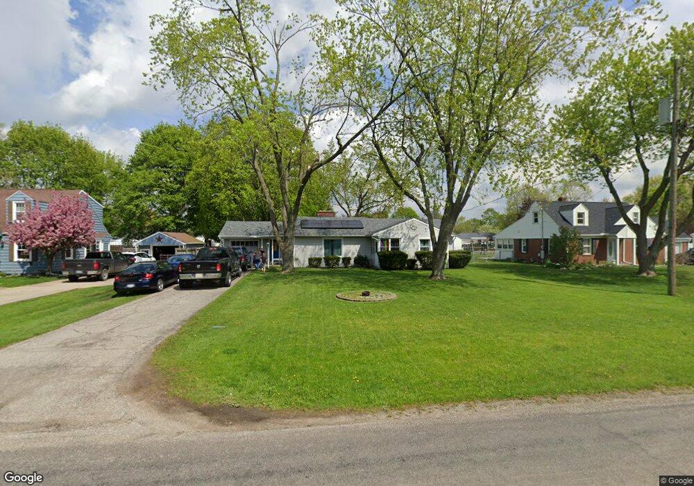
2343 Airport Rd Adrian, MI 49221
Estimated Value: $191,899 - $218,000
3
Beds
2
Baths
1,242
Sq Ft
$167/Sq Ft
Est. Value
About This Home
This home is located at 2343 Airport Rd, Adrian, MI 49221 and is currently estimated at $207,725, approximately $167 per square foot. 2343 Airport Rd is a home located in Lenawee County with nearby schools including Adrian High School, Berean Baptist Academy, and St. Stephen Lutheran School.
Ownership History
Date
Name
Owned For
Owner Type
Purchase Details
Closed on
Jul 1, 2006
Sold by
Gentz Robert E and Gentz Jennie M
Bought by
Francoeur Markus and Francoeur Dawn
Current Estimated Value
Home Financials for this Owner
Home Financials are based on the most recent Mortgage that was taken out on this home.
Original Mortgage
$138,000
Outstanding Balance
$82,244
Interest Rate
6.72%
Mortgage Type
New Conventional
Estimated Equity
$125,481
Create a Home Valuation Report for This Property
The Home Valuation Report is an in-depth analysis detailing your home's value as well as a comparison with similar homes in the area
Home Values in the Area
Average Home Value in this Area
Purchase History
| Date | Buyer | Sale Price | Title Company |
|---|---|---|---|
| Francoeur Markus | $138,000 | Prestige Title Insurance Age |
Source: Public Records
Mortgage History
| Date | Status | Borrower | Loan Amount |
|---|---|---|---|
| Open | Francoeur Markus | $138,000 |
Source: Public Records
Tax History
| Year | Tax Paid | Tax Assessment Tax Assessment Total Assessment is a certain percentage of the fair market value that is determined by local assessors to be the total taxable value of land and additions on the property. | Land | Improvement |
|---|---|---|---|---|
| 2025 | $1,655 | $84,400 | $0 | $0 |
| 2024 | $10 | $76,200 | $0 | $0 |
| 2022 | $866 | $60,000 | $0 | $0 |
| 2021 | $1,506 | $57,700 | $0 | $0 |
| 2020 | $1,505 | $59,000 | $0 | $0 |
| 2019 | $130,247 | $49,700 | $0 | $0 |
| 2018 | $1,459 | $49,658 | $0 | $0 |
| 2017 | $1,407 | $49,226 | $0 | $0 |
| 2016 | $1,648 | $46,422 | $0 | $0 |
| 2014 | -- | $43,105 | $0 | $0 |
Source: Public Records
Map
Nearby Homes
- 2008 Green Acres Dr
- 2010 Green Acres Dr
- 2012 Green Acres Dr
- 2029 Green Acres Dr
- 2018 Green Acres Dr
- 2004 Green Acres Dr
- 2016 Green Acres Dr
- 2026 Green Acres Dr
- 909 Savannah River Dr
- 2673 Airport Rd
- 809 Missouri River Dr
- 1335 Spencer Place
- 521 Rio Grande Dr
- 301 Hidden River Dr
- 1062 Oram Dr
- 217 Red River Dr
- 1637 Rivers Edge Ct
- 1639 Rivers Edge Ct
- 1641 Rivers Edge Ct
- 3520 Crestone Way
- 2347 Airport Rd
- 2346 Airport Rd
- 2359 Airport Rd
- 2319 Airport Rd
- 2336 Airport Rd
- 2375 Airport Rd
- 2338 Sunset Ln
- 2366 Sunset Ln
- 2334 Sunset Ln
- 2374 Sunset Ln
- 2379 Airport Rd
- 2379 Airport Rd
- 2380 Sunset Ln
- 2326 Sunset Ln
- 2327 Sunset Ln
- 2386 Sunset Ln
- 2373 Clearview Ct
- 2390 Sunset Ln
- 2378 Airport Rd
- 2394 Sunset Ln
Your Personal Tour Guide
Ask me questions while you tour the home.