
2345 N Mcaree Rd Waukegan, IL 60087
Bonnie Brook NeighborhoodEstimated payment $2,466/month
Highlights
- Hot Property
- 0.9 Acre Lot
- Mature Trees
- In Ground Pool
- Open Floorplan
- Deck
About This Home
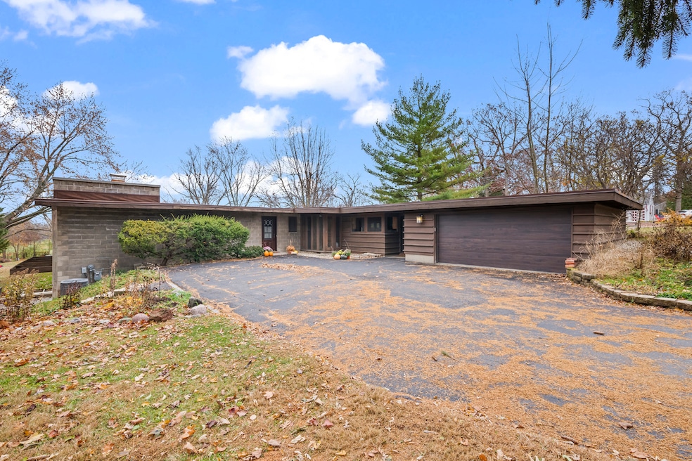
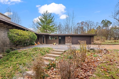
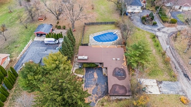
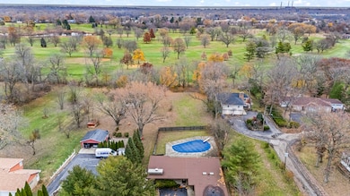
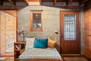
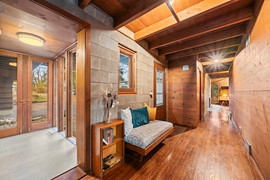
First time on the market! This fantastic 1953 Mid-Century Modern ranch designed by Edward Humrich has been in the same family since it was built! Sitting on a gorgeous lot of almost an acre, and backing to the Bonnie Brook Golf Course, this MCM beauty will delight with it's classic Midwest mid-century features like walls of windows, wood paneled walls, plank & beam ceilings, modular block fireplace and more. Fantastic living room with fireplace and great modernist details will include the 2 sofas and 5 coordinating tables. The home was expanded in the past with the addition of a new two-car garage in the exact same style as the rest of the house, with the former carport enclosed and converted into a large kitchen & dining area that features all stainless appliances as well as heated floors and additional storage. In addition to the three bedrooms (all with hardwood floors) and two bathrooms you'll find a laundry area, large storage closet, a small office and a screened-in porch on the south side of the house. Outside, you'll love the huge lot and the fantastic 40,000 gallon heated pool - 9 feet at the deepest end, and complete with diving board. The lot slopes gently toward the Bonnie Brook Golf Course, and enjoys privacy from numerous mature trees. Partial basement has a 1/2 bath that's also plumbed for a shower, and offers great storage space and access to the outside. Mid-Century Modern homes have increased significantly in value over the past 5 years, so this home represents a fantastic opportunity to get into a modern home designed by a notable architect for a great price and in a beautiful setting! New AC this year. Half bath in basement refreshed in 2025 as well. Two main level baths remodeled in 2021. Furnace replaced in 2017. Washer & Dryer replaced in 2018. Dishwasher replaced in 2020. Modbit roof redone in 2009 with chimney flashing upgraded in 2022. Garage door opener replaced 2025.
Home Details
Home Type
- Single Family
Est. Annual Taxes
- $4,736
Year Built
- Built in 1953
Lot Details
- 0.9 Acre Lot
- Lot Dimensions are 80x487x80x491
- Sloped Lot
- Mature Trees
- Backs to Trees or Woods
Parking
- 2 Car Garage
- Driveway
- Parking Included in Price
Home Design
- Contemporary Architecture
- Block Foundation
- Concrete Perimeter Foundation
Interior Spaces
- 1,852 Sq Ft Home
- 1-Story Property
- Open Floorplan
- Built-In Features
- Beamed Ceilings
- Skylights
- Fireplace With Gas Starter
- Family Room
- Living Room with Fireplace
- Combination Kitchen and Dining Room
- Home Office
Kitchen
- Double Oven
- Cooktop with Range Hood
- Microwave
- Dishwasher
- Stainless Steel Appliances
- Disposal
Flooring
- Wood
- Vinyl
Bedrooms and Bathrooms
- 3 Bedrooms
- 3 Potential Bedrooms
- Bathroom on Main Level
Laundry
- Laundry Room
- Dryer
- Washer
Basement
- Partial Basement
- Finished Basement Bathroom
Outdoor Features
- In Ground Pool
- Deck
Schools
- Oakdale Elementary School
- Jack Benny Middle School
- Waukegan High School
Utilities
- Central Air
- Heating System Uses Natural Gas
- 200+ Amp Service
Community Details
- Bonnie Brook Subdivision, Custom Edward Humrich Floorplan
Listing and Financial Details
- Senior Tax Exemptions
- Homeowner Tax Exemptions
- Senior Freeze Tax Exemptions
Map
Home Values in the Area
Average Home Value in this Area
Tax History
| Year | Tax Paid | Tax Assessment Tax Assessment Total Assessment is a certain percentage of the fair market value that is determined by local assessors to be the total taxable value of land and additions on the property. | Land | Improvement |
|---|---|---|---|---|
| 2024 | $7,139 | $103,902 | $20,572 | $83,330 |
| 2023 | $7,139 | $93,705 | $18,553 | $75,152 |
| 2022 | $7,472 | $76,427 | $27,342 | $49,085 |
| 2021 | $7,898 | $75,760 | $27,103 | $48,657 |
| 2020 | $6,754 | $70,580 | $25,250 | $45,330 |
| 2019 | $8,017 | $70,313 | $23,138 | $47,175 |
| 2018 | $9,131 | $77,007 | $31,569 | $45,438 |
| 2017 | $8,904 | $68,130 | $27,930 | $40,200 |
| 2016 | $7,169 | $52,391 | $21,478 | $30,913 |
| 2015 | $6,907 | $46,891 | $19,223 | $27,668 |
| 2014 | $5,038 | $35,317 | $10,144 | $25,173 |
| 2012 | $5,836 | $38,263 | $10,991 | $27,272 |
Property History
| Date | Event | Price | List to Sale | Price per Sq Ft |
|---|---|---|---|---|
| 12/05/2025 12/05/25 | For Sale | $395,000 | -- | $213 / Sq Ft |
Purchase History
| Date | Type | Sale Price | Title Company |
|---|---|---|---|
| Interfamily Deed Transfer | -- | Fidelity National Title | |
| Deed | -- | -- |
Mortgage History
| Date | Status | Loan Amount | Loan Type |
|---|---|---|---|
| Open | $60,000 | New Conventional |
Source: Midwest Real Estate Data (MRED)
MLS Number: 12519961
APN: 08-08-101-017
Disclaimer: Certain information contained herein is derived from information provided by parties other than Homes.com. All information provided is deemed reliable, but is not guaranteed to be accurate and should be independently verified.
![]() Based on information submitted to the MLS GRID. All data is obtained from various sources and may not have been verified by broker or MLS GRID. Supplied Open House Information is subject to change without notice. All information should be independently reviewed and verified for accuracy. Properties may or may not be listed by the office/agent presenting the information. Some IDX listings have been excluded from this website.
Based on information submitted to the MLS GRID. All data is obtained from various sources and may not have been verified by broker or MLS GRID. Supplied Open House Information is subject to change without notice. All information should be independently reviewed and verified for accuracy. Properties may or may not be listed by the office/agent presenting the information. Some IDX listings have been excluded from this website.
The Digital Millennium Copyright Act of 1998, 17 U.S.C. § 512 (the “DMCA”) provides recourse for copyright owners who believe that material appearing on the Internet infringes their rights under U.S. copyright law. If you believe in good faith that any content or material made available in connection with our website or services infringes your copyright, you (or your agent) may send us a notice requesting that the content or material be removed, or access to it blocked.
Notices must be sent in writing by email to DMCAnotice@MLSGrid.com.
The DMCA requires that your notice of alleged copyright infringement include the following information:
(1) description of the copyrighted work that is the subject of claimed infringement;
(2) description of the alleged infringing content and information sufficient to permit us to locate the content;
(3) contact information for you, including your address, telephone number and email address;
(4) a statement by you that you have a good faith belief that the content in the manner complained of is not authorized by the copyright owner, or its agent, or by the operation of any law;
(5) a statement by you, signed under penalty of perjury, that the information in the notification is accurate and that you have the authority to enforce the copyrights that are claimed to be infringed; and
(6) a physical or electronic signature of the copyright owner or a person authorized to act on the copyright owner’s behalf. Failure to include all of the above information may result in the delay of the processing of your complaint.
- 2705 Dana Ave
- 2713 Varonen Ave
- 2708 Dana Ave
- 2350 N Lewis Ave
- 12312 W Audrey Ave
- 2613 N Lewis Ave
- 2440 W Cheyenne Rd
- 3032 W Vermont Ave
- 3320 Sunset Ave
- 2928 W Country Club Ave
- 3000 W Country Club Ave
- 2946 W Country Club Ave
- 36955 N Garrick Ave
- 2715 W Greenwood Ave
- 2207 Williamsburg Dr
- 1612 Whitney St
- 3101 Country Club Ln
- 36245 N Green Bay Rd
- 2810 W Atlantic Ave
- 1636 Rice St
- 2330 N Samson Way
- 2101 Lorraine Ave Unit 8
- 1610 Sunset Ave
- 2035-2045 Georgetown Ln
- 3305 Sunset Ave Unit 129
- 3305 Sunset Ave Unit 126
- 2020 Linden Ave
- 2532 N Jackson St Unit ID1265538P
- 2701 W Glen Flora Ave
- 2805 W Glen Flora Ave
- 915 W Pacific Ave Unit ID1265537P
- 2801-2813 Grandville Ct
- 1335 N Jackson St Unit ID1265536P
- 931 W Glen Flora Ave Unit ID1265541P
- 1317 N Jackson St Unit ID1265539P
- 37936 N Wilson Ave
- 1947 W Eagle Ridge Dr
- 1532 North Ave Unit ID1265540P
- 805 Baldwin Ave
- 1428 North Ave Unit ID1309882P
