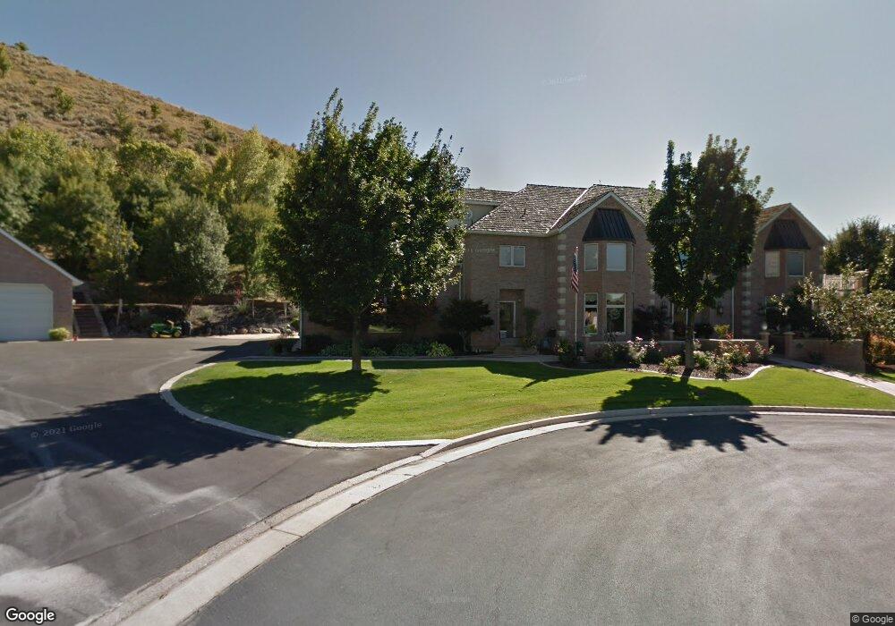
235 Blake Ct Logan, UT 84321
Wilson NeighborhoodEstimated Value: $1,464,000 - $1,845,000
7
Beds
5
Baths
11,575
Sq Ft
$146/Sq Ft
Est. Value
About This Home
This home is located at 235 Blake Ct, Logan, UT 84321 and is currently estimated at $1,688,504, approximately $145 per square foot. 235 Blake Ct is a home located in Cache County with nearby schools including Wilson School, Mount Logan Middle School, and Logan High School.
Ownership History
Date
Name
Owned For
Owner Type
Purchase Details
Closed on
Feb 6, 2025
Sold by
Luman David P
Bought by
David P Luman Family Revocable Trust and Suzanne Luman Family Revocable Trust
Current Estimated Value
Home Financials for this Owner
Home Financials are based on the most recent Mortgage that was taken out on this home.
Original Mortgage
$100,000
Outstanding Balance
$99,223
Interest Rate
6.85%
Mortgage Type
Credit Line Revolving
Estimated Equity
$1,589,281
Purchase Details
Closed on
Dec 19, 2023
Sold by
Luman David P
Bought by
Suzanne Luman Family Revocable Trust and David P Luman Family Revocable Trust
Home Financials for this Owner
Home Financials are based on the most recent Mortgage that was taken out on this home.
Original Mortgage
$2,766,898
Interest Rate
7.5%
Mortgage Type
New Conventional
Purchase Details
Closed on
Jun 12, 2020
Sold by
Luman David P and Luman Suzanne
Bought by
Luman David P and The David P Luman Family Revoc
Home Financials for this Owner
Home Financials are based on the most recent Mortgage that was taken out on this home.
Original Mortgage
$510,400
Interest Rate
3.2%
Mortgage Type
New Conventional
Purchase Details
Closed on
Jun 24, 2014
Sold by
Luman David P and Luman Suzanne
Bought by
Luman David P and David P Luman Family Revocable Trust
Purchase Details
Closed on
Nov 26, 2001
Sold by
Luman David P and Luman Brenda S
Bought by
Luman David P and Luman Suzanne
Purchase Details
Closed on
Aug 30, 2001
Sold by
Luman David P
Bought by
Luman David P and Luman Brenda S
Home Financials for this Owner
Home Financials are based on the most recent Mortgage that was taken out on this home.
Original Mortgage
$550,000
Interest Rate
7.09%
Purchase Details
Closed on
Aug 23, 2001
Sold by
Luman Brenda S
Bought by
Luman David P
Home Financials for this Owner
Home Financials are based on the most recent Mortgage that was taken out on this home.
Original Mortgage
$550,000
Interest Rate
7.09%
Create a Home Valuation Report for This Property
The Home Valuation Report is an in-depth analysis detailing your home's value as well as a comparison with similar homes in the area
Home Values in the Area
Average Home Value in this Area
Purchase History
| Date | Buyer | Sale Price | Title Company |
|---|---|---|---|
| David P Luman Family Revocable Trust | -- | Northern Title | |
| David P Luman Family Revocable Trust | -- | Northern Title | |
| Luman David P | -- | Northern Title | |
| Luman David P | -- | Northern Title | |
| Suzanne Luman Family Revocable Trust | -- | Northern Title Company | |
| Luman David P | -- | Northern Title Company | |
| Luman David P | -- | Northern Title Company | |
| Luman David P | -- | Northern Title Company | |
| Luman David P | -- | None Available | |
| Luman David P | -- | Northern Title Company | |
| Luman David P | -- | Northern Title Company | |
| Luman David P | -- | Northern Title Company |
Source: Public Records
Mortgage History
| Date | Status | Borrower | Loan Amount |
|---|---|---|---|
| Open | Luman David P | $100,000 | |
| Closed | Luman David P | $100,000 | |
| Previous Owner | Luman David P | $2,766,898 | |
| Previous Owner | Luman David P | $510,400 | |
| Previous Owner | Luman David P | $550,000 |
Source: Public Records
Tax History
| Year | Tax Paid | Tax Assessment Tax Assessment Total Assessment is a certain percentage of the fair market value that is determined by local assessors to be the total taxable value of land and additions on the property. | Land | Improvement |
|---|---|---|---|---|
| 2025 | $7,790 | $1,007,470 | $0 | $0 |
| 2024 | $8,043 | $1,007,470 | $0 | $0 |
| 2023 | $7,782 | $929,230 | $0 | $0 |
| 2022 | $8,334 | $929,230 | $0 | $0 |
| 2021 | $7,873 | $1,328,300 | $209,800 | $1,118,500 |
| 2020 | $8,719 | $1,323,958 | $209,800 | $1,114,158 |
| 2019 | $9,114 | $1,323,958 | $209,800 | $1,114,158 |
| 2018 | $9,666 | $1,281,106 | $209,800 | $1,071,306 |
| 2017 | $9,893 | $708,355 | $0 | $0 |
| 2016 | $10,257 | $665,325 | $0 | $0 |
| 2015 | $7,731 | $533,305 | $0 | $0 |
| 2014 | $6,988 | $533,305 | $0 | $0 |
| 2013 | -- | $533,305 | $0 | $0 |
Source: Public Records
Map
Nearby Homes
- 1535 Sumac Dr
- 1387 E 260 N
- 147 Winding Way Unit 50
- 1374 E 260 N
- 1647 E Quail Canyon Dr
- 1374 Maple Dr
- 825 N 1400 E
- 128 S 1170 E
- 866 Hillcrest Ave
- 1045 Fox Farm Rd
- 1034 Thrushwood Dr
- 1147 Eastridge Dr
- 74 Canterbury Cir
- 1133 N 1520 E
- 1164 E Mountain Rd
- 28 River Pointe Dr
- 2758 N Canyon Cove Dr
- 2738 N Canyon Cove Dr
- 70 River Pointe Dr
- 1782 E 1250 N
- 244 Blake Ct
- 247 Blake Ct
- 1598 Quail Way
- 268 N 1570 E
- 1645 E Quail Way
- 268 N Haddie Cir Unit 6
- 1678 E Quail Way
- 1584 E Quail Way
- 1621 E Quail Way
- 273 N 1570 E
- 1615 Quail Way
- 1562 Quail Way
- 261 N 1570 E
- 1581 Quail Way
- 1709 E Quail Way
- 1548 Quail Way
- 1557 Quail Way
- 1538 Quail Way
- 1543 Quail Way
- 1714 E Quail Way
Your Personal Tour Guide
Ask me questions while you tour the home.