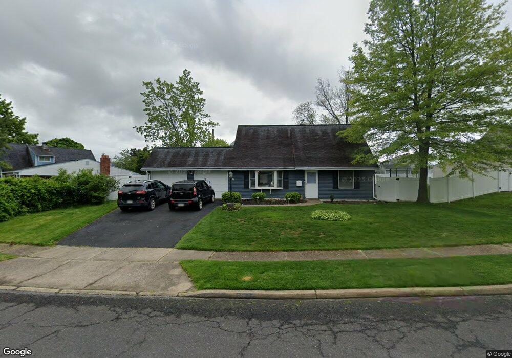
235 Cobalt Ridge Dr S Levittown, PA 19057
Estimated Value: $394,775 - $447,000
3
Beds
2
Baths
1,419
Sq Ft
$295/Sq Ft
Est. Value
About This Home
This home is located at 235 Cobalt Ridge Dr S, Levittown, PA 19057 and is currently estimated at $419,194, approximately $295 per square foot. 235 Cobalt Ridge Dr S is a home located in Bucks County with nearby schools including Walter Miller Elementary School, Sandburg Middle School, and Neshaminy High School.
Ownership History
Date
Name
Owned For
Owner Type
Purchase Details
Closed on
Jun 13, 2019
Sold by
Estate Of Carolyn R Zimmerman
Bought by
Bresch Paul M and Valenzuela Desirae Nichole
Current Estimated Value
Home Financials for this Owner
Home Financials are based on the most recent Mortgage that was taken out on this home.
Original Mortgage
$200,000
Outstanding Balance
$175,849
Interest Rate
4.1%
Mortgage Type
New Conventional
Estimated Equity
$243,345
Purchase Details
Closed on
Jul 5, 1962
Bought by
Zimmerman James D
Create a Home Valuation Report for This Property
The Home Valuation Report is an in-depth analysis detailing your home's value as well as a comparison with similar homes in the area
Home Values in the Area
Average Home Value in this Area
Purchase History
| Date | Buyer | Sale Price | Title Company |
|---|---|---|---|
| Bresch Paul M | $250,000 | Members Settlement Svcs Llc | |
| Zimmerman James D | -- | -- |
Source: Public Records
Mortgage History
| Date | Status | Borrower | Loan Amount |
|---|---|---|---|
| Open | Bresch Paul M | $200,000 |
Source: Public Records
Tax History Compared to Growth
Tax History
| Year | Tax Paid | Tax Assessment Tax Assessment Total Assessment is a certain percentage of the fair market value that is determined by local assessors to be the total taxable value of land and additions on the property. | Land | Improvement |
|---|---|---|---|---|
| 2025 | $4,618 | $21,210 | $3,840 | $17,370 |
| 2024 | $4,618 | $21,210 | $3,840 | $17,370 |
| 2023 | $4,544 | $21,210 | $3,840 | $17,370 |
| 2022 | $4,425 | $21,210 | $3,840 | $17,370 |
| 2021 | $4,425 | $21,210 | $3,840 | $17,370 |
| 2020 | $4,372 | $21,210 | $3,840 | $17,370 |
| 2019 | $4,274 | $21,210 | $3,840 | $17,370 |
| 2018 | $4,196 | $21,210 | $3,840 | $17,370 |
| 2017 | $4,089 | $21,210 | $3,840 | $17,370 |
| 2016 | $4,089 | $21,210 | $3,840 | $17,370 |
| 2015 | $4,278 | $21,210 | $3,840 | $17,370 |
| 2014 | $4,278 | $21,210 | $3,840 | $17,370 |
Source: Public Records
Map
Nearby Homes
- 14 Cleft Rock Rd
- 23 Crystal Place
- 33 Red Rose Way
- 7 Canal Rd
- 19 Cobalt Ridge Dr N
- 17 Quay Rd
- 14 Cinnamon Rd
- 26 Queen Lily Rd
- 58 Queen Lily Rd
- 154 Juniper Dr
- 35 Inland Rd
- 75 Flamehill Rd
- 114 Nursery Ave
- 94 Juniper Dr
- 46 Quill Rd
- 57 Island Rd
- 331 Indian Creek Dr
- 479 Stanford Rd
- 31 Quail Rd
- 88 Forsythia Dr N
- 239 Cobalt Ridge Dr S
- 83 Canyon Rd
- 79 Canyon Rd
- 72 Canoebirch Rd
- 77 Canyon Rd
- 236 Cobalt Ridge Dr S
- 2 Cleft Rock Rd
- 70 Canoebirch Rd
- 242 Cobalt Ridge Dr S
- 223 Cobalt Ridge Dr S
- 2 Candle Rd
- 73 Canyon Rd
- 78 Canyon Rd
- 73 Canoebirch Rd
- 246 Cobalt Ridge Dr S
- 68 Canoebirch Rd
- 5 Candle Rd
- 8 Cleft Rock Rd
- 74 Canyon Rd
- 224 Cobalt Ridge Dr S