Estimated Value: $38,000 - $77,000
Studio
--
Bath
784
Sq Ft
$74/Sq Ft
Est. Value
About This Home
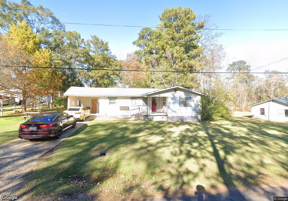
This home is located at 235 Daniel St, Many, LA 71449 and is currently estimated at $58,036, approximately $74 per square foot. 235 Daniel St is a home located in Sabine Parish with nearby schools including Many Junior High School and Many High School.
Ownership History
Date
Name
Owned For
Owner Type
Purchase Details
Closed on
Apr 5, 2018
Sold by
Collier Ruiby D
Bought by
Bulls Eye Properties Llc
Current Estimated Value
Home Financials for this Owner
Home Financials are based on the most recent Mortgage that was taken out on this home.
Original Mortgage
$38,012
Interest Rate
4.46%
Mortgage Type
Purchase Money Mortgage
Purchase Details
Closed on
Nov 14, 2005
Sold by
Pickett John S and Pickett Joanna H
Bought by
Collier Jimmie Lee and Collier Ruby D
Create a Home Valuation Report for This Property
The Home Valuation Report is an in-depth analysis detailing your home's value as well as a comparison with similar homes in the area
Home Values in the Area
Average Home Value in this Area
Purchase History
| Date | Buyer | Sale Price | Title Company |
|---|---|---|---|
| Bulls Eye Properties Llc | $45,000 | -- | |
| Collier Jimmie Lee | $3,425 | None Available |
Source: Public Records
Mortgage History
| Date | Status | Borrower | Loan Amount |
|---|---|---|---|
| Closed | Bulls Eye Properties Llc | $38,012 |
Source: Public Records
Tax History
| Year | Tax Paid | Tax Assessment Tax Assessment Total Assessment is a certain percentage of the fair market value that is determined by local assessors to be the total taxable value of land and additions on the property. | Land | Improvement |
|---|---|---|---|---|
| 2025 | $296 | $3,246 | $230 | $3,016 |
| 2024 | $266 | $3,246 | $230 | $3,016 |
| 2023 | $260 | $3,210 | $345 | $2,865 |
| 2022 | $286 | $3,210 | $345 | $2,865 |
| 2021 | $306 | $3,210 | $345 | $2,865 |
| 2020 | $331 | $3,210 | $345 | $2,865 |
| 2019 | $322 | $3,210 | $345 | $2,865 |
| 2018 | $181 | $1,720 | $240 | $1,480 |
| 2017 | $181 | $1,720 | $240 | $1,480 |
| 2016 | $180 | $1,720 | $240 | $1,480 |
| 2015 | $167 | $1,720 | $240 | $1,480 |
| 2014 | -- | $1,720 | $240 | $1,480 |
Source: Public Records
Map
Nearby Homes
- 295 Highland Ave
- 120 Fisher Rd
- 000TBD Highway 171
- 25500 Highway 171
- 000 Hwy 171 S
- 910 Ponder St Unit 27
- 1113 Alieze St
- 0 Chasin Fin Dr Unit 6
- 0 Chasin Fin Dr Unit 5
- 0 Chasin Fin Dr Unit 4
- 0 Commercial Park Dr Unit 10931381
- 00 Chasin Fin Dr Unit 2
- 0 **Mobile Home Only** Unit TO BE MOVED!!!!
- 0 Chasin Fin Dr Unit 7
- 00 Chasin Fin Dr Unit 3
- 765 N Capitol St
- 295 Pine St
- 825 Shreveport Hwy
- 825 Shreveport Hwy Unit 8 & 9 Blk 14
- 850 Hill St
- 225 Daniel St
- 220 Caledonia St
- 245 Daniel St
- 230 Daniel St
- 210 Caledonia St
- 215 Daniel St
- 220 Daniel St
- 200 Caledonia St
- 200 Caledonia St
- 221 Caledonia St
- 145 Lawrence Ave
- 245 Caledonia St
- 213 Lawrence Ave
- 215 Caledonia St
- 210 Daniel St
- 215 Lawrence Ave
- 135 Lawrence Ave
- 205 Daniel St
- 295 Lawrence Ave
- 255 Caledonia St
Your Personal Tour Guide
Ask me questions while you tour the home.