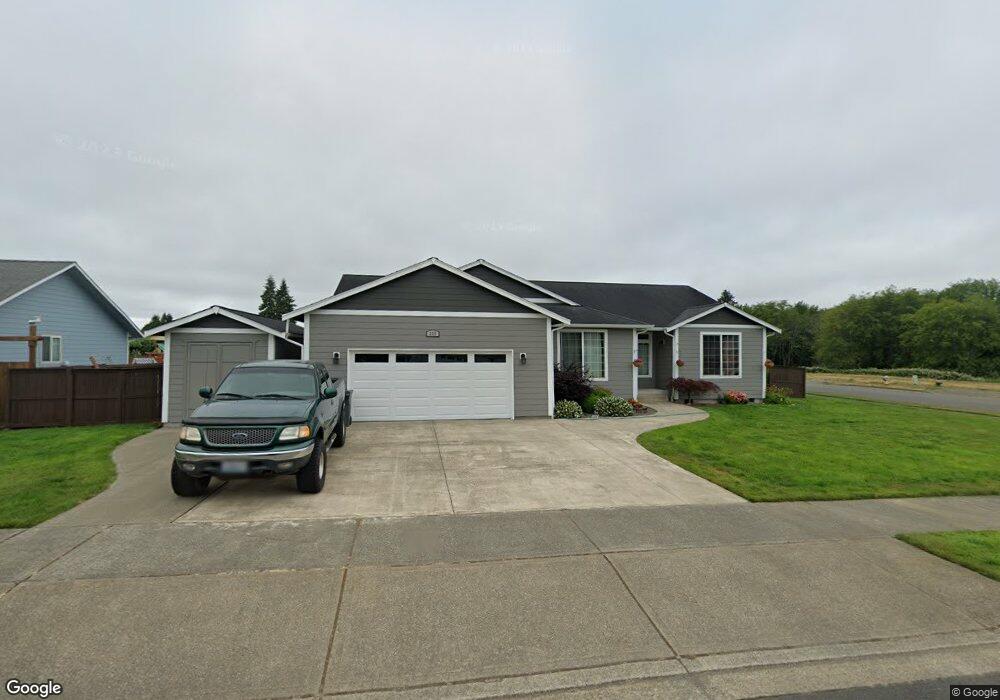
235 Maple St Montesano, WA 98563
Estimated Value: $465,969 - $555,000
3
Beds
2
Baths
2,264
Sq Ft
$219/Sq Ft
Est. Value
About This Home
This home is located at 235 Maple St, Montesano, WA 98563 and is currently estimated at $495,242, approximately $218 per square foot. 235 Maple St is a home located in Grays Harbor County with nearby schools including Beacon Avenue Elementary School, Simpson Avenue Elementary School, and Montesano Junior/Senior High School.
Ownership History
Date
Name
Owned For
Owner Type
Purchase Details
Closed on
Jun 9, 2010
Sold by
First Citizens Bank & Trust Company
Bought by
Roberts Angela M and Roberts Shannon L
Current Estimated Value
Home Financials for this Owner
Home Financials are based on the most recent Mortgage that was taken out on this home.
Original Mortgage
$168,700
Outstanding Balance
$115,145
Interest Rate
5.03%
Mortgage Type
New Conventional
Estimated Equity
$380,097
Purchase Details
Closed on
Mar 17, 2010
Sold by
The Federal Deposit Insurance Corporatio
Bought by
First Citizens Bank & Trust Company
Create a Home Valuation Report for This Property
The Home Valuation Report is an in-depth analysis detailing your home's value as well as a comparison with similar homes in the area
Home Values in the Area
Average Home Value in this Area
Purchase History
| Date | Buyer | Sale Price | Title Company |
|---|---|---|---|
| Roberts Angela M | $39,000 | Grays Harbor Title | |
| First Citizens Bank & Trust Company | -- | Accommodation |
Source: Public Records
Mortgage History
| Date | Status | Borrower | Loan Amount |
|---|---|---|---|
| Open | Roberts Angela M | $168,700 |
Source: Public Records
Tax History
| Year | Tax Paid | Tax Assessment Tax Assessment Total Assessment is a certain percentage of the fair market value that is determined by local assessors to be the total taxable value of land and additions on the property. | Land | Improvement |
|---|---|---|---|---|
| 2025 | $4,078 | $441,140 | $85,000 | $356,140 |
| 2023 | $4,126 | $468,616 | $56,600 | $412,016 |
| 2022 | $3,941 | $364,170 | $51,440 | $312,730 |
| 2021 | $3,653 | $364,170 | $51,440 | $312,730 |
| 2020 | $3,820 | $307,037 | $45,920 | $261,117 |
| 2019 | $3,137 | $309,645 | $54,000 | $255,645 |
| 2018 | $3,805 | $276,948 | $40,000 | $236,948 |
| 2017 | $3,403 | $263,617 | $35,000 | $228,617 |
| 2016 | $3,105 | $252,730 | $35,000 | $217,730 |
| 2014 | -- | $234,245 | $22,000 | $212,245 |
| 2013 | -- | $234,320 | $22,000 | $212,320 |
Source: Public Records
Map
Nearby Homes
- 100 Meadow Loop
- 214 N Talbot St
- 1008 E Pioneer Ave
- 102 S Chehalis St
- 126 S Chehalis St
- 23 Garden Tracts Rd
- 603 Church St N
- 303 E Broadway Ave
- 312 E Wilder Hill Ln
- 318 W Marcy Ave
- 404 W Marcy Ave
- 517 W Broadway Ave
- 209 Monte Elma Rd
- 213 Monte Elma Rd
- 527 S 5th St
- 542 S 6th St
- 15 Miller Ln
- 816 W Simpson Ave
- 733 Washington 107
- 0 Off of Washington 107
Your Personal Tour Guide
Ask me questions while you tour the home.