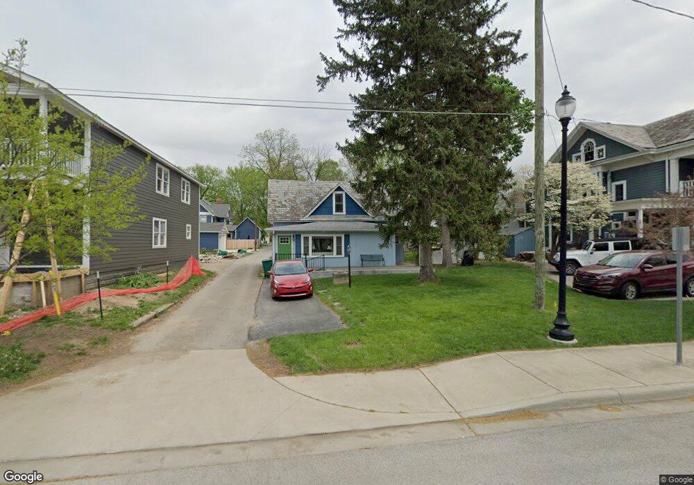
235 N Main St Franklin, IN 46131
Estimated Value: $173,000 - $245,000
3
Beds
2
Baths
1,584
Sq Ft
$134/Sq Ft
Est. Value
About This Home
This home is located at 235 N Main St, Franklin, IN 46131 and is currently estimated at $212,691, approximately $134 per square foot. 235 N Main St is a home located in Johnson County with nearby schools including Northwood Elementary School, Franklin Community Middle School, and Custer Baker Intermediate School.
Ownership History
Date
Name
Owned For
Owner Type
Purchase Details
Closed on
Oct 27, 2025
Sold by
Jean Martin Keystone Trust and Balding Kerry
Bought by
Jean Martin Keystone Trust
Current Estimated Value
Purchase Details
Closed on
Jun 8, 2018
Sold by
Martin Jean
Bought by
Keystone Trust
Purchase Details
Closed on
Jun 18, 2007
Sold by
Martin John E
Bought by
Martin Jean
Purchase Details
Closed on
Jul 26, 2006
Sold by
Wilson David A
Bought by
Wilson David A and Wilson Peggy A
Purchase Details
Closed on
Jul 14, 2006
Sold by
First Bank Richmond Na
Bought by
Patton David
Create a Home Valuation Report for This Property
The Home Valuation Report is an in-depth analysis detailing your home's value as well as a comparison with similar homes in the area
Home Values in the Area
Average Home Value in this Area
Purchase History
| Date | Buyer | Sale Price | Title Company |
|---|---|---|---|
| Jean Martin Keystone Trust | -- | Denali Title | |
| Richardson Robert | -- | Denali Title | |
| Keystone Trust | -- | None Available | |
| Martin Jean | -- | None Available | |
| Wilson David A | -- | None Available | |
| Wilson David A | -- | None Available | |
| Patton David | -- | None Available |
Source: Public Records
Tax History Compared to Growth
Tax History
| Year | Tax Paid | Tax Assessment Tax Assessment Total Assessment is a certain percentage of the fair market value that is determined by local assessors to be the total taxable value of land and additions on the property. | Land | Improvement |
|---|---|---|---|---|
| 2025 | $248 | $152,100 | $11,400 | $140,700 |
| 2024 | $248 | $121,400 | $11,600 | $109,800 |
| 2023 | $243 | $115,600 | $11,600 | $104,000 |
| 2022 | $238 | $104,800 | $10,500 | $94,300 |
| 2021 | $234 | $96,700 | $10,200 | $86,500 |
| 2020 | $229 | $99,600 | $10,200 | $89,400 |
| 2019 | $225 | $92,000 | $8,700 | $83,300 |
| 2018 | $379 | $79,700 | $8,700 | $71,000 |
| 2017 | $524 | $79,000 | $8,700 | $70,300 |
| 2016 | $653 | $69,900 | $8,700 | $61,200 |
| 2014 | $520 | $78,600 | $15,300 | $63,300 |
| 2013 | $520 | $72,500 | $15,300 | $57,200 |
Source: Public Records
Map
Nearby Homes
- 298 N Water St
- 0 W 900 Hwy Unit 202537998
- 147 E King St
- 199 Walnut St
- 178 S Water St Unit F
- 76 E Wayne St Unit B
- 348 Ohio St
- 252 S Main St
- 751 Graham St
- 698 Yandes St
- 351 Cincinnati St
- 750 Hurricane St
- 651 Hamilton Ave
- 998 E King St
- 1110 Hillview Dr
- 123 14th St
- 1121 E Adams Dr
- 772 Franklin Lakes Blvd
- 21 S Dawn Dr
- 1624 Roberts Rd