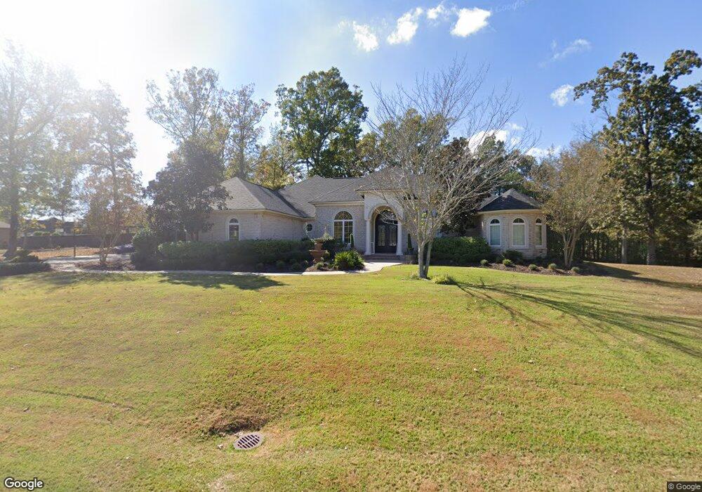
235 Saint Andrews Rd Calhoun, LA 71225
Estimated Value: $591,000 - $641,000
3
Beds
5
Baths
4,274
Sq Ft
$146/Sq Ft
Est. Value
About This Home
This home is located at 235 Saint Andrews Rd, Calhoun, LA 71225 and is currently estimated at $625,028, approximately $146 per square foot. 235 Saint Andrews Rd is a home located in Ouachita Parish with nearby schools including Calhoun Elementary School, Central Elementary School, and Calhoun Middle School.
Ownership History
Date
Name
Owned For
Owner Type
Purchase Details
Closed on
Apr 30, 2025
Sold by
Tillman Percy Anthony and Tillman Claudia Hicks
Bought by
Falcon Donald and Falcon Roberta
Current Estimated Value
Home Financials for this Owner
Home Financials are based on the most recent Mortgage that was taken out on this home.
Original Mortgage
$500,000
Outstanding Balance
$499,563
Interest Rate
6.67%
Mortgage Type
New Conventional
Estimated Equity
$125,465
Purchase Details
Closed on
Mar 4, 2013
Sold by
Hardie Matthew James and Hardie Shannon Dawn Anding
Bought by
Steffins Daniel Frederick and Steffins Andrea Michelle O Neal
Home Financials for this Owner
Home Financials are based on the most recent Mortgage that was taken out on this home.
Original Mortgage
$417,000
Interest Rate
3.43%
Mortgage Type
New Conventional
Purchase Details
Closed on
Aug 21, 2008
Sold by
Forbes Christian Patrick and Forbes Nicole Bruno
Bought by
Hardie Mathew James and Hardie Shannon Dawn Anding
Home Financials for this Owner
Home Financials are based on the most recent Mortgage that was taken out on this home.
Original Mortgage
$50,000
Interest Rate
6.52%
Mortgage Type
Credit Line Revolving
Purchase Details
Closed on
May 19, 2006
Sold by
Frantom Timothy Kirk and Frantom Misty West
Bought by
Forbes Christian P and Forbes Nicole B
Home Financials for this Owner
Home Financials are based on the most recent Mortgage that was taken out on this home.
Original Mortgage
$50,000
Interest Rate
6.6%
Mortgage Type
Credit Line Revolving
Purchase Details
Closed on
Mar 2, 2005
Sold by
Drew Partnership
Bought by
Frantom Timothy Kirk and West Frantom Misty Dawn
Home Financials for this Owner
Home Financials are based on the most recent Mortgage that was taken out on this home.
Original Mortgage
$150,000
Interest Rate
5.78%
Mortgage Type
Unknown
Create a Home Valuation Report for This Property
The Home Valuation Report is an in-depth analysis detailing your home's value as well as a comparison with similar homes in the area
Home Values in the Area
Average Home Value in this Area
Purchase History
| Date | Buyer | Sale Price | Title Company |
|---|---|---|---|
| Falcon Donald | $630,000 | None Listed On Document | |
| Steffins Daniel Frederick | $490,000 | North Delta Title | |
| Hardie Mathew James | $462,000 | None Available | |
| Forbes Christian P | $422,500 | Title West | |
| Frantom Timothy Kirk | $47,000 | None Available |
Source: Public Records
Mortgage History
| Date | Status | Borrower | Loan Amount |
|---|---|---|---|
| Open | Falcon Donald | $500,000 | |
| Previous Owner | Steffins Daniel Frederick | $472,000 | |
| Previous Owner | Steffins Daniel | $423,900 | |
| Previous Owner | Steffins Daniel Frederick | $49,500 | |
| Previous Owner | Steffins Daniel Frederick | $417,000 | |
| Previous Owner | Hardie Matthew James | $369,600 | |
| Previous Owner | Hardie Matthew James | $50,000 | |
| Previous Owner | Hardie Mathew James | $369,600 | |
| Previous Owner | Forbes Christian P | $50,000 | |
| Previous Owner | Forbes Christian P | $330,000 | |
| Previous Owner | Frntom Timothy Kirk | $168,500 | |
| Previous Owner | Frantom Timothy Kirk | $150,000 |
Source: Public Records
Tax History Compared to Growth
Tax History
| Year | Tax Paid | Tax Assessment Tax Assessment Total Assessment is a certain percentage of the fair market value that is determined by local assessors to be the total taxable value of land and additions on the property. | Land | Improvement |
|---|---|---|---|---|
| 2024 | $4,354 | $55,045 | $4,950 | $50,095 |
| 2023 | $4,354 | $45,260 | $4,950 | $40,310 |
| 2022 | $4,015 | $45,260 | $4,950 | $40,310 |
| 2021 | $4,065 | $45,260 | $4,950 | $40,310 |
| 2020 | $4,065 | $45,260 | $4,950 | $40,310 |
| 2019 | $4,021 | $44,897 | $4,950 | $39,947 |
| 2018 | $3,349 | $44,897 | $4,950 | $39,947 |
| 2017 | $3,902 | $43,570 | $4,950 | $38,620 |
| 2016 | $4,019 | $46,200 | $7,392 | $38,808 |
| 2015 | $3,457 | $46,200 | $7,392 | $38,808 |
| 2014 | $3,457 | $46,200 | $7,392 | $38,808 |
| 2013 | $3,445 | $46,200 | $7,392 | $38,808 |
Source: Public Records
Map
Nearby Homes
- 257 Sugarloaf Dr
- 0 Laguna Villas Dr
- 138 Mangum Ln
- 3235 Highway 15
- 0 (A) Carter Rd
- 0 (B) Carter Rd
- 000 C Carter Rd
- 3375 Highway 15
- 111 Yellow Pine Dr
- 131 Yellow Pine Dr
- 201 Glen Acres Rd
- 000 J T Griggs Rd Unit 454 J T Griggs Road
- 00 J T Griggs Rd Unit 454 J T Griggs Road
- 454 J T Griggs Rd
- 0 J T Griggs Rd Unit 454 J T Griggs Road
- 301 Pine Hills Dr
- 1014 Highway 80 E
- 430 Pine Hills Dr
- 159 Chapel Ln
- 137 Patricks Cove
- 233 Saint Andrews Rd
- 233 Saint Andrews Rd
- 238 Saint Andrews Dr
- 240 Saint Andrews Rd
- 242 Saint Andrews Dr
- 234 Saint Andrews Dr
- 242 Saint Andrews Rd
- 231 Saint Andrews Rd
- 232 Saint Andrews Rd
- 232 Saint Andrews Dr
- 230 Saint Andrews Rd
- 230 Saint Andrews Rd
- 226 Saint Andrews Rd
- 228 Saint Andrews Dr
- 1570 Brownlee Rd
- 226 Saint Andrews Dr
- 257 Sugarloaf Ln
- 1594 Brownlee Rd
- 103 Glen Eagles Rd
- 103 Glen Eagles Ct