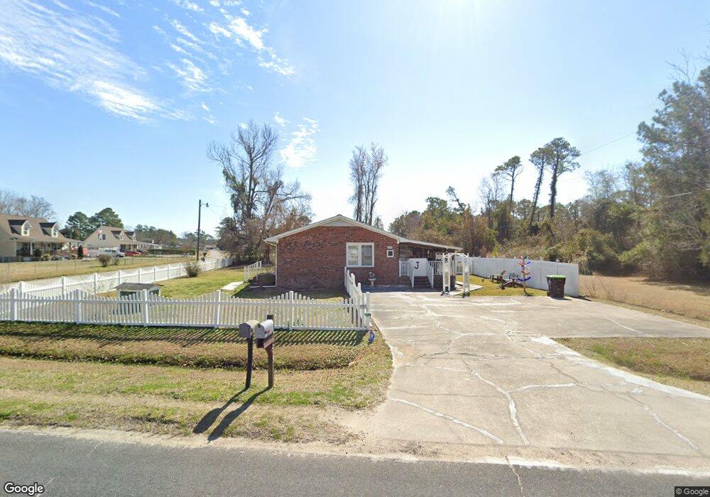
235 Tom Mann Rd Newport, NC 28570
Estimated Value: $181,210 - $242,000
3
Beds
1
Bath
960
Sq Ft
$217/Sq Ft
Est. Value
About This Home
This home is located at 235 Tom Mann Rd, Newport, NC 28570 and is currently estimated at $208,303, approximately $216 per square foot. 235 Tom Mann Rd is a home located in Carteret County with nearby schools including Newport Elementary School, Newport Middle School, and West Carteret High School.
Ownership History
Date
Name
Owned For
Owner Type
Purchase Details
Closed on
Feb 28, 2017
Sold by
Langlais Laurent and Jones Mary Ellon
Bought by
Jones Mary Ellen
Current Estimated Value
Purchase Details
Closed on
Feb 22, 2017
Sold by
Jones Mary Ellen
Bought by
Jones Mary Ellen and The Mary Ellen Jones Revocable
Purchase Details
Closed on
Jun 5, 2015
Sold by
Jones Mary Ellen and Jones Mary Ellen Langlais
Bought by
Jones Ernest L and Jones Mary Ellen
Create a Home Valuation Report for This Property
The Home Valuation Report is an in-depth analysis detailing your home's value as well as a comparison with similar homes in the area
Home Values in the Area
Average Home Value in this Area
Purchase History
| Date | Buyer | Sale Price | Title Company |
|---|---|---|---|
| Jones Mary Ellen | -- | None Available | |
| Jones Mary Ellen | -- | None Available | |
| Langlais Laurent | -- | None Available | |
| Jones Mary Ellen | -- | None Available | |
| Jones Ernest L | -- | None Available | |
| Bogdahn Michael | -- | Attorney |
Source: Public Records
Tax History Compared to Growth
Tax History
| Year | Tax Paid | Tax Assessment Tax Assessment Total Assessment is a certain percentage of the fair market value that is determined by local assessors to be the total taxable value of land and additions on the property. | Land | Improvement |
|---|---|---|---|---|
| 2025 | $411 | $189,941 | $58,048 | $131,893 |
| 2024 | $268 | $70,858 | $34,475 | $36,383 |
| 2023 | $335 | $70,858 | $34,475 | $36,383 |
| 2022 | $331 | $70,858 | $34,475 | $36,383 |
| 2021 | $0 | $70,858 | $34,475 | $36,383 |
| 2020 | $332 | $70,858 | $34,475 | $36,383 |
| 2019 | $177 | $81,141 | $39,400 | $41,741 |
| 2017 | $323 | $81,141 | $39,400 | $41,741 |
| 2016 | $488 | $81,141 | $39,400 | $41,741 |
| 2015 | $480 | $81,141 | $39,400 | $41,741 |
| 2014 | -- | $84,833 | $35,090 | $49,743 |
Source: Public Records
Map
Nearby Homes
- 764 Chatham St
- 757 Chatham St
- 223 Independence Blvd
- 251 Independence Blvd
- 258 Independence Blvd
- 554 Chatham St
- 114 Duncan Ln
- 113 Duncan Ln
- 2211 Park Ave
- 730 Chatham St
- Tyler Plan at Heritage Pointe - Carolina Series
- Bayhill Plan at Heritage Pointe - Carolina Series
- Ryan Plan at Heritage Pointe - Carolina Series
- Thornwood Plan at Heritage Pointe - Carolina Series
- Pamlico Plan at Heritage Pointe - Carolina Series
- Westin Plan at Heritage Pointe - Carolina Series
- Birmingham Plan at Heritage Pointe - Carolina Series
- Corbin Plan at Heritage Pointe - Carolina Series
- Molly Plan at Heritage Pointe - Carolina Series
- Mason Plan at Heritage Pointe - Carolina Series
- 245 Tom Mann Rd
- 185 Woodland Dr
- 217 Tom Mann Rd
- 236 Tom Mann Rd
- 218 Tom Mann Rd
- 182 Sherwood Rd
- 179 Woodland Dr
- 242 Tom Mann Rd
- 259 Tom Mann Rd
- 174 Sherwood Rd
- 161 Woodland Dr
- 251 Tom Mann Rd
- 250 Tom Mann Rd
- 165 Sherwood Dr
- 153 Woodland Dr
- 157 Sherwood Rd
- 145 Woodland Dr
- 152 Sherwood Dr
- 185 Tom Mann Rd
- 152 Sherwood Rd