Estimated Value: $605,188 - $680,000
3
Beds
4
Baths
2,074
Sq Ft
$310/Sq Ft
Est. Value
About This Home
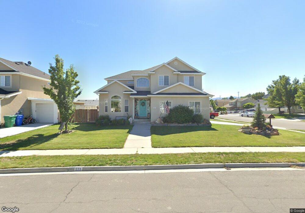
This home is located at 235 W 1640 N, Lehi, UT 84043 and is currently estimated at $642,547, approximately $309 per square foot. 235 W 1640 N is a home located in Utah County with nearby schools including Sego Lily Elementary School, Lehi Junior High School, and Skyridge High School.
Ownership History
Date
Name
Owned For
Owner Type
Purchase Details
Closed on
Apr 30, 2004
Sold by
Salisbury Development Lc
Bought by
Atwood Jeff and Atwood Barbara
Current Estimated Value
Home Financials for this Owner
Home Financials are based on the most recent Mortgage that was taken out on this home.
Original Mortgage
$166,500
Outstanding Balance
$77,240
Interest Rate
5.35%
Mortgage Type
Purchase Money Mortgage
Estimated Equity
$565,307
Create a Home Valuation Report for This Property
The Home Valuation Report is an in-depth analysis detailing your home's value as well as a comparison with similar homes in the area
Home Values in the Area
Average Home Value in this Area
Purchase History
| Date | Buyer | Sale Price | Title Company |
|---|---|---|---|
| Atwood Jeff | -- | Provo Land Title Co |
Source: Public Records
Mortgage History
| Date | Status | Borrower | Loan Amount |
|---|---|---|---|
| Open | Atwood Jeff | $166,500 |
Source: Public Records
Tax History Compared to Growth
Tax History
| Year | Tax Paid | Tax Assessment Tax Assessment Total Assessment is a certain percentage of the fair market value that is determined by local assessors to be the total taxable value of land and additions on the property. | Land | Improvement |
|---|---|---|---|---|
| 2025 | $2,460 | $313,775 | $205,100 | $365,400 |
| 2024 | $2,460 | $287,870 | $0 | $0 |
| 2023 | $2,324 | $295,240 | $0 | $0 |
| 2022 | $2,537 | $312,565 | $0 | $0 |
| 2021 | $2,293 | $427,100 | $118,700 | $308,400 |
| 2020 | $2,163 | $398,100 | $109,900 | $288,200 |
| 2019 | $1,979 | $378,800 | $109,900 | $268,900 |
| 2018 | $1,874 | $339,100 | $96,100 | $243,000 |
| 2017 | $1,832 | $176,165 | $0 | $0 |
| 2016 | $1,868 | $166,705 | $0 | $0 |
| 2015 | $1,879 | $159,170 | $0 | $0 |
| 2014 | $1,688 | $142,175 | $0 | $0 |
Source: Public Records
Map
Nearby Homes
- 1755 N 250 W
- 4333 N Baiken Ridge Dr Unit 1020
- 1329 N 100 E Unit 21
- 1150 N 200 W Unit 6
- 1295 N 190 E
- 497 W 2200 N
- 1817 W Bad Rock Cir
- 996 N 200 W
- 595 W 2200 N
- 902 W 1500 N
- 155 W State St Unit TRLR 3
- 68 W State St
- 497 W 2280 N
- 1301 N 900 W Unit 12
- 192 E 2200 N
- 1011 W Mountain Way Unit 316
- 7 E State St
- 1610 N 1125 W
- 443 W 820 N
- 1094 W 1425 N