Estimated Value: $156,171 - $382,000
3
Beds
3
Baths
1,850
Sq Ft
$161/Sq Ft
Est. Value
About This Home
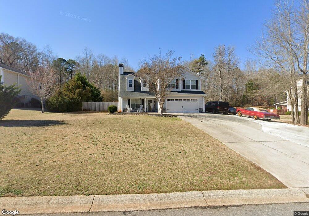
This home is located at 235 Watson Dr, Hull, GA 30646 and is currently estimated at $298,043, approximately $161 per square foot. 235 Watson Dr is a home with nearby schools including Madison County High School.
Ownership History
Date
Name
Owned For
Owner Type
Purchase Details
Closed on
Sep 19, 2025
Sold by
Haynes Brookes
Bought by
Haynes Mequikaan D
Current Estimated Value
Home Financials for this Owner
Home Financials are based on the most recent Mortgage that was taken out on this home.
Original Mortgage
$155,000
Outstanding Balance
$154,862
Interest Rate
6.58%
Mortgage Type
New Conventional
Estimated Equity
$143,181
Purchase Details
Closed on
Aug 1, 2011
Sold by
Landstar Construction Inc
Bought by
Haynes Brookes
Home Financials for this Owner
Home Financials are based on the most recent Mortgage that was taken out on this home.
Original Mortgage
$149,200
Interest Rate
4.53%
Mortgage Type
Purchase Money Mortgage
Purchase Details
Closed on
Nov 29, 2010
Sold by
Southern Pride Land & Development Llc
Bought by
Landstar Construction Inc
Create a Home Valuation Report for This Property
The Home Valuation Report is an in-depth analysis detailing your home's value as well as a comparison with similar homes in the area
Purchase History
| Date | Buyer | Sale Price | Title Company |
|---|---|---|---|
| Haynes Mequikaan D | $155,000 | -- | |
| Haynes Brookes | $149,200 | -- | |
| Landstar Construction Inc | $20,000 | -- |
Source: Public Records
Mortgage History
| Date | Status | Borrower | Loan Amount |
|---|---|---|---|
| Open | Haynes Mequikaan D | $155,000 | |
| Previous Owner | Haynes Brookes | $149,200 |
Source: Public Records
Tax History
| Year | Tax Paid | Tax Assessment Tax Assessment Total Assessment is a certain percentage of the fair market value that is determined by local assessors to be the total taxable value of land and additions on the property. | Land | Improvement |
|---|---|---|---|---|
| 2025 | $2,812 | $112,656 | $12,000 | $100,656 |
| 2024 | $2,207 | $86,784 | $9,600 | $77,184 |
| 2023 | $2,498 | $81,830 | $9,600 | $72,230 |
| 2022 | $1,954 | $72,845 | $9,600 | $63,245 |
| 2021 | $1,684 | $57,175 | $9,600 | $47,575 |
| 2020 | $1,696 | $57,175 | $9,600 | $47,575 |
| 2019 | $1,685 | $56,174 | $9,600 | $46,574 |
| 2018 | $1,640 | $54,597 | $9,600 | $44,997 |
| 2017 | $1,663 | $57,746 | $12,000 | $45,746 |
| 2016 | $1,539 | $55,602 | $12,000 | $43,602 |
| 2015 | $1,513 | $54,696 | $8,800 | $45,896 |
| 2014 | $1,526 | $54,815 | $8,800 | $46,015 |
| 2013 | -- | $54,815 | $8,800 | $46,015 |
Source: Public Records
Map
Nearby Homes
- 210 Joe Graham Rd
- 103 Three Rivers Ct
- 151 Rolling Woods Ln
- 149 Candlestick Dr
- 0 Spratlin Mill Dr Unit 7665837
- 0 Spratlin Mill Dr Unit LOT 14-C
- 450 Candlestick Dr
- 1618 McCannon Morris Rd
- 65 Kimberly Way
- 1330 McCannon-morris Rd
- 1151 Kimberly Cir
- 975 Diamond Hill Neese Rd
- 1176 Kimberly Cir
- 140 Kimberly Way
- 1067 Garnett Ward Rd Unit 2
- 73 Woodale St
- 142 Rolling Woods Ln Unit 29
- 142 Rolling Woods Ln
- 768 Glenn Carrie Rd
- 1360 Glenn Carrie Rd
- 217 Watson Dr
- 12 Watson Dr
- 259 Watson Dr
- Lot 10 Watson Dr
- Lot 20 Watson Dr
- Lot 24 Watson Dr
- Lot 23 Watson Dr
- 279 Watson Dr
- 260 Watson Dr
- 185 Watson Dr
- 289 Watson Dr
- 210 Watson Dr Unit 9
- 236 Watson Dr
- 159 Watson Dr
- 280 Watson Dr Unit 14
- 280 Watson Dr
- 319 Watson Dr
- 300 Watson Dr Unit 15
- 150 Watson Dr
- 135 Watson Dr Unit 33
Your Personal Tour Guide
Ask me questions while you tour the home.