Estimated Value: $206,000 - $245,000
4
Beds
2
Baths
1,637
Sq Ft
$137/Sq Ft
Est. Value
About This Home
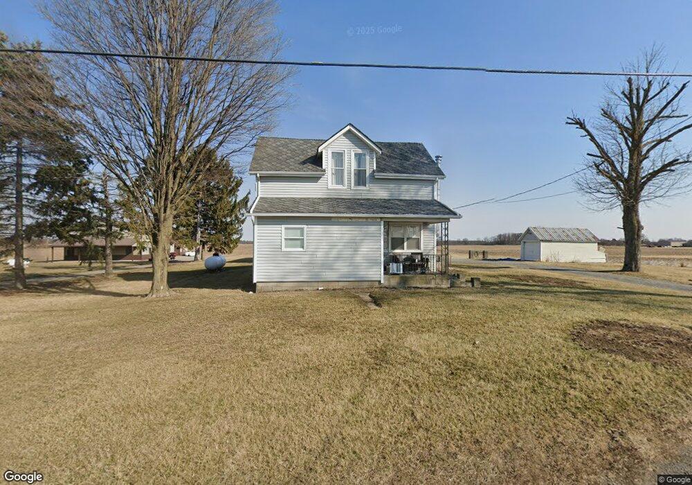
This home is located at 2353 State Route 81, Ada, OH 45810 and is currently estimated at $225,059, approximately $137 per square foot. 2353 State Route 81 is a home located in Hardin County with nearby schools including Ada Elementary School and Ada High School.
Ownership History
Date
Name
Owned For
Owner Type
Purchase Details
Closed on
Jan 27, 2014
Sold by
Bates Steven D and Schulman Jeffrey M
Bought by
Wyndham Enterprises Ltd
Current Estimated Value
Purchase Details
Closed on
May 7, 2011
Sold by
Cupples Joyce E and Gillaspie Jeana E
Bought by
Bates Steven D and Schulman Jeffrey M
Home Financials for this Owner
Home Financials are based on the most recent Mortgage that was taken out on this home.
Original Mortgage
$67,500
Interest Rate
4.88%
Mortgage Type
New Conventional
Purchase Details
Closed on
Mar 30, 2011
Sold by
Cupples Joyce E and Fox Joyce E
Bought by
Cupples Joyce E and Gillaspie Jeana
Home Financials for this Owner
Home Financials are based on the most recent Mortgage that was taken out on this home.
Original Mortgage
$67,500
Interest Rate
4.88%
Mortgage Type
New Conventional
Purchase Details
Closed on
Jun 3, 2004
Bought by
Fox Joyce E
Create a Home Valuation Report for This Property
The Home Valuation Report is an in-depth analysis detailing your home's value as well as a comparison with similar homes in the area
Purchase History
| Date | Buyer | Sale Price | Title Company |
|---|---|---|---|
| Wyndham Enterprises Ltd | -- | None Available | |
| Bates Steven D | $90,000 | None Available | |
| Cupples Joyce E | -- | None Available | |
| Fox Joyce E | -- | -- |
Source: Public Records
Mortgage History
| Date | Status | Borrower | Loan Amount |
|---|---|---|---|
| Previous Owner | Bates Steven D | $67,500 |
Source: Public Records
Tax History
| Year | Tax Paid | Tax Assessment Tax Assessment Total Assessment is a certain percentage of the fair market value that is determined by local assessors to be the total taxable value of land and additions on the property. | Land | Improvement |
|---|---|---|---|---|
| 2024 | $1,971 | $51,710 | $11,060 | $40,650 |
| 2023 | $1,957 | $51,710 | $11,060 | $40,650 |
| 2022 | $1,558 | $35,710 | $5,800 | $29,910 |
| 2021 | $1,718 | $35,710 | $5,800 | $29,910 |
| 2020 | $1,742 | $35,710 | $5,800 | $29,910 |
| 2019 | $1,572 | $32,610 | $5,590 | $27,020 |
| 2018 | $1,537 | $32,610 | $5,590 | $27,020 |
| 2017 | $1,331 | $32,610 | $5,590 | $27,020 |
| 2016 | $1,163 | $26,570 | $5,060 | $21,510 |
| 2015 | $1,137 | $26,570 | $5,060 | $21,510 |
| 2014 | $4,492 | $26,570 | $5,060 | $21,510 |
| 2013 | $1,843 | $26,710 | $5,060 | $21,650 |
Source: Public Records
Map
Nearby Homes
- 602 Conley Ave
- 327 W North Ave
- 128 W North Ave
- 629 N Main St
- 724 N Main St
- 210 N Gilbert St
- 211 S Main St
- 746 N Main St Unit 61
- 746 N Main St Unit 63
- 746 N Main St Unit 74
- 746 N Main St Unit 9
- 746 N Main St Unit 35
- 746 N Main St Unit 5
- 746 N Main St Unit 39
- 442 Edwards St
- 503 E North Ave
- 308-310 S Simon St
- 314 E University Ave
- 710 S Main St
- 820 S Main St
- 2353 Ohio 81
- 2353 St Route
- 2319 State Route 81
- 2421 St Route
- 2421 State Route 81
- 2237 State Route 81
- 2230 State Route 81
- 2219 State Route 81
- 609 W North Ave
- 2191 State Route 81
- 605 W North Ave
- 2172 State Route 81
- 2172 Ohio 81
- 2172 Ohio 81
- 601 W North Ave
- 2163 State Route 81
- 2134 State Route 81
- 530 Merri Monte Ln
Your Personal Tour Guide
Ask me questions while you tour the home.