Estimated Value: $289,000 - $316,000
3
Beds
2
Baths
2,009
Sq Ft
$150/Sq Ft
Est. Value
About This Home
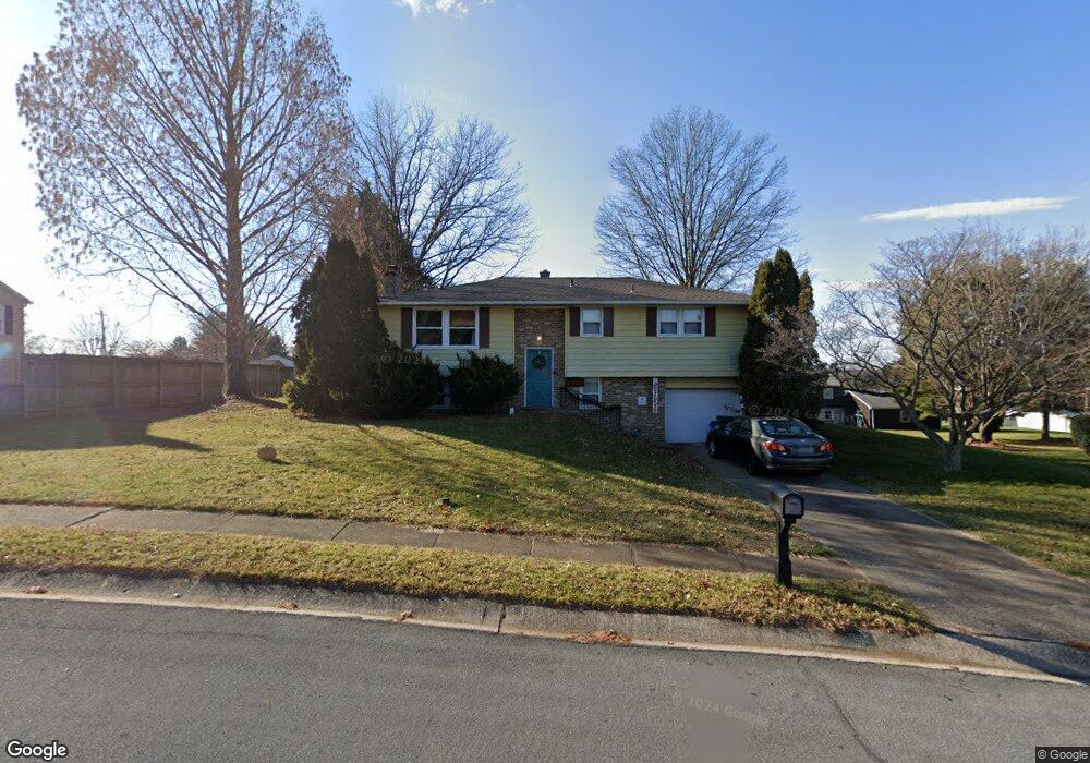
This home is located at 2355 Esbenshade Rd, York, PA 17408 and is currently estimated at $302,239, approximately $150 per square foot. 2355 Esbenshade Rd is a home located in York County with nearby schools including West York Area High School, York Adventist Christian School, and Christian School of York.
Ownership History
Date
Name
Owned For
Owner Type
Purchase Details
Closed on
Aug 6, 2013
Sold by
Allmond Virgil L and Allmond Sandi W
Bought by
Allmond Sandi W
Current Estimated Value
Purchase Details
Closed on
Apr 23, 2010
Sold by
Firestone Leon C
Bought by
Allmond Virgil K and Allmond Sandi W
Home Financials for this Owner
Home Financials are based on the most recent Mortgage that was taken out on this home.
Original Mortgage
$154,156
Outstanding Balance
$105,183
Interest Rate
5.5%
Mortgage Type
FHA
Estimated Equity
$197,056
Purchase Details
Closed on
Feb 11, 2009
Sold by
Firestone Leon C and Firestone Betty J
Bought by
Firestone Leon C
Create a Home Valuation Report for This Property
The Home Valuation Report is an in-depth analysis detailing your home's value as well as a comparison with similar homes in the area
Home Values in the Area
Average Home Value in this Area
Purchase History
| Date | Buyer | Sale Price | Title Company |
|---|---|---|---|
| Allmond Sandi W | -- | None Available | |
| Allmond Virgil K | $157,000 | None Available | |
| Firestone Leon C | -- | None Available |
Source: Public Records
Mortgage History
| Date | Status | Borrower | Loan Amount |
|---|---|---|---|
| Open | Allmond Virgil K | $154,156 |
Source: Public Records
Tax History Compared to Growth
Tax History
| Year | Tax Paid | Tax Assessment Tax Assessment Total Assessment is a certain percentage of the fair market value that is determined by local assessors to be the total taxable value of land and additions on the property. | Land | Improvement |
|---|---|---|---|---|
| 2025 | $4,258 | $126,270 | $34,270 | $92,000 |
| 2024 | $4,151 | $126,270 | $34,270 | $92,000 |
| 2023 | $4,151 | $126,270 | $34,270 | $92,000 |
| 2022 | $4,151 | $126,270 | $34,270 | $92,000 |
| 2021 | $4,025 | $126,270 | $34,270 | $92,000 |
| 2020 | $4,025 | $126,270 | $34,270 | $92,000 |
| 2019 | $3,949 | $126,270 | $34,270 | $92,000 |
| 2018 | $3,917 | $126,270 | $34,270 | $92,000 |
| 2017 | $3,797 | $126,270 | $34,270 | $92,000 |
| 2016 | $0 | $126,270 | $34,270 | $92,000 |
| 2015 | -- | $126,270 | $34,270 | $92,000 |
| 2014 | -- | $126,270 | $34,270 | $92,000 |
Source: Public Records
Map
Nearby Homes
- 2351 Birch Rd
- 2285 Sycamore Rd
- 2700 Thornbridge Rd E
- 2451 Log Cabin Rd
- 2709 Sunset Ln
- 2263 Manor Rd
- 2090 Sycamore Rd
- 2790 Butternut Ln
- 2461 Heather Rd
- 2132 Log Cabin Rd
- 2417 Berkshire Ln
- 2636 Sedgewick Ave
- 2450 Walnut Bottom Rd Unit 85
- 2481 Broad St
- 2800 Hialeah Ct
- 1769 Rainbow Cir
- 2270 Seneca Dr
- 2633 Grandview Park Dr Unit 39
- 2644 Grandview Park Dr Unit 5
- 3121 Pineview Dr
- 2365 Esbenshade Rd
- 0 Manor Rd
- 2183 Derry Rd
- 2345 Esbenshade Rd
- 2187 Derry Rd
- 2179 Derry Rd
- 2350 Esbenshade Rd
- 2360 Esbenshade Rd
- 2335 Esbenshade Rd
- 2191 Derry Rd
- 2557 Esbenshade Rd
- 2560 Manor Rd
- 2173 Derry Rd
- 2325 Esbenshade Rd
- 2172 Croyden Rd
- 2310 Esbenshade Rd
- 2158 Derry Rd
- 2175 Twinbrook Dr
- 2168 Croyden Rd
- 2553 Manor Rd