Estimated Value: $219,000 - $327,605
4
Beds
1
Bath
1,792
Sq Ft
$156/Sq Ft
Est. Value
About This Home
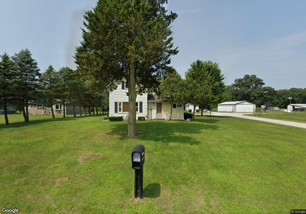
This home is located at 2355 S 700 E, Knox, IN 46534 and is currently estimated at $279,868, approximately $156 per square foot. 2355 S 700 E is a home located in Starke County with nearby schools including Knox Community Elementary School, Knox Community Middle School, and Knox Community High School.
Ownership History
Date
Name
Owned For
Owner Type
Purchase Details
Closed on
Dec 13, 2022
Sold by
Degard Donald K and Degard Sandra K
Bought by
Degard Donald K and Vancuren Kathy L
Current Estimated Value
Purchase Details
Closed on
Nov 14, 2022
Sold by
Degard Donald K
Bought by
Degard Dollard K and Degard Sandra K
Purchase Details
Closed on
Nov 8, 2022
Sold by
Vancuren Kathy L
Bought by
Degard Donald K and Degard Sandra K
Purchase Details
Closed on
Jan 26, 2022
Sold by
Degard Sr Donald K and Degard Sandra
Bought by
Degard Kevin A
Purchase Details
Closed on
Sep 18, 2018
Sold by
Degard Donald K and Degard Sandra K
Bought by
Degard Donald K and Degard Michelle L
Create a Home Valuation Report for This Property
The Home Valuation Report is an in-depth analysis detailing your home's value as well as a comparison with similar homes in the area
Home Values in the Area
Average Home Value in this Area
Purchase History
| Date | Buyer | Sale Price | Title Company |
|---|---|---|---|
| Degard Donald K | -- | -- | |
| Degard David | -- | -- | |
| Degard Dollard K | -- | -- | |
| Degard Donald K | -- | -- | |
| Degard Kevin A | -- | None Listed On Document | |
| Degard Donald K | -- | None Available |
Source: Public Records
Tax History Compared to Growth
Tax History
| Year | Tax Paid | Tax Assessment Tax Assessment Total Assessment is a certain percentage of the fair market value that is determined by local assessors to be the total taxable value of land and additions on the property. | Land | Improvement |
|---|---|---|---|---|
| 2024 | $1,319 | $198,100 | $46,200 | $151,900 |
| 2023 | $1,576 | $187,300 | $48,400 | $138,900 |
| 2022 | $1,576 | $169,100 | $41,200 | $127,900 |
| 2021 | $1,499 | $147,200 | $37,800 | $109,400 |
| 2020 | $1,622 | $141,000 | $37,600 | $103,400 |
| 2019 | $1,548 | $138,100 | $42,200 | $95,900 |
| 2018 | $1,559 | $138,700 | $44,700 | $94,000 |
| 2017 | $1,617 | $140,400 | $49,100 | $91,300 |
| 2016 | $1,647 | $140,400 | $51,100 | $89,300 |
| 2014 | $1,307 | $129,800 | $51,700 | $78,100 |
| 2013 | $1,186 | $124,100 | $46,600 | $77,500 |
Source: Public Records
Map
Nearby Homes
- 6830 Homette Ave
- TBD F Wild Rose Dr
- TBD G Wild Rose Dr
- TBD D Wild Rose Dr
- TBD H Wild Rose Dr
- TBD C Wild Rose Dr
- TBD E Wild Rose Dr
- TBD I Wild Rose Dr
- 6978 Fox Crossing
- TBD Fox Crossing
- 0 Fox Crossing Unit NRA822621
- - Fox Crossing
- 3455 S 800 E
- 0-Rear Toto Rd
- 3701 S 625 E
- 3835 S Hillcrest Rd
- 8692 E 200 S
- 3872 S Hillcrest Rd
- 9.08 Acres S North Dr & East of Woodland Rd E
- 6270 E Donald Rd