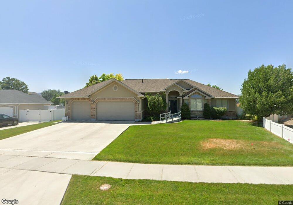
2357 W 11625 S South Jordan, UT 84095
Estimated Value: $779,000 - $960,000
3
Beds
3
Baths
2,207
Sq Ft
$405/Sq Ft
Est. Value
About This Home
This home is located at 2357 W 11625 S, South Jordan, UT 84095 and is currently estimated at $894,106, approximately $405 per square foot. 2357 W 11625 S is a home located in Salt Lake County with nearby schools including Monte Vista Elementary School, South Jordan Middle School, and Hawthorn Academy South Jordan.
Ownership History
Date
Name
Owned For
Owner Type
Purchase Details
Closed on
Nov 19, 2021
Sold by
Carol M Stocking Family Trust and Stocking Lisa Irene
Bought by
Lisa Irene Stocking Trust and Karen Stocking Trust
Current Estimated Value
Purchase Details
Closed on
Sep 20, 2021
Sold by
Carol M Stocking Amended Family Trust
Bought by
Carol M Stocking Family Trust
Purchase Details
Closed on
Mar 24, 2007
Sold by
Jack Fredrick R and Jack Barbara H
Bought by
Stocking Carol M and Carol M Stocking Amended Family Trust
Purchase Details
Closed on
Apr 25, 2001
Sold by
Ann Am Construction Inc
Bought by
Jack Fredrick R and Jack Barbara H
Home Financials for this Owner
Home Financials are based on the most recent Mortgage that was taken out on this home.
Original Mortgage
$259,100
Interest Rate
6.98%
Create a Home Valuation Report for This Property
The Home Valuation Report is an in-depth analysis detailing your home's value as well as a comparison with similar homes in the area
Home Values in the Area
Average Home Value in this Area
Purchase History
| Date | Buyer | Sale Price | Title Company |
|---|---|---|---|
| Lisa Irene Stocking Trust | -- | None Listed On Document | |
| Carol M Stocking Family Trust | -- | Hunt Joshua F | |
| Stocking Carol M | -- | Surety Title | |
| Jack Fredrick R | -- | Backman Stewart Title Servic |
Source: Public Records
Mortgage History
| Date | Status | Borrower | Loan Amount |
|---|---|---|---|
| Previous Owner | Jack Fredrick R | $259,100 |
Source: Public Records
Tax History Compared to Growth
Tax History
| Year | Tax Paid | Tax Assessment Tax Assessment Total Assessment is a certain percentage of the fair market value that is determined by local assessors to be the total taxable value of land and additions on the property. | Land | Improvement |
|---|---|---|---|---|
| 2025 | $4,394 | $828,800 | $303,100 | $525,700 |
| 2024 | $4,394 | $760,500 | $288,600 | $471,900 |
| 2023 | $4,389 | $716,100 | $280,200 | $435,900 |
| 2022 | $4,516 | $722,800 | $274,700 | $448,100 |
| 2021 | $3,708 | $528,500 | $227,100 | $301,400 |
| 2020 | $3,656 | $485,800 | $227,100 | $258,700 |
| 2019 | $3,626 | $473,700 | $214,900 | $258,800 |
| 2018 | $0 | $445,300 | $213,700 | $231,600 |
| 2017 | $3,406 | $426,900 | $210,000 | $216,900 |
| 2016 | $3,453 | $415,300 | $194,100 | $221,200 |
| 2015 | $3,478 | $405,500 | $196,000 | $209,500 |
| 2014 | -- | $491,500 | $186,800 | $304,700 |
Source: Public Records
Map
Nearby Homes
- 11707 S Myers Park Ln Unit 111
- 11788 S Myers Park Ln Unit 101
- 2511 W 11730 S
- 2295 W Myers Ln
- 2602 W 11625 S
- 2626 W Midas Side Way
- 11716 S 2610 W
- 11513 S Jackson Downs Way
- 2410 W 11400 S
- 11666 S Gold Dust Dr
- 2732 W Lizzi Cove
- 2817 W 11460 St S Unit 203
- 11423 S Polo Club Ct
- 1767 W Lunford Ln
- 12034 S 1900 W
- 1721 W Hollow Cedar Ln Unit 1
- 2853 W 12075 S
- 1592 W Andover Rd
- 1611 W Laurel Chase Dr
- 3028 W Wilkins Peak Ct
- 2337 W 11625 S
- 2393 W 11625 S
- 2372 W 11625 S
- 2326 W 11625 S
- 11609 S Chapel Rim Way
- 11609 Chapel Rim Way
- 2297 W 11625 S
- 2419 W 11625 S
- 2361 Charter Pointe Rd
- 2383 Charter Pointe Rd
- 2383 W Charter Pointe Rd
- 2296 W 11625 S
- 2298 W 11625 S
- 2414 W Midas Side Way
- 11697 S Midas Side Way
- 11597 S Chapel Rim Way
- 2403 Charter Pointe Rd
- 11577 S Charter Pointe Rd
- 11577 Charter Pointe Rd
- 2437 W 11625 S