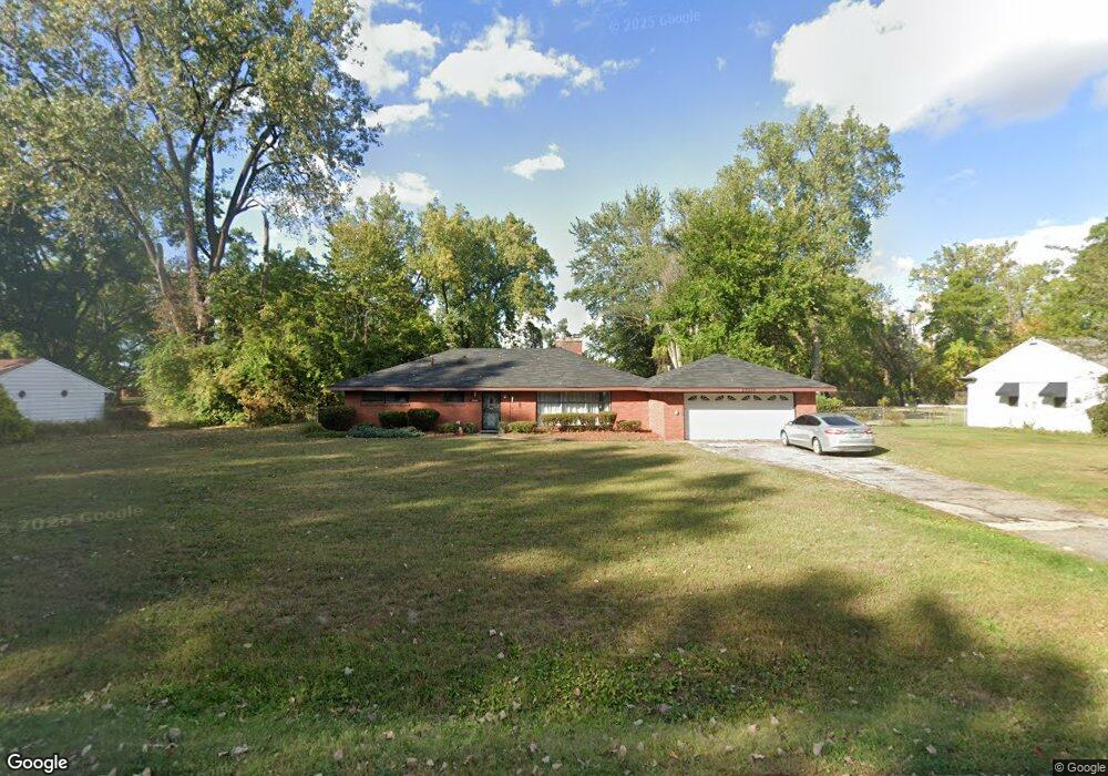
23634 Philip Dr Southfield, MI 48075
Estimated Value: $248,030 - $273,000
3
Beds
2
Baths
1,586
Sq Ft
$163/Sq Ft
Est. Value
About This Home
This home is located at 23634 Philip Dr, Southfield, MI 48075 and is currently estimated at $258,258, approximately $162 per square foot. 23634 Philip Dr is a home located in Oakland County with nearby schools including Morris Adler Elementary School, Glenn W. Levey Middle School, and Oak Park Service Learning Academy.
Ownership History
Date
Name
Owned For
Owner Type
Purchase Details
Closed on
Apr 16, 2010
Sold by
Secretary Of Housing & Urban Development
Bought by
Daniels Monica
Current Estimated Value
Purchase Details
Closed on
Dec 2, 2008
Sold by
National City Real Estate Services Llc
Bought by
The Secretary Of Housing & Urban Develop
Purchase Details
Closed on
Jul 22, 2008
Sold by
Forbes Kevin
Bought by
National City Real Estate Services Llc
Purchase Details
Closed on
Sep 13, 1999
Sold by
Webster Frances Marie
Bought by
Forbes Kevin
Create a Home Valuation Report for This Property
The Home Valuation Report is an in-depth analysis detailing your home's value as well as a comparison with similar homes in the area
Home Values in the Area
Average Home Value in this Area
Purchase History
| Date | Buyer | Sale Price | Title Company |
|---|---|---|---|
| Daniels Monica | $44,000 | Capital Title Ins Agency | |
| The Secretary Of Housing & Urban Develop | -- | None Available | |
| National City Real Estate Services Llc | $136,240 | None Available | |
| Forbes Kevin | $125,000 | -- |
Source: Public Records
Tax History Compared to Growth
Tax History
| Year | Tax Paid | Tax Assessment Tax Assessment Total Assessment is a certain percentage of the fair market value that is determined by local assessors to be the total taxable value of land and additions on the property. | Land | Improvement |
|---|---|---|---|---|
| 2022 | $2,522 | $82,890 | $19,910 | $62,980 |
| 2021 | $2,566 | $78,240 | $18,920 | $59,320 |
| 2020 | $2,241 | $65,890 | $16,420 | $49,470 |
| 2018 | $2,648 | $51,940 | $16,280 | $35,660 |
| 2015 | -- | $42,280 | $0 | $0 |
| 2014 | -- | $36,610 | $0 | $0 |
| 2011 | -- | $40,720 | $0 | $0 |
Source: Public Records
Map
Nearby Homes
- 0000 W Nine Mile
- 24139 Philip Dr
- 19633 Mahon St
- 17863 Bonstelle Ave
- 19780 Mahon St
- 17573 Mount Vernon St
- 24053 Lathrup Blvd
- 19910 Albany Ave
- 18656 Midway Ave
- 17305 Gateway Cir Unit 6
- 19880 Hazelhurst St
- 24153 Evergreen Rd Unit 30
- 24393 Evergreen Rd
- 19368 Midway Rd
- 18444 Addison Dr
- 17316 Mount Vernon St
- 19100 Dorset St
- 19171 Hilton Dr
- 17581 Roxbury Ave
- 19040 Jeanette St
- 23620 Philip Dr
- 23660 Philip Dr
- 23724 Philip Dr
- 23655 Northwestern Hwy
- 23631 Philip Dr
- 23629 Philip Dr
- 23555 Northwestern Hwy
- 23685 Northwestern Hwy
- 23657 Philip Dr
- 23700 Philip Dr
- 23673 Philip Dr
- 21600 Mile
- 21271 Unknown
- 15656 S Stone
- 21700 Mile
- 23585 Philip Dr
- 23585 Philip Dr Unit 135
- 22349 Atlantic Point Rodeo Ct
- 23595 Philip Dr
- 23681 Philip Dr