Estimated Value: $298,000 - $312,000
3
Beds
2
Baths
1,673
Sq Ft
$183/Sq Ft
Est. Value
About This Home
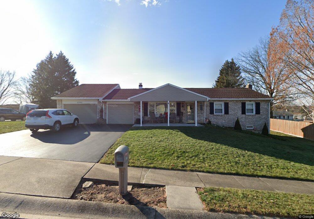
This home is located at 2365 Esbenshade Rd, York, PA 17408 and is currently estimated at $306,611, approximately $183 per square foot. 2365 Esbenshade Rd is a home located in York County with nearby schools including West York Area High School, York Adventist Christian School, and Christian School of York.
Ownership History
Date
Name
Owned For
Owner Type
Purchase Details
Closed on
Jul 12, 2004
Sold by
Smith Gregory C and Estate Of Margaret M Smith
Bought by
Arcuri Frank A and Arcuri Karen L
Current Estimated Value
Home Financials for this Owner
Home Financials are based on the most recent Mortgage that was taken out on this home.
Original Mortgage
$108,800
Interest Rate
6.25%
Mortgage Type
Purchase Money Mortgage
Create a Home Valuation Report for This Property
The Home Valuation Report is an in-depth analysis detailing your home's value as well as a comparison with similar homes in the area
Home Values in the Area
Average Home Value in this Area
Purchase History
| Date | Buyer | Sale Price | Title Company |
|---|---|---|---|
| Arcuri Frank A | $136,000 | Commonwealth Title |
Source: Public Records
Mortgage History
| Date | Status | Borrower | Loan Amount |
|---|---|---|---|
| Closed | Arcuri Frank A | $108,800 |
Source: Public Records
Tax History Compared to Growth
Tax History
| Year | Tax Paid | Tax Assessment Tax Assessment Total Assessment is a certain percentage of the fair market value that is determined by local assessors to be the total taxable value of land and additions on the property. | Land | Improvement |
|---|---|---|---|---|
| 2025 | $4,161 | $123,400 | $34,290 | $89,110 |
| 2024 | $4,057 | $123,400 | $34,290 | $89,110 |
| 2023 | $4,057 | $123,400 | $34,290 | $89,110 |
| 2022 | $4,057 | $123,400 | $34,290 | $89,110 |
| 2021 | $3,933 | $123,400 | $34,290 | $89,110 |
| 2020 | $3,933 | $123,400 | $34,290 | $89,110 |
| 2019 | $3,859 | $123,400 | $34,290 | $89,110 |
| 2018 | $3,828 | $123,400 | $34,290 | $89,110 |
| 2017 | $3,711 | $123,400 | $34,290 | $89,110 |
| 2016 | $0 | $123,400 | $34,290 | $89,110 |
| 2015 | -- | $123,400 | $34,290 | $89,110 |
| 2014 | -- | $123,400 | $34,290 | $89,110 |
Source: Public Records
Map
Nearby Homes
- 2154 Derry Rd
- 2533 Sunset Ln
- 2505 Manor Rd
- 2248 Chestnut Rd
- 2351 Birch Rd
- 2680 Brookmar Dr
- 2700 Thornbridge Rd E
- 2540 Log Cabin Rd
- 2290 School St
- 2451 Log Cabin Rd
- 2762 Sunset Ln
- 0 Log Cabin Rd
- 2381 Sunset Ln
- 2785 Sparrow Dr
- 2050 Sycamore Rd
- 2261 Pine Rd
- 2825 Sparrow Dr
- 1891 Hempfield Dr
- 2755 Anita Dr
- 2450 Walnut Bottom Rd Unit 85
- 0 Manor Rd
- 2355 Esbenshade Rd
- 2179 Derry Rd
- 2560 Manor Rd
- 2360 Esbenshade Rd
- 2183 Derry Rd
- 2557 Esbenshade Rd
- 2173 Derry Rd
- 2350 Esbenshade Rd
- 2345 Esbenshade Rd
- 2553 Manor Rd
- 2187 Derry Rd
- 2556 Manor Rd
- 2168 Croyden Rd
- 2169 Derry Rd
- 2172 Croyden Rd
- 2158 Derry Rd
- 2164 Croyden Rd
- 2549 Manor Rd
- 2335 Esbenshade Rd