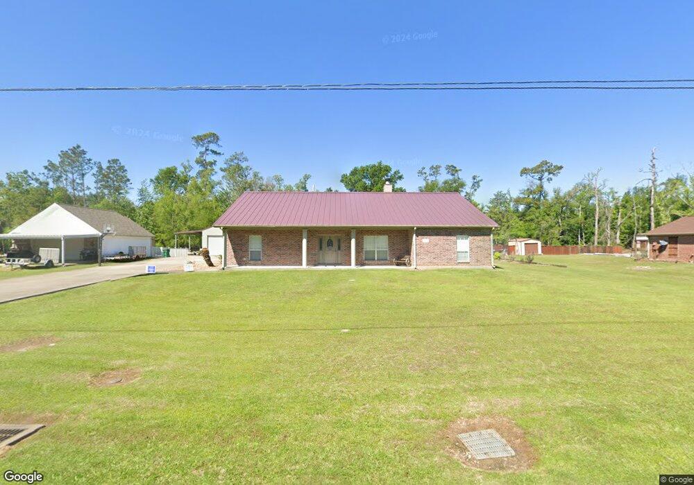
2365 Lyonswood Dr Sulphur, LA 70663
Estimated Value: $278,173 - $323,000
--
Bed
--
Bath
--
Sq Ft
2,657
Sq Ft Lot
About This Home
This home is located at 2365 Lyonswood Dr, Sulphur, LA 70663 and is currently estimated at $295,543. 2365 Lyonswood Dr is a home located in Calcasieu Parish with nearby schools including Fletcher/Maynard Academy, Cypress Cove Elementary School, and Lt. Peter M .Hansen Elementary School.
Ownership History
Date
Name
Owned For
Owner Type
Purchase Details
Closed on
Oct 5, 2010
Sold by
Burleson Russell Wade and Burleson Melanie Fay
Bought by
Crittenden Ellis F and Crittenden Marcie L
Current Estimated Value
Home Financials for this Owner
Home Financials are based on the most recent Mortgage that was taken out on this home.
Original Mortgage
$215,103
Outstanding Balance
$142,090
Interest Rate
4.37%
Mortgage Type
FHA
Estimated Equity
$153,453
Create a Home Valuation Report for This Property
The Home Valuation Report is an in-depth analysis detailing your home's value as well as a comparison with similar homes in the area
Home Values in the Area
Average Home Value in this Area
Purchase History
| Date | Buyer | Sale Price | Title Company |
|---|---|---|---|
| Crittenden Ellis F | $218,000 | Landmark Title Services |
Source: Public Records
Mortgage History
| Date | Status | Borrower | Loan Amount |
|---|---|---|---|
| Open | Crittenden Ellis F | $215,103 |
Source: Public Records
Tax History Compared to Growth
Tax History
| Year | Tax Paid | Tax Assessment Tax Assessment Total Assessment is a certain percentage of the fair market value that is determined by local assessors to be the total taxable value of land and additions on the property. | Land | Improvement |
|---|---|---|---|---|
| 2024 | $1,638 | $22,100 | $2,160 | $19,940 |
| 2023 | $1,665 | $22,100 | $2,160 | $19,940 |
| 2022 | $1,669 | $22,100 | $2,160 | $19,940 |
| 2021 | $1,680 | $22,100 | $2,160 | $19,940 |
| 2020 | $2,287 | $20,020 | $2,070 | $17,950 |
| 2019 | $2,568 | $21,940 | $2,000 | $19,940 |
| 2018 | $1,605 | $21,940 | $2,000 | $19,940 |
| 2017 | $2,515 | $21,940 | $2,000 | $19,940 |
| 2016 | $2,588 | $21,940 | $2,000 | $19,940 |
| 2015 | $2,588 | $21,940 | $2,000 | $19,940 |
Source: Public Records
Map
Nearby Homes
- 0 Tealwood Dr Unit SWL25003561
- 2720 Twin Oaks Dr
- 2720 Twin Oaks Rd
- 1949 Highway 90 W
- 0 Stegal Rd Unit SWL25000774
- 0 Pete Seay Rd Unit 189234
- 0 Pete Seay Rd Unit SWL25102108
- 1919 Dale St
- 916 Tana St
- 842 Kim St
- 0 Kim St
- 3688 E Cabella Dr
- 1940 Currie Dr
- 1668 Marsalise Rd
- 1691 Marsalise Dr
- 0 S Frontage Rd Unit SWL23000364
- 3584 Sierra Cir
- 3053 Highway 90 W
- 1009 Sara St
- 2595 Bayou Cir
- 2377 Lyonswood Dr
- 2343 Lyonswood Dr
- 2386 Lyonswood Dr
- 2770 Twin Oaks Dr
- 2770 Twin Oaks Rd
- 2389 Lyonswood Dr
- 2331 Lyonswood Dr
- 2761 Twin Oaks Dr
- 2771 Sara Jane Dr
- 2760 Twin Oaks Dr
- 2760 Twin Oaks Rd
- 2761 Twin Oaks Rd
- 0 Lyonswood Dr
- 2431 Lyonswood Dr
- 2289 Lyonswood Dr
- 2761 Sara Jane Dr
- 2760 Tealwood Dr
- 2445 W Hwy 90 Hwy
- 2750 Twin Oaks Rd
- 2751 Twin Oaks Rd