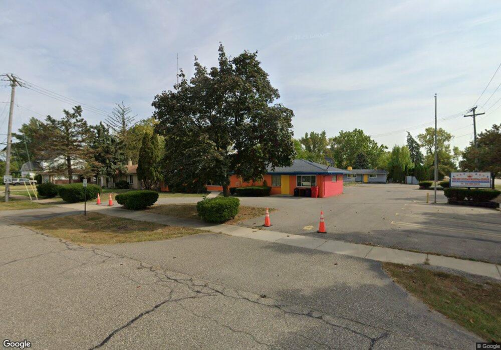
23666 Southfield Rd Unit Bldg-Unit Southfield, MI 48075
--
Bed
--
Bath
3,072
Sq Ft
0.39
Acres
About This Home
This home is located at 23666 Southfield Rd Unit Bldg-Unit, Southfield, MI 48075. 23666 Southfield Rd Unit Bldg-Unit is a home located in Oakland County with nearby schools including Thompson K-8 International Baccalaureate Academy, Oak Park Service Learning Academy, and Oak Park Service Learning Academy Opsla.
Ownership History
Date
Name
Owned For
Owner Type
Purchase Details
Closed on
Oct 1, 2018
Sold by
Bank Chemical
Bought by
Rpu Llc
Purchase Details
Closed on
Dec 12, 2017
Sold by
Eagles Nest Montessori Inc
Bought by
Chemical Bank
Purchase Details
Closed on
Mar 30, 2000
Sold by
Riegner Bryan J
Bought by
Eagles Nest Montessori Inc
Purchase Details
Closed on
Dec 22, 1994
Sold by
Riegner Bernard A
Bought by
Riegner Bryan J and Riegner Nancy
Home Financials for this Owner
Home Financials are based on the most recent Mortgage that was taken out on this home.
Original Mortgage
$250,000
Interest Rate
9.24%
Mortgage Type
Commercial
Create a Home Valuation Report for This Property
The Home Valuation Report is an in-depth analysis detailing your home's value as well as a comparison with similar homes in the area
Home Values in the Area
Average Home Value in this Area
Purchase History
| Date | Buyer | Sale Price | Title Company |
|---|---|---|---|
| Rpu Llc | $248,000 | Ata National Title Group Llc | |
| Chemical Bank | $332,000 | None Available | |
| Eagles Nest Montessori Inc | $270,000 | -- | |
| Riegner Bryan J | $250,000 | -- |
Source: Public Records
Mortgage History
| Date | Status | Borrower | Loan Amount |
|---|---|---|---|
| Previous Owner | Riegner Bryan J | $250,000 |
Source: Public Records
Tax History Compared to Growth
Tax History
| Year | Tax Paid | Tax Assessment Tax Assessment Total Assessment is a certain percentage of the fair market value that is determined by local assessors to be the total taxable value of land and additions on the property. | Land | Improvement |
|---|---|---|---|---|
| 2022 | $8,285 | $145,150 | $24,660 | $120,490 |
| 2021 | $8,984 | $135,460 | $22,430 | $113,030 |
| 2020 | $7,465 | $141,070 | $27,830 | $113,240 |
| 2018 | $10,606 | $129,060 | $51,380 | $77,680 |
| 2015 | -- | $0 | $0 | $0 |
| 2014 | -- | $0 | $0 | $0 |
| 2011 | -- | $128,060 | $0 | $0 |
Source: Public Records
Map
Nearby Homes
- 17863 Bonstelle Ave
- 17573 Mount Vernon St
- 24053 Lathrup Blvd
- 17316 Mount Vernon St
- 17305 Gateway Cir Unit 6
- 17251 Lee St
- 17245 Lee St
- 17400 George Washington Dr
- 18444 Addison Dr
- 0000 W Nine Mile
- 16040 Mount Vernon St
- 25070 Sherwood Cir
- 16245 Roanoke St
- 16275 W 9 Mile Rd
- 16400 N Park Dr Unit 414
- 16400 N Park Dr Unit 1218
- 16400 N Park Dr Unit 810
- 16400 N Park Dr Unit 406
- 15918 Mount Vernon St
- 17581 Roxbury Ave
- 23666 Southfield Rd
- 17915 Louise St
- 17920 Mcclung Ave
- 17885 Louise St
- 23720 Southfield Rd
- 17902 Mcclung Ave
- 00 Mc Clung
- LOT 50 Mc Clung
- 17857 Louise St
- 17880 Louise St
- 23754 Southfield Rd
- 17866 Louise St
- 17945 Mcclung Ave
- 17901 Mcclung Ave
- 17825 Louise St
- 17840 Louise St
- 0 Mc Clung Unit 4913910
- 0 Mc Clung Unit 210055582
- 0 Mc Clung Unit 214060823
- 0 Mc Clung Unit R213059982