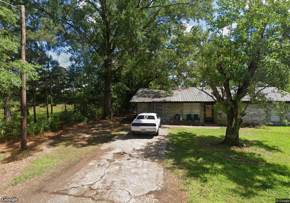
237 Cindy Dr Ashdown, AR 71822
Estimated Value: $112,942 - $177,000
Studio
2
Baths
1,500
Sq Ft
$101/Sq Ft
Est. Value
About This Home
This home is located at 237 Cindy Dr, Ashdown, AR 71822 and is currently estimated at $152,236, approximately $101 per square foot. 237 Cindy Dr is a home located in Little River County with nearby schools including L.F. Henderson Interm. School, Ashdown Elementary School, and Ashdown Junior High School.
Ownership History
Date
Name
Owned For
Owner Type
Purchase Details
Closed on
Sep 26, 2005
Bought by
Raleigh Wanda Sue
Current Estimated Value
Purchase Details
Closed on
Apr 26, 2002
Bought by
First Church Of The Nazarene
Purchase Details
Closed on
Jan 29, 2001
Bought by
Draper Cindy
Purchase Details
Closed on
Nov 30, 1998
Bought by
Ard Michael E and Ard Melissa A
Purchase Details
Closed on
Mar 26, 1998
Bought by
Ard Michael E and Ard Melissa A
Purchase Details
Closed on
Dec 9, 1997
Bought by
Ard Michael E and Ard Melissa A
Purchase Details
Closed on
Dec 15, 1978
Bought by
Mitchell Sarita Faye and Box 754 P O
Purchase Details
Closed on
Jan 1, 1975
Bought by
Mitchell Sarita Faye and Box 754 P O
Create a Home Valuation Report for This Property
The Home Valuation Report is an in-depth analysis detailing your home's value as well as a comparison with similar homes in the area
Home Values in the Area
Average Home Value in this Area
Purchase History
| Date | Buyer | Sale Price | Title Company |
|---|---|---|---|
| Raleigh Wanda Sue | $46,000 | -- | |
| First Church Of The Nazarene | $44,000 | -- | |
| Draper Cindy | $43,000 | -- | |
| Ard Michael E | $42,800 | -- | |
| Ard Michael E | $35,400 | -- | |
| Ard Michael E | $2,800 | -- | |
| Mitchell Sarita Faye | -- | -- | |
| Mitchell Sarita Faye | -- | -- |
Source: Public Records
Tax History
| Year | Tax Paid | Tax Assessment Tax Assessment Total Assessment is a certain percentage of the fair market value that is determined by local assessors to be the total taxable value of land and additions on the property. | Land | Improvement |
|---|---|---|---|---|
| 2025 | $680 | $16,220 | $1,290 | $14,930 |
| 2024 | $680 | $16,220 | $1,290 | $14,930 |
| 2023 | $680 | $16,220 | $1,290 | $14,930 |
| 2022 | $632 | $16,220 | $1,290 | $14,930 |
| 2021 | $574 | $13,710 | $720 | $12,990 |
| 2020 | $574 | $13,710 | $720 | $12,990 |
| 2019 | $574 | $13,710 | $720 | $12,990 |
| 2018 | $574 | $13,710 | $720 | $12,990 |
| 2017 | $573 | $13,710 | $720 | $12,990 |
| 2016 | $521 | $12,440 | $1,040 | $11,400 |
| 2015 | $521 | $12,440 | $1,040 | $11,400 |
| 2014 | $503 | $12,440 | $1,040 | $11,400 |
Source: Public Records
Map
Nearby Homes
Your Personal Tour Guide
Ask me questions while you tour the home.