Estimated payment $747/month
Highlights
- Horse Property
- Mountain View
- Native Plants
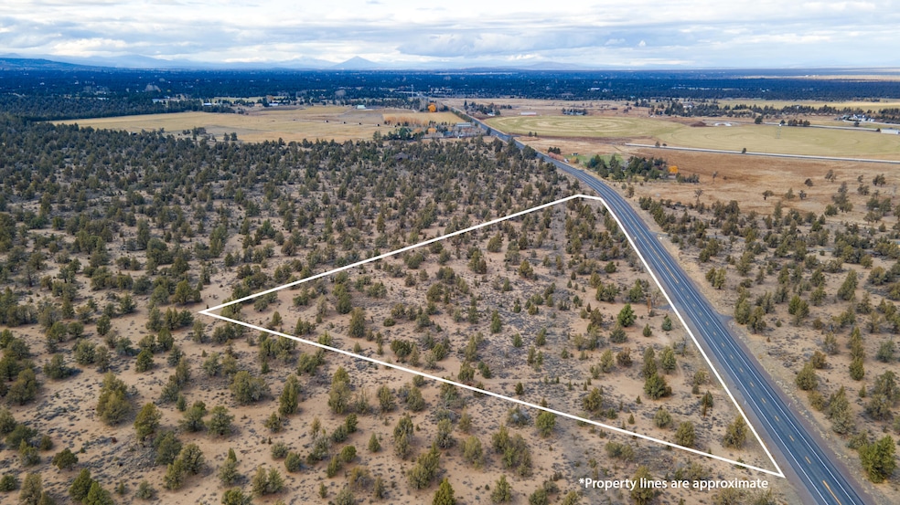
- 11.44 Acre Lot
- No HOA
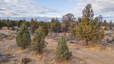
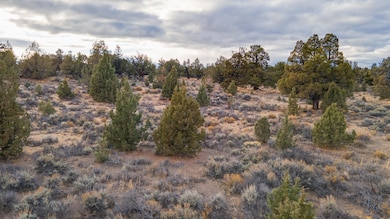
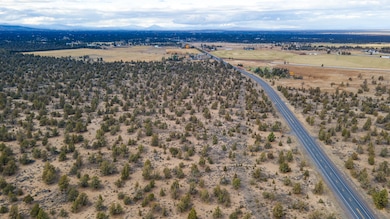
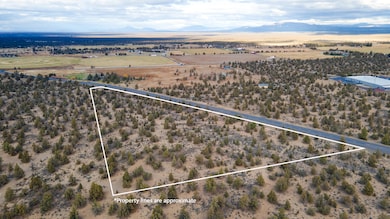
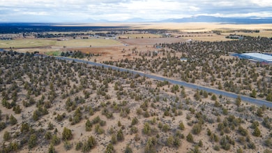
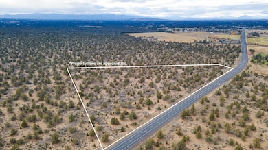
About This Lot
Discover 11.44 pristine acres just 11 miles east of Downtown Bend, offering a true slice of Central Oregon's rugged beauty. This EFU-zoned parcel backs directly to public lands and features mature juniper trees, striking rock outcroppings, and gently rolling natural terrain. With wide-open skies perfect for star gazing and close access to the Millican OHV Trail System and the Oregon Badlands Wilderness Area, this property delivers the peace, privacy, and outdoor lifestyle Central Oregon is known for. A rare opportunity to own acreage so close to Bend—yet surrounded by nature
Property Details
Property Type
- Land
Est. Annual Taxes
- $1,056
Lot Details
- 11.44 Acre Lot
- Native Plants
- Property is zoned EFUAL, EFUAL
Property Views
- Mountain
- Territorial
Schools
- Buckingham Elementary School
- Pilot Butte Middle School
- Mountain View Sr High School
Listing and Financial Details
- Assessor Parcel Number 112505
Community Details
Overview
- No Home Owners Association
Recreation
- Horse Property
Map
Home Values in the Area
Average Home Value in this Area
Tax History
| Year | Tax Paid | Tax Assessment Tax Assessment Total Assessment is a certain percentage of the fair market value that is determined by local assessors to be the total taxable value of land and additions on the property. | Land | Improvement |
|---|---|---|---|---|
| 2025 | $1,056 | $70,530 | $70,530 | -- |
| 2024 | $1,011 | $68,480 | $68,480 | -- |
| 2023 | $951 | $66,490 | $66,490 | $0 |
| 2022 | $877 | $62,680 | $0 | $0 |
| 2021 | $883 | $60,860 | $0 | $0 |
| 2020 | $833 | $60,860 | $0 | $0 |
| 2019 | $810 | $59,090 | $0 | $0 |
| 2018 | $786 | $57,370 | $0 | $0 |
| 2017 | $766 | $55,700 | $0 | $0 |
| 2016 | $727 | $54,080 | $0 | $0 |
| 2015 | $707 | $52,510 | $0 | $0 |
| 2014 | $684 | $50,990 | $0 | $0 |
Property History
| Date | Event | Price | List to Sale | Price per Sq Ft |
|---|---|---|---|---|
| 11/19/2025 11/19/25 | For Sale | $125,000 | -- | -- |
Purchase History
| Date | Type | Sale Price | Title Company |
|---|---|---|---|
| Interfamily Deed Transfer | -- | None Available |
Source: Oregon Datashare
MLS Number: 220212119
APN: 112505
Disclaimer: Certain information contained herein is derived from information provided by parties other than Homes.com. All information provided is deemed reliable, but is not guaranteed to be accurate and should be independently verified.
![]() © 2025 Oregon Datashare (KCAR | MLSCO | SOMLS). All rights reserved. The data relating to real estate for sale on this web site comes in part from the Internet Data Exchange Program of the Oregon Datashare. Real estate listings held by IDX Brokerage firms other than Ten-X are marked with the Internet Data Exchange logo or the Internet Data Exchange thumbnail logo and detailed information about them includes the name of the listing Brokers. Information provided is for consumers' personal, non-commercial use and may not be used for any purpose other than to identify prospective properties the viewer may be interested in purchasing. The consumer will not copy, retransmit nor redistribute any of the content from this website. Information provided is deemed reliable, but not guaranteed.
© 2025 Oregon Datashare (KCAR | MLSCO | SOMLS). All rights reserved. The data relating to real estate for sale on this web site comes in part from the Internet Data Exchange Program of the Oregon Datashare. Real estate listings held by IDX Brokerage firms other than Ten-X are marked with the Internet Data Exchange logo or the Internet Data Exchange thumbnail logo and detailed information about them includes the name of the listing Brokers. Information provided is for consumers' personal, non-commercial use and may not be used for any purpose other than to identify prospective properties the viewer may be interested in purchasing. The consumer will not copy, retransmit nor redistribute any of the content from this website. Information provided is deemed reliable, but not guaranteed.
- 23755 Dodds Rd
- 23669 Dodds Rd
- 61416 Cougar Trail
- 23636 Ten Barr Trail
- 61300 Badlands Ranch Dr
- 24166 Dodds Rd
- 60565 Diamond t Rd
- 24585 Dodds Rd
- 0 Highway 20 Unit 296721434
- 0 Highway 20 Unit 220204469
- 60980 Kramer Ln
- 60995 Ward Rd
- 0 Canyon View Loop Unit Lot 168 220183840
- 3039 NE Brownstone Place
- 0 Tumalo Reservoir Rd Unit 220207981
- 22820 Bear Creek Rd
- 61445 Gosney Rd
- 62118 Cody Jr Rd
- 22540 Rickard Rd
- 61212 Obernolte Rd
- 21244 SE Pelee Dr
- 515 NE Aurora Ave
- 21255 E Highway 20
- 488 NE Bellevue Dr
- 618 NE Bellevue Dr
- 611 NE Bellevue Dr
- 2600 NE Forum Dr
- 2575 NE Mary Rose Place
- 2365 NE Conners Ave
- 1923 NE Derek Dr
- 2020 NE Linnea Dr
- 2001 NE Linnea Dr
- 21302 NE Brooklyn Ct Unit Mountain Room
- 1855 NE Lotus Dr
- 1755 NE Lotus Dr
- 63190 Deschutes Market Rd
- 600 NE 12th St
- 61507 White Tail St
- 525 SE Gleneden Place Unit ID1330994P
- 20513 SE Dorset Place Unit 2
