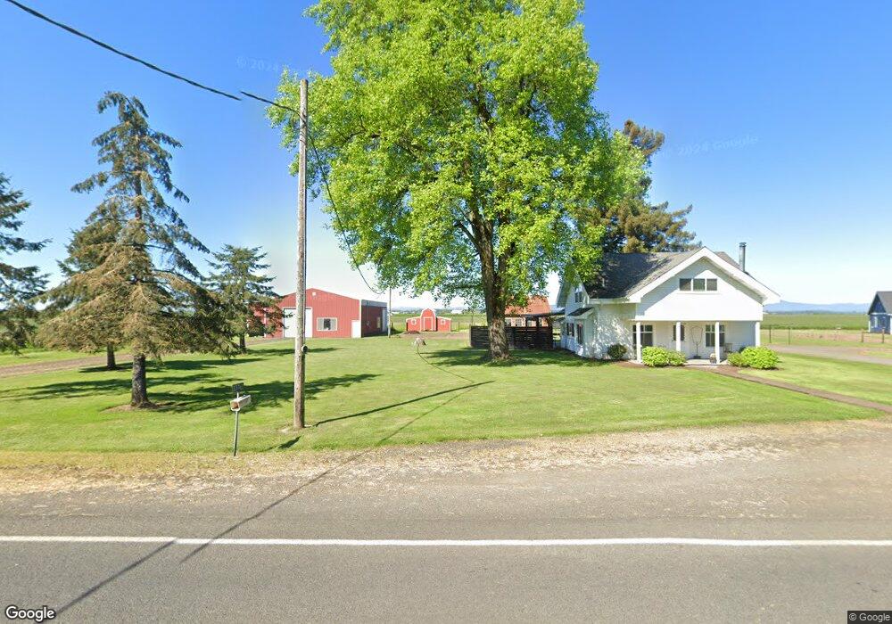
23762 Powerline Rd Harrisburg, OR 97446
Estimated Value: $501,305 - $605,000
3
Beds
2
Baths
1,826
Sq Ft
$303/Sq Ft
Est. Value
About This Home
This home is located at 23762 Powerline Rd, Harrisburg, OR 97446 and is currently estimated at $553,153, approximately $302 per square foot. 23762 Powerline Rd is a home located in Linn County with nearby schools including Harrisburg Elementary School, Harrisburg Middle School, and Harrisburg High School.
Ownership History
Date
Name
Owned For
Owner Type
Purchase Details
Closed on
May 11, 2017
Sold by
Knox Paul V and Knox Judith A
Bought by
Kropf Troy and Kropf Jennifer
Current Estimated Value
Home Financials for this Owner
Home Financials are based on the most recent Mortgage that was taken out on this home.
Original Mortgage
$175,000
Outstanding Balance
$145,346
Interest Rate
4.14%
Mortgage Type
Seller Take Back
Estimated Equity
$407,807
Purchase Details
Closed on
Oct 3, 2013
Sold by
Knox Family Farm Llc
Bought by
Knox Paul and Knox Judith A
Create a Home Valuation Report for This Property
The Home Valuation Report is an in-depth analysis detailing your home's value as well as a comparison with similar homes in the area
Home Values in the Area
Average Home Value in this Area
Purchase History
| Date | Buyer | Sale Price | Title Company |
|---|---|---|---|
| Kropf Troy | $275,000 | Amerititle | |
| Knox Paul | $36,000 | Amerititle |
Source: Public Records
Mortgage History
| Date | Status | Borrower | Loan Amount |
|---|---|---|---|
| Open | Kropf Troy | $175,000 |
Source: Public Records
Tax History Compared to Growth
Tax History
| Year | Tax Paid | Tax Assessment Tax Assessment Total Assessment is a certain percentage of the fair market value that is determined by local assessors to be the total taxable value of land and additions on the property. | Land | Improvement |
|---|---|---|---|---|
| 2025 | $2,607 | $193,310 | -- | -- |
| 2024 | $2,534 | $187,680 | -- | -- |
| 2023 | $2,459 | $182,220 | $0 | $0 |
| 2022 | $2,397 | $176,920 | $0 | $0 |
| 2021 | $2,315 | $171,770 | $0 | $0 |
| 2020 | $2,281 | $166,770 | $0 | $0 |
| 2019 | $2,235 | $161,920 | $0 | $0 |
| 2018 | $2,110 | $157,210 | $0 | $0 |
| 2017 | $2,138 | $152,640 | $0 | $0 |
| 2016 | $1,077 | $86,648 | $0 | $0 |
| 2015 | $1,041 | $84,249 | $0 | $0 |
| 2014 | $1,028 | $81,921 | $0 | $0 |
Source: Public Records
Map
Nearby Homes
- 955 Territorial St
- 881 Arrow Leaf Place
- Lot 9th St
- 735 N Periander
- 741 N Periander
- 729 N Periander
- Lot 7 Territorial St
- 645 Riley Way
- 970 Lasalle St
- 950 Lasalle St
- 1001 Sommerville Loop
- 375 N 6th St
- 888 S 9th St
- 525 S 6th St Unit 4
- 370 S 6th St
- 30540 Priceboro Dr
- 1025 S 6th St
- 1025 S 6th St Unit 83
- 1025 S 6th St Unit 78
- 961 S 9th St
- 23780 Powerline Rd
- 23781 Powerline Rd
- 23815 Powerline Rd
- 23825 Powerline Rd
- 23688 Powerline Rd
- 31118 Diamond Hill Dr
- 31118 Diamond Hill Rd
- 23635 Powerline Rd
- 31277 Diamond Hill Dr
- 31040 Diamond Hill Dr
- 30975 Diamond Hill Dr
- 30978 Diamond Hill Dr
- 24040 Highway 99 E
- 30931 Diamond Hill Dr
- 24023 Powerline Rd
- 24085 Powerline Rd
- 31488 Harris Dr
- 24099 Powerline Rd
- 31545 Harris Dr
- 24180 Powerline Rd