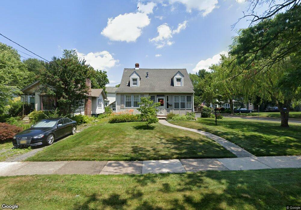
238 Burrwood Ave Haddon Township, NJ 08108
Haddon Township NeighborhoodEstimated Value: $514,236 - $618,000
3
Beds
2
Baths
1,456
Sq Ft
$375/Sq Ft
Est. Value
About This Home
This home is located at 238 Burrwood Ave, Haddon Township, NJ 08108 and is currently estimated at $546,559, approximately $375 per square foot. 238 Burrwood Ave is a home located in Camden County with nearby schools including William G. Rohrer Middle School, Haddon Township High School, and Good Shepherd Regional School.
Ownership History
Date
Name
Owned For
Owner Type
Purchase Details
Closed on
Aug 30, 2023
Sold by
Runge Dale
Bought by
Runge Dale and Runge Maureen Cummings
Current Estimated Value
Purchase Details
Closed on
Apr 3, 2008
Sold by
Clark Paul G and Clark Bridget M
Bought by
Runge Dale
Home Financials for this Owner
Home Financials are based on the most recent Mortgage that was taken out on this home.
Original Mortgage
$170,000
Interest Rate
5.93%
Mortgage Type
New Conventional
Purchase Details
Closed on
Oct 3, 1995
Sold by
Clark William P
Bought by
Clark Paul G and Clark Bridget M
Home Financials for this Owner
Home Financials are based on the most recent Mortgage that was taken out on this home.
Original Mortgage
$101,000
Interest Rate
7.6%
Create a Home Valuation Report for This Property
The Home Valuation Report is an in-depth analysis detailing your home's value as well as a comparison with similar homes in the area
Home Values in the Area
Average Home Value in this Area
Purchase History
| Date | Buyer | Sale Price | Title Company |
|---|---|---|---|
| Runge Dale | -- | None Listed On Document | |
| Runge Dale | $220,000 | -- | |
| Clark Paul G | $16,147 | -- |
Source: Public Records
Mortgage History
| Date | Status | Borrower | Loan Amount |
|---|---|---|---|
| Previous Owner | Runge Dale | $170,000 | |
| Previous Owner | Clark Paul G | $101,000 |
Source: Public Records
Tax History Compared to Growth
Tax History
| Year | Tax Paid | Tax Assessment Tax Assessment Total Assessment is a certain percentage of the fair market value that is determined by local assessors to be the total taxable value of land and additions on the property. | Land | Improvement |
|---|---|---|---|---|
| 2025 | $9,571 | $433,100 | $150,500 | $282,600 |
| 2024 | $9,286 | $229,800 | $81,500 | $148,300 |
| 2023 | $9,286 | $229,800 | $81,500 | $148,300 |
| 2022 | $9,116 | $229,800 | $81,500 | $148,300 |
| 2021 | $9,185 | $229,800 | $81,500 | $148,300 |
| 2020 | $9,082 | $229,800 | $81,500 | $148,300 |
| 2019 | $8,753 | $229,800 | $81,500 | $148,300 |
| 2018 | $8,698 | $229,800 | $81,500 | $148,300 |
| 2017 | $8,549 | $229,800 | $81,500 | $148,300 |
| 2016 | $8,388 | $229,800 | $81,500 | $148,300 |
| 2015 | $8,114 | $229,800 | $81,500 | $148,300 |
| 2014 | $7,974 | $229,800 | $81,500 | $148,300 |
Source: Public Records
Map
Nearby Homes
- 455 Conger Ave
- 223 Guilford Ave
- 421 Lincoln Ave
- 300 Woodlawn Terrace
- 231 Woodlawn Terrace
- 267 Harvard Ave
- 219 Woodlawn Terrace
- 244 E Madison Ave
- 245 E Knight Ave
- 241 E Knight Ave
- 211 Harvard Ave
- 75 E Collings Ave
- 109 Frazer Ave
- 219 E Madison Ave
- 30 Lincoln Ave
- 869 Haddon Ave
- 124 Crestmont Terrace
- 17 Harvard Ave
- 994 Haddon Ave
- 4 W Homestead Ave
- 240 Burrwood Ave
- 601 Shady Ln
- 242 Burrwood Ave
- 236 Burrwood Ave
- 603 Shady Ln
- 600 Shady Ln
- 244 Burrwood Ave
- 234 Burrwood Ave
- 241 Burrwood Ave
- 243 Burrwood Ave
- 602 Shady Ln
- 239 Burrwood Ave
- 245 Burrwood Ave
- 605 Shady Ln
- 246 Burrwood Ave
- 237 Burrwood Ave
- 604 Shady Ln
- 232 Burrwood Ave
- 247 Burrwood Ave
- 235 Burrwood Ave