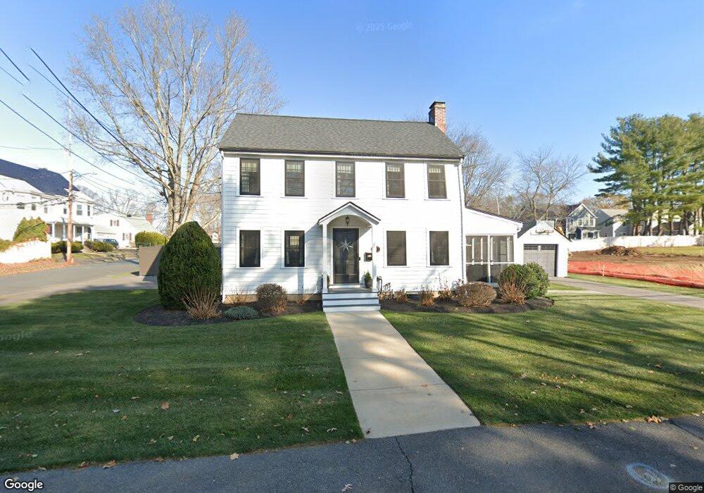
238 Hunnewell St Needham Heights, MA 02494
Estimated Value: $1,316,000 - $1,469,109
4
Beds
3
Baths
1,144
Sq Ft
$1,219/Sq Ft
Est. Value
About This Home
This home is located at 238 Hunnewell St, Needham Heights, MA 02494 and is currently estimated at $1,394,777, approximately $1,219 per square foot. 238 Hunnewell St is a home located in Norfolk County with nearby schools including Eliot Elementary School, High Rock Middle School, and Pollard Middle School.
Ownership History
Date
Name
Owned For
Owner Type
Purchase Details
Closed on
Feb 12, 1993
Sold by
Coletti Carlene T
Bought by
Cook Frederick E and Cook Kerry A
Current Estimated Value
Create a Home Valuation Report for This Property
The Home Valuation Report is an in-depth analysis detailing your home's value as well as a comparison with similar homes in the area
Home Values in the Area
Average Home Value in this Area
Purchase History
| Date | Buyer | Sale Price | Title Company |
|---|---|---|---|
| Cook Frederick E | $173,500 | -- | |
| Cook Frederick E | $173,500 | -- |
Source: Public Records
Mortgage History
| Date | Status | Borrower | Loan Amount |
|---|---|---|---|
| Open | Cook Frederick E | $384,000 | |
| Closed | Cook Frederick E | $45,000 | |
| Closed | Cook Frederick E | $170,000 |
Source: Public Records
Tax History Compared to Growth
Tax History
| Year | Tax Paid | Tax Assessment Tax Assessment Total Assessment is a certain percentage of the fair market value that is determined by local assessors to be the total taxable value of land and additions on the property. | Land | Improvement |
|---|---|---|---|---|
| 2025 | $11,852 | $1,118,100 | $747,100 | $371,000 |
| 2024 | $10,703 | $854,900 | $482,100 | $372,800 |
| 2023 | $10,797 | $828,000 | $482,100 | $345,900 |
| 2022 | $10,215 | $764,000 | $430,600 | $333,400 |
| 2021 | $9,955 | $764,000 | $430,600 | $333,400 |
| 2020 | $9,330 | $747,000 | $430,600 | $316,400 |
| 2019 | $8,469 | $683,500 | $391,600 | $291,900 |
| 2018 | $8,120 | $683,500 | $391,600 | $291,900 |
| 2017 | $7,736 | $650,600 | $391,600 | $259,000 |
| 2016 | $7,508 | $650,600 | $391,600 | $259,000 |
| 2015 | $7,345 | $650,600 | $391,600 | $259,000 |
| 2014 | $6,687 | $574,500 | $326,600 | $247,900 |
Source: Public Records
Map
Nearby Homes
- 263 Hunnewell St
- 70 Booth St
- 35 Andrea Cir
- 443 Central Ave
- 7 Avery St
- 48 Taylor St
- 381 Hunnewell St Unit 381
- 379 Hunnewell St Unit 379
- 132 Hillside Ave
- 400 Hunnewell St Unit 103
- 403 Hunnewell St Unit 403
- 208 Webster St
- 760 Highland Ave Unit 2
- 14 Hunnewell St
- 28 Mercer Rd
- 36 Davenport Rd
- 78 Hunnewell St
- 445 Hillside Ave
- 310 Oakland St
- 609 Hunnewell St
- 246 Hunnewell St
- 246 Hunnewell St Unit 1
- 12 Lester St
- 228 Hunnewell St
- 248 Hunnewell St
- 248 Hunnewell St Unit 248
- 248 Hunnewell St Unit 148
- 13 Lester St Unit 2
- 13 Lester St Unit 1
- 13 Lester St
- 15 Lester St Unit 1
- 15 Lester St Unit 2
- 252 Hunnewell St Unit 1
- 252 Hunnewell St
- 254 Hunnewell St Unit 254
- 254 Hunnewell St
- 252 Hunnewell St
- 254 Hunnewell St
- 254 Hunnewell St Unit 2
- 118 Pine Grove St