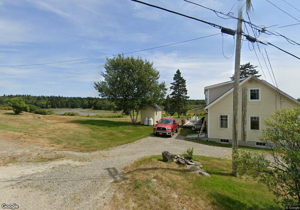
239 Mooseneck Rd Addison, ME 04606
Estimated Value: $168,795 - $274,000
3
Beds
1
Bath
1,008
Sq Ft
$243/Sq Ft
Est. Value
About This Home
This home is located at 239 Mooseneck Rd, Addison, ME 04606 and is currently estimated at $245,199, approximately $243 per square foot. 239 Mooseneck Rd is a home.
Create a Home Valuation Report for This Property
The Home Valuation Report is an in-depth analysis detailing your home's value as well as a comparison with similar homes in the area
Tax History
| Year | Tax Paid | Tax Assessment Tax Assessment Total Assessment is a certain percentage of the fair market value that is determined by local assessors to be the total taxable value of land and additions on the property. | Land | Improvement |
|---|---|---|---|---|
| 2025 | $1,760 | $91,200 | $45,800 | $45,400 |
| 2024 | $1,707 | $91,200 | $45,800 | $45,400 |
| 2023 | $1,570 | $91,200 | $45,800 | $45,400 |
| 2022 | $1,477 | $89,000 | $43,600 | $45,400 |
| 2021 | $1,477 | $89,000 | $43,600 | $45,400 |
| 2020 | $1,502 | $93,900 | $43,600 | $50,300 |
| 2019 | $1,344 | $84,500 | $34,200 | $50,300 |
| 2018 | $1,344 | $84,500 | $34,200 | $50,300 |
| 2017 | $1,344 | $84,500 | $34,200 | $50,300 |
| 2016 | $1,234 | $84,500 | $34,200 | $50,300 |
| 2015 | $1,213 | $84,500 | $34,200 | $50,300 |
| 2014 | $1,132 | $84,500 | $34,200 | $50,300 |
| 2013 | $1,056 | $84,500 | $34,200 | $50,300 |
Source: Public Records
Map
Nearby Homes
- 397 Cape Split Rd
- 00 Eagle Island
- M17L21 Basin Rd
- map 17 Basin Rd Unit lot 24
- 780 E Side Rd
- 0 Pomp Island Unit 1652405
- Lot 13 Reef Point Rd
- Lot 12 Reef Point Rd
- M20L2 E Side Rd
- 29 Reef Point Rd
- 251 Ripley Neck Rd
- Lot 15-5 Fort Williams Rd
- Lot # 15-2 Fort Williams Rd
- Lot B Fort Williams Rd
- 16 & 18 Nelson Way
- Lot #8 Seaberry Landing Rd
- 55 Wilders Way
- 60 W Wind Rd
- Lot #1 Seaberry Landing Rd
- Lot #3 Seaberry Landing Rd
- 243 Mooseneck Rd
- 238 Mooseneck Rd
- 242 Mooseneck Rd
- 218 Mooseneck Rd
- 259 Mooseneck Rd
- 32 Harbor Hills Ln
- 205 Mooseneck Rd
- 210 Mooseneck Rd
- 202 Mooseneck Rd
- 199 Mooseneck Rd
- 274 Mooseneck Rd
- 271 Mooseneck Rd
- 193 Mooseneck Rd
- Lot 1 Pound Rd
- 278 Mooseneck Rd
- Lot 2 Pound Rd
- 1&2 Pound Rd
- 60 Harbor Hills Ln
- 284 Mooseneck Rd
- 287 Mooseneck Rd
Your Personal Tour Guide
Ask me questions while you tour the home.