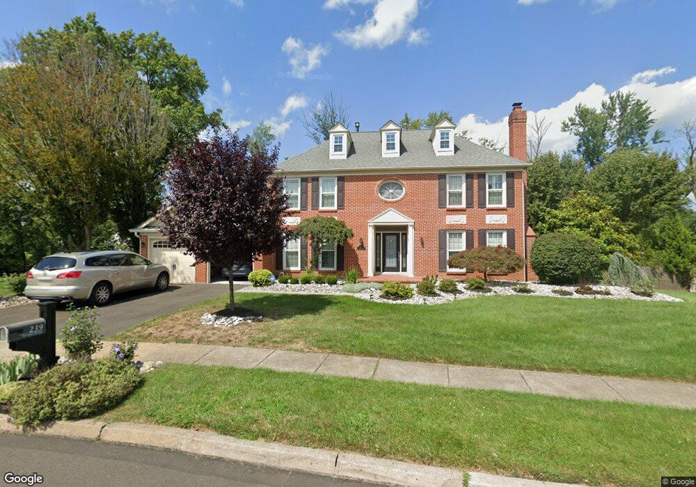
239 Norsam Dr Langhorne, PA 19047
Estimated Value: $911,000 - $950,053
4
Beds
5
Baths
3,342
Sq Ft
$278/Sq Ft
Est. Value
About This Home
This home is located at 239 Norsam Dr, Langhorne, PA 19047 and is currently estimated at $930,263, approximately $278 per square foot. 239 Norsam Dr is a home located in Bucks County with nearby schools including Pearl S. Buck Elementary School, Maple Point Middle School, and Neshaminy High School.
Ownership History
Date
Name
Owned For
Owner Type
Purchase Details
Closed on
Jul 21, 2011
Sold by
Burns Rosanne and Burns Thomas
Bought by
Plappert Mike and Plappert Melissa
Current Estimated Value
Home Financials for this Owner
Home Financials are based on the most recent Mortgage that was taken out on this home.
Original Mortgage
$388,000
Outstanding Balance
$266,932
Interest Rate
4.51%
Mortgage Type
Stand Alone First
Estimated Equity
$663,331
Purchase Details
Closed on
Jun 13, 2003
Sold by
Morley Joel and Morley Marie
Bought by
Burns Thomas and Burns Rosanne
Home Financials for this Owner
Home Financials are based on the most recent Mortgage that was taken out on this home.
Original Mortgage
$384,000
Interest Rate
5.46%
Mortgage Type
Purchase Money Mortgage
Purchase Details
Closed on
Sep 2, 1994
Sold by
Doust David P and Doust Lynette K
Bought by
Jones John R and Jones Karen A
Home Financials for this Owner
Home Financials are based on the most recent Mortgage that was taken out on this home.
Original Mortgage
$230,400
Interest Rate
6.75%
Create a Home Valuation Report for This Property
The Home Valuation Report is an in-depth analysis detailing your home's value as well as a comparison with similar homes in the area
Home Values in the Area
Average Home Value in this Area
Purchase History
| Date | Buyer | Sale Price | Title Company |
|---|---|---|---|
| Plappert Mike | $485,000 | Allied Title Llc | |
| Burns Thomas | $480,000 | -- | |
| Jones John R | $288,000 | -- |
Source: Public Records
Mortgage History
| Date | Status | Borrower | Loan Amount |
|---|---|---|---|
| Open | Plappert Mike | $388,000 | |
| Previous Owner | Burns Thomas | $384,000 | |
| Previous Owner | Jones John R | $230,400 | |
| Closed | Burns Thomas | $48,000 |
Source: Public Records
Tax History Compared to Growth
Tax History
| Year | Tax Paid | Tax Assessment Tax Assessment Total Assessment is a certain percentage of the fair market value that is determined by local assessors to be the total taxable value of land and additions on the property. | Land | Improvement |
|---|---|---|---|---|
| 2025 | $11,586 | $53,220 | $6,920 | $46,300 |
| 2024 | $11,586 | $53,220 | $6,920 | $46,300 |
| 2023 | $11,402 | $53,220 | $6,920 | $46,300 |
| 2022 | $11,103 | $53,220 | $6,920 | $46,300 |
| 2021 | $11,103 | $53,220 | $6,920 | $46,300 |
| 2020 | $10,970 | $53,220 | $6,920 | $46,300 |
| 2019 | $11,777 | $58,440 | $6,920 | $51,520 |
| 2018 | $11,561 | $58,440 | $6,920 | $51,520 |
| 2017 | $11,265 | $58,440 | $6,920 | $51,520 |
| 2016 | $11,265 | $58,440 | $6,920 | $51,520 |
| 2015 | $11,661 | $58,440 | $6,920 | $51,520 |
| 2014 | $11,661 | $58,440 | $6,920 | $51,520 |
Source: Public Records
Map
Nearby Homes
- 257 Norsam Dr
- 462 Scott Ct
- 1102 Waterford Rd Unit 1
- 1988 Knight Cir
- 770 Atkinson Ln
- 2908 Sterling Rd Unit 175
- 2904 Sterling Rd Unit 179
- 120 Shady Brook Dr Unit 89
- 1707 Lynbrooke Dr Unit 120
- 1948 Satter Ct
- 2703 Lynbrooke Dr Unit 81
- 14303 Cornerstone Dr
- 175 Shady Brook Dr Unit 122
- 187 Shady Brook Dr Unit 129
- 8501 Spruce Mill Dr
- 210 Shady Brook Dr
- 354 Shady Brook Dr Unit 180
- 7908 Spruce Mill Dr Unit 656
- 620B Palmer Ln
- 7604 Spruce Mill Dr Unit 661