
Estimated payment $3,520/month
Highlights
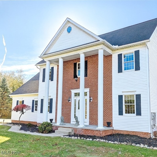
- Colonial Architecture
- Vaulted Ceiling
- Terrace
- Deck
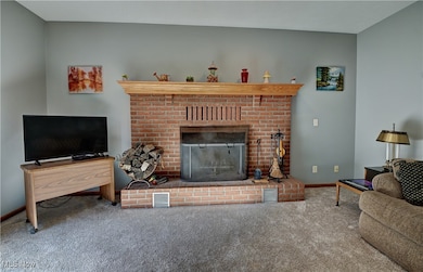
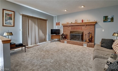
- 2 Fireplaces
- No HOA
About This Home
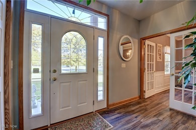
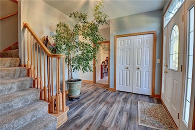
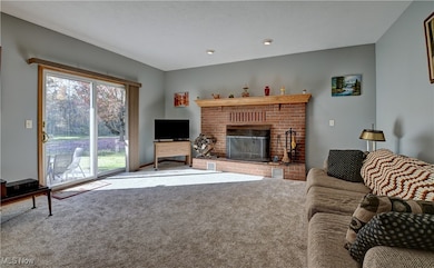
Welcome home to this stunning, custom-built, one-owner beauty in the highly desired Green School District! From the moment you walk in, you’ll feel the difference — 9-foot ceilings, natural light pouring in, and an easy, elegant flow that makes this home feel both luxurious and comfortable. The living room is truly the heart of the home, featuring a cozy wood-burning fireplace and large windows that brighten the entire space. It opens right up to a private patio and partially fenced backyard... perfect for summer BBQs, hosting friends, or sipping your morning coffee in peace. Love to cook or entertain? The kitchen offers tons of counter space and connects effortlessly to the formal dining room, making gatherings a breeze. There’s also a first-floor office and a convenient half bath — ideal for working from home or welcoming guests. Head upstairs to your private retreat: a vaulted-ceiling primary suite with a spa-like bathroom that includes a deep soaking tub, separate shower, and a massive walk-in closet. Step outside onto your private balcony and enjoy views of the quiet, tree-lined backyard. Three more generous-sized bedrooms, a spacious full bath, and a HUGE bonus room (possible 5th bedroom!) with its own balcony round out the second level. And if you’re dreaming of more space — the 9-ft ceiling basement is loaded with potential. It features a gas fireplace, a walk-out to the yard, and plenty of room to finish into whatever you need: rec room, gym, additional living space — you name it. Extras you’ll love: Whole-home generator, Water softener, Dumbwaiter from the 2nd floor to the basement (yes, really!), Large storage shed, Home warranty for peace of mind. Sitting on nearly a full acre of flat, usable land, this home gives you all the space you want while keeping you close to everything Green has to offer.
Listing Agent
Keller Williams Legacy Group Realty Brokerage Email: tmummertz22@gmail.com, 330-704-7198 License #2016005101 Listed on: 10/30/2025

Home Details
Home Type
- Single Family
Est. Annual Taxes
- $5,813
Year Built
- Built in 2000
Lot Details
- 0.91 Acre Lot
- Partially Fenced Property
- Chain Link Fence
Parking
- 3 Car Attached Garage
- Driveway
Home Design
- Colonial Architecture
- Brick Exterior Construction
- Fiberglass Roof
- Asphalt Roof
- Vinyl Siding
Interior Spaces
- 3,062 Sq Ft Home
- 2-Story Property
- Vaulted Ceiling
- 2 Fireplaces
- Wood Burning Fireplace
- Gas Fireplace
- Entrance Foyer
- Basement Fills Entire Space Under The House
Kitchen
- Range
- Microwave
- Dishwasher
Bedrooms and Bathrooms
- 4 Bedrooms
- Walk-In Closet
- 2.5 Bathrooms
- Soaking Tub
Outdoor Features
- Deck
- Patio
- Terrace
- Front Porch
Utilities
- Forced Air Heating and Cooling System
- Heating System Uses Gas
- Septic Tank
Community Details
- No Home Owners Association
- Acadian Heights Allotment Subdivision
Listing and Financial Details
- Home warranty included in the sale of the property
- Assessor Parcel Number 2809920
Map
Home Values in the Area
Average Home Value in this Area
Tax History
| Year | Tax Paid | Tax Assessment Tax Assessment Total Assessment is a certain percentage of the fair market value that is determined by local assessors to be the total taxable value of land and additions on the property. | Land | Improvement |
|---|---|---|---|---|
| 2025 | $8,602 | $118,623 | $19,177 | $99,446 |
| 2024 | $5,553 | $118,623 | $19,177 | $99,446 |
| 2023 | $8,602 | $118,623 | $19,177 | $99,446 |
| 2022 | $4,581 | $87,952 | $14,207 | $73,745 |
| 2021 | $4,293 | $87,952 | $14,207 | $73,745 |
| 2020 | $4,210 | $87,960 | $14,210 | $73,750 |
| 2019 | $3,547 | $69,450 | $9,190 | $60,260 |
| 2018 | $3,627 | $69,450 | $9,190 | $60,260 |
| 2017 | $3,655 | $69,450 | $9,190 | $60,260 |
| 2016 | $3,637 | $65,720 | $9,190 | $56,530 |
| 2015 | $3,655 | $65,720 | $9,190 | $56,530 |
| 2014 | $3,631 | $65,720 | $9,190 | $56,530 |
| 2013 | $3,669 | $66,010 | $9,190 | $56,820 |
Property History
| Date | Event | Price | List to Sale | Price per Sq Ft |
|---|---|---|---|---|
| 11/07/2025 11/07/25 | Price Changed | $575,000 | -4.2% | $188 / Sq Ft |
| 10/30/2025 10/30/25 | For Sale | $600,000 | -- | $196 / Sq Ft |
Purchase History
| Date | Type | Sale Price | Title Company |
|---|---|---|---|
| Interfamily Deed Transfer | -- | -- | |
| Warranty Deed | $15,000 | Endress/Lawyers Title | |
| Warranty Deed | -- | Endress/Lawyers Title |
Source: MLS Now
MLS Number: 5168492
APN: 28-09920
Disclaimer: Certain information contained herein is derived from information provided by parties other than Homes.com. All information provided is deemed reliable, but is not guaranteed to be accurate and should be independently verified.
![]() IDX information is provided exclusively for personal, non-commercial use, and may not be used for any purpose other than to identify prospective properties consumers may be interested in purchasing. Information is deemed reliable but not guaranteed.
IDX information is provided exclusively for personal, non-commercial use, and may not be used for any purpose other than to identify prospective properties consumers may be interested in purchasing. Information is deemed reliable but not guaranteed.
- 2189 E Park Dr
- 3314 Millwood Ln NW
- 2245 Glenross Dr
- 2667 Spade Rd
- 2944 Sunset Dr
- 3541 Elmhurst Cir
- 3609 Glenshire Cir Unit 55B
- 2276 Raber Rd Unit C
- 2913 Warren Dr
- 2771 Superior Dr
- 2664 Pine Lake Trail
- 3212 Deborah Ct
- 2424 Lyndon Dr
- 2500 Marlborough Dr
- 3217 Deborah Ct
- 3634 Kenwood Dr
- 2512 Twin Lakes Dr
- 2511 Royal County Down
- 2754 Irma Dr
- 2575 Myersville Rd
- 13320 Betty Ave NW
- 3811 Glen Eagles Blvd
- 2227 Killian Rd
- 3580 Broad Vista St NW
- 1541 E Turkeyfoot Lake Rd
- 2000 Burgess Dr
- 1000 Springhill Dr
- 3325 Fortuna Dr
- 3049 Chenoweth Rd
- 2979 Chenoweth Rd
- 721-725 Moore Rd
- 3916 Arlington Rd
- 3192 Dotwood St NW
- 1360 Melanie Dr Unit 5
- 888 E Caston Rd
- 9845 Cleveland Ave NW
- 5001 Massillon Rd
- 4250 S Main St
- 4435 Ridgedale Dr Unit 4437
- 720 Shadybrook Dr