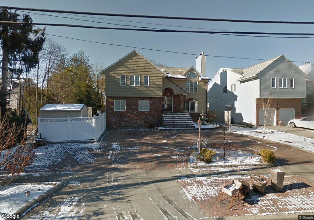
2394 Merrick Ave Merrick, NY 11566
Estimated Value: $806,000 - $1,234,454
6
Beds
5
Baths
3,267
Sq Ft
$312/Sq Ft
Est. Value
About This Home
This home is located at 2394 Merrick Ave, Merrick, NY 11566 and is currently estimated at $1,020,227, approximately $312 per square foot. 2394 Merrick Ave is a home located in Nassau County with nearby schools including Merrick Avenue Middle School, Sanford H Calhoun High School, and Grace Christian Academy.
Ownership History
Date
Name
Owned For
Owner Type
Purchase Details
Closed on
Apr 20, 2023
Sold by
Noto Joseph
Bought by
Stone Spur Llc
Current Estimated Value
Home Financials for this Owner
Home Financials are based on the most recent Mortgage that was taken out on this home.
Original Mortgage
$550,000
Interest Rate
6.73%
Mortgage Type
Stand Alone First
Create a Home Valuation Report for This Property
The Home Valuation Report is an in-depth analysis detailing your home's value as well as a comparison with similar homes in the area
Home Values in the Area
Average Home Value in this Area
Purchase History
| Date | Buyer | Sale Price | Title Company |
|---|---|---|---|
| Stone Spur Llc | $369,750 | Your Title Experts |
Source: Public Records
Mortgage History
| Date | Status | Borrower | Loan Amount |
|---|---|---|---|
| Closed | Stone Spur Llc | $550,000 |
Source: Public Records
Tax History
| Year | Tax Paid | Tax Assessment Tax Assessment Total Assessment is a certain percentage of the fair market value that is determined by local assessors to be the total taxable value of land and additions on the property. | Land | Improvement |
|---|---|---|---|---|
| 2025 | $30,406 | $820 | $211 | $609 |
| 2024 | $6,014 | $820 | $211 | $609 |
| 2023 | $25,416 | $820 | $211 | $609 |
| 2022 | $25,416 | $820 | $211 | $609 |
| 2021 | $36,988 | $788 | $203 | $585 |
| 2020 | $28,237 | $1,522 | $597 | $925 |
| 2019 | $28,952 | $1,522 | $597 | $925 |
| 2018 | $27,191 | $1,522 | $0 | $0 |
| 2017 | $17,513 | $1,522 | $597 | $925 |
| 2016 | $24,026 | $1,522 | $597 | $925 |
| 2015 | $6,040 | $1,522 | $597 | $925 |
| 2014 | $6,040 | $1,522 | $597 | $925 |
| 2013 | $5,715 | $1,522 | $597 | $925 |
Source: Public Records
Map
Nearby Homes
- 2043 Ripley Ln
- 2538 Bradley Ct
- 45 Gregory Ave
- 217 Bayview Ave
- 163 Wynsum Ave
- 43 Wynsum Ave
- 2077 Byron Rd
- 174 Babylon Turnpike
- 212 Babylon Turnpike
- 131 Gregory Ave
- 2203 Washington St
- 109 Elliot St
- 1811 Bedford Ave
- 2729 Shore Dr
- 110 Hampton Way
- 2341 Dobson Ave
- 1763 E Berkshire Rd
- 48 Rosebud Ave
- 2688 Rosebud Ave
- 80 Dobson Ave
- 2394 Merrick Ave
- 2388 Merrick Ave
- 2004 Kirkwood Ave
- 2018 Kirkwood Ave
- 120 Merrick Ave
- 15 Kirkwood Ave
- 2044 Kirkwood Ave
- 2037 Cornell Place
- 20 Kirkwood Ave
- 20 Kirkwood Ave
- 2030 Cornell Place
- 1 Arbor Ln
- 2389 Kowal Ct
- 3 Arbor Ln
- 2395 Kowal Ct
- 2036 Cornell Place
- 1980 Kirkwood Ave
- 5 Arbor Ln
- 2043 Cornell Place
- 1999 Kirkwood Ave
Your Personal Tour Guide
Ask me questions while you tour the home.